Here’s a detail from the 1795 “Plan of the Situation of the University” map:
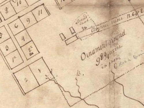
The legend of the map says:
“A. the old chapel spring
B. & C. springs which ye Commissioners
intend to improve for ye University
Lot 2= contains ye President’s house
The Avenue is to pass over Point Prospect.”
Okay, so let’s do a little interpreting of this map. It shows Columbia Street, coming south to Cameron Ave, but it does not show Columbia continuing past Cameron. Instead lots 1 and 2 meet with no road between them. Cameron is only about two blocks long and a proposed extension is shown which is akin to what is now Cameron Avenue/Country Club Road/Gimghoul Lane, as it was to pass over “Point Prospect,” which I believe is the name of the Rock outcropping just east of Gimghoul Castle, (incidentally that spot gives an excellent view of Durham’s Triassic Basin to the east - hence the name Point Prospect). The three buildings in the center of campus are, of course, South Building and Old East and Old West.
Chapel Spring Branch
So this clarifies the origin of “Chapel Spring Branch.” It was, of course, called that after the spring that served the Chapel. That would be New Hope Chapel, which gave its name to Chapel Hill. It is interesting that the map refers to the spring as “the old chapel spring.” I wonder if the mapmaker was implying that either the spring or the chapel had already been abandoned by 1795?
The New Hope Chapel
I have often heard it said that the New Hope Chapel for which Chapel Hill was named was located about where the Carolina Inn is today, and now I see what the evidence for that is. The “old chapel spring” is clearly shown arising on Lot 1 on this map. Naturally the New Hope Chapel would have been somewhere nearby. I can therefore see why the assumption would arise that the Chapel was on the adjacent Lot 2 (which is where the Carolina Inn is.)
But, looking at the map, I think it is also possible that the New Hope Chapel may have been on Lot 1, which would put it about where Peabody Hall is today, rather than the Carolina Inn.
Lot 2= is about where the Scuttlebutt used to be, at the northeast corner of Columbia Street and Cameron Avenue. The map seems to show a building there already in 1795 and the maps states that Lot 2= “conatins” the president’s house, presumably implying that the president’s house was already built at that time, rather than merely being proposed for that site. So figure that the president’s house was not built on the same lot with the New Hope Chapel.
I wonder if any of the histories of UNC address the location of the New Hope Chapel based on some other evidence?


No comments:
Post a Comment