The well established Native American path across the southeast Piedmont was commonly called the Indian Trading Path, the Catawba Path, the Old Trading Path, or the Western Trading Road. In its full extent, the Trading Path ran from the vicinity of Petersburg, VA to Mobile, AL. More locally, the Trading Path had a well defined route from the Eno River to the Haw River. From the Eno it more or less followed the current path of Old NC 10, Bowden Road, and Old Hillsborough Road to the present site of the Hawfields Presbyterian Church on NC Hwy 119.
From there, the Trading Path divided briefly. One route following Hwy 119 south into what is now Swepsonville and fording the Haw River just below the present day ruins of the mill dam. The other route followed an alignment formed by Kimrey Road, North Jim Minor Road, and the private driveway now named Old Reatkin Lane, crossing the Haw at the place known as Galbreath Ford/Ferry/Bridge about ½ mile below NC Hwy 54.
Some have said that there was not one Trading Path, but that there were many Trading Paths, being a series of braided footpaths that led between and among several different fording sites on each major river that the Trading Path crossed. The Many-Trading-Paths theory is propounded in opposition to the view that there was only one true Old Trading Path. It appears that there is truth in both points of view. In the 18th century, there was really just one route that was widely known as the Old Trading Path between the Eno and Haw Rivers, except for the final leg where the path divided on its way to two (or perhaps three) different fords. When old land and court records of Orange County refer to the Trading Path or Trading Road, they mean this particular route.
From the Eno River
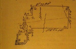
From the west bank of the Eno River, the Trading Path crossed the Granville land grant to Henry Lemmon (Gv 25) though neither the text of the grant nor the accompanying survey shows the Trading Path. Next the route crossed the land grant to James Rayley (Gv 142), the survey showing the route as an un-named dotted line:
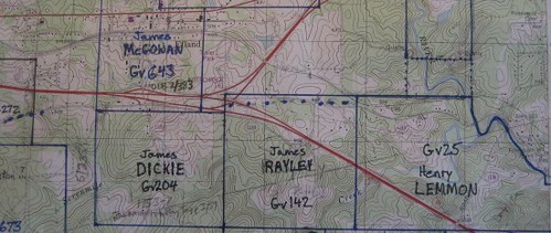
Then the Trading Path crossed right between the Granville grants to James Dickie (Gv204) and James McGowan (Gv 643) probably forming the border between them, though neither the grants nor surveys mention it. The Court of Pleas and Quarter Sessions minutes for June 1755 note: "James Dickey and Robert Witty from hence forward, do work on the Trading path Road, & under the Inspection of Major Mebane."
Next the path crossed German Baxter’s state land grant (NC 272), where it is depicted in detail without being named:
Part of Baxter’s land was conveyed to Mehitabel Coit in 1789 (ODB4, pg 201) “on the side of the Great Road formerly called the Old Trading Path.”
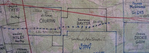
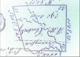
From there, the Trading Path entered land granted by Granville to William Churton (in Misc Gv Papers; Survey 15 Aug 1760). The Trading Path is shown plainly and labeled “Trading Path” on the survey:
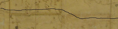
Next the Trading Path entered a 5,000 acre tract which had been granted to George Pollock in 1728. William Churton’s 1754 plat of the Pollock Tract distinctly shows a road crossing the southern end of the tract following almost precisely the present alignment of Old NC 10 and Bowden Road. The Trading Path is so faint on the Pollock Plat, that I added a black line that runs parallel to the route just north of it:
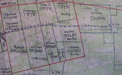
Descendants of George Pollock granted several parcels near or on the Trading Path in the 1840’s: To Wesley Miles along “the Old Great Road,” to Charles C. Smith “on the north side of the Old great Road,” and to Wilson Brown on “the Old Great Road” (ODB 29, pg 447). Although none of those deeds happen to refer to it as the Trading Path, other land records of that location do. During the Revolution, as Hawfields settlers filed State land entries left and right, local surveyor James Smith obtained state land grants for two parcels that were within the Pollock Tract. His state grant NC 30 amounts to the west half of Pollock’s lot #2. And NC 179 is part of Pollock’s lots #1 and #2 – both immediately along the current route of Old NC Hwy 10 and Bowden Road. These grants to James Smith were no doubt invalidated, but notably both of these grants refer to being “on the old Trading Road.”
Crossing Moseley Tract 1
Leaving the Pollock Tract, the Trading Path entered a 10,000 acre tract which had been granted to William Moseley in 1728. Moseley’s grant explicitly mentions “where the Indian Trading Path crosses” Haw Creek (PB 2, pg 222). This land later passed into the hands of Samuel Strudwick. Strudwick parted out Moseley’s tracts, selling to various settlers who had occupied this area starting in the latter 1740’s. Along the Trading Path, Strudwick sold 718 acres to Alexander Mebane in 1769 (ODB 2/550) – land that Mebane had occupied 20+ years. While the deed to Mebane makes no mention of the Trading Path, the minutes of the Orange County Court of Pleas and Quarter Sessions for December 1752 authorized Mebane to build a grist mill “near the trading path.” That mill was more recently known as Gill’s Mill on Haw Creek, just below Bowden/Hillsborough Road. Court of Pleas Minutes for June 1759 mention that Alexander Mebane's house is on the "trading path road." Minutes for September 1759 refer to "the Western Path where Alex Mebane Esq lives." Thus showing that the Western Path and the Trading Path were interchangeable terms for the same road.
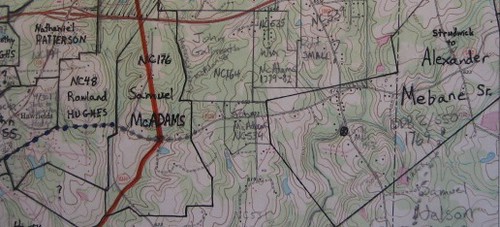
Other parts of Moseley Tract 1 were claimed by John McAdams (NC 534) and Samuel McAdams (NC 196) under state land grants (in direct conflict with Strudwick’s ownership). Neither of the McAdams grants mentions or shows the Trading Path.
Crossing the Lovick Tract
The Trading Path then crossed into the 1728 land grant of John Lovick. The original grant to Lovick also twice explicitly mentions “where the Indian Trading Path” crosses various creeks (NC Patent Book 2, pg 223). The Lovick Tract was more or less forfeited during the Revolution because of the owner’s British allegiances, but various state land grant claims across the Lovick Tract show a series of properties with the Trading Path crossing them:
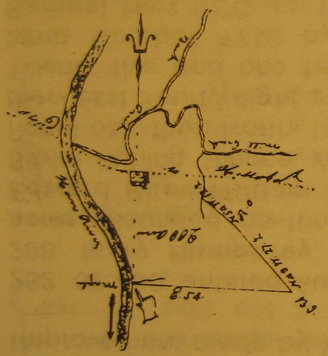
Rowland Hughes’s land grant survey (NC 48) definitely shows the Trading Path, although it is unnamed. John Sloss’s land grant (NC 40) had roads on two sides, one the “old Trading Road” and the other “the Great Road.”
Interestingly, the legal description calls the more northerly of the two road alignments “the old Trading Road” referring to essentially modern Kimrey Road, leading to the Galbreath Ford site about ½ mile downstream of the modern NC Hwy 54 bridge. See The Galbreath Ford below.
The adjacent land grant north of John Sloss’s was William Rainey’s (NC 182), which also refers to this road as “the old Trading Road.”
On the strength of this alone, the evidence would seem to indicate that the Galbreath Ford was the sole route of the Trading Path, but as we will see, the Granville Grant to Campbell and the 1728 grant to Lovick show that the Trading Path ford was also at Swepsonville.

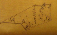
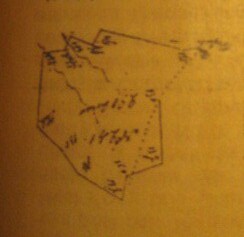
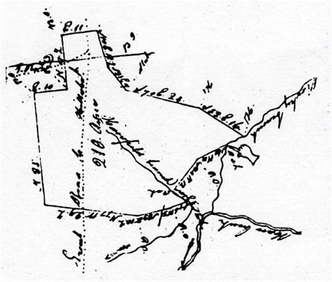
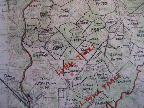
Thomas Lockart’s land grant (NC 67) does not show or mention the Trading Path, but the next survey to the southwest, George Allen’s (NC 162) clearly shows an unnamed road. Likewise James Fruit’s land grant (NC 220) shows the Trading Path crossing the south end of his grant, as well as part of the road to Galbreath Ford which crossed his grant further north; neither road is mentioned by name:
[George Allen Pic]
Following Hwy 119, the Trading Path formed the boundary between James Kennedy (NC 417) and Joseph Sloss (NC 62), both surveys plainly showing “the Great Road.” Next the Trading Path crossed the land grant of Moses Crawford (NC 91) but it was neither shown nor mentioned.
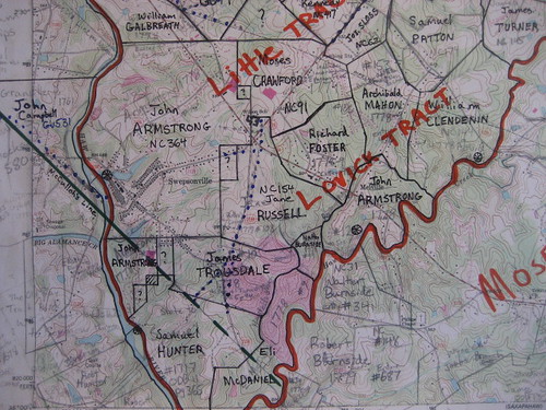
Jane Russell’s survey (NC 154) clearly shows the road forking (both forks called “the Great Road”):
The western fork led to the ford in Swepsonville. The southerly fork led across James Trousdale's land grant (NC 1, showing the road) to the third in the trilogy of fords in the Swepsonville area, the Island Ford. See The Island Ford below. Leaving Jane Russell’s along the western fork, the Trading Path entered the land grant of John Armstrong (NC 364). Though not shown on Armstrong’s plat, the Trading Path crossed through the middle of Armstrong’s land reaching the banks of the Haw River in what is now Swepsonville.
Butler’s Ford
The Trading Path proper crossed the Haw River just below the Swepsonville mill site. This ford is shown on Granville’s 1761 land grant to John Campbell (Gv 531) on the west side of the Haw. This land had originally been surveyed for Adam Davies and the Davies survey explicitly shows the “Western Trading Path.” The legal description refers to Campbell’s grant as being “on the Trading Path.” Here’s that survey:
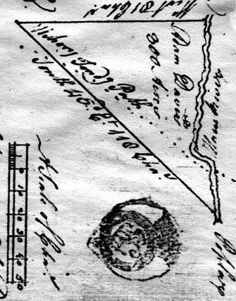
John Campbell applied to the Orange County Court of Pleas and Quarter Sessions for permission to build a mill on the Haw River in Aug 1761, but was denied. Just two years after denying Campbell’s mill petition, the Orange Court of Pleas in 1763 granted Henry Eustace McCulloh permission to condemn property opposite Campbell’s grant, on the east bank of the Haw “above the Trading Path” to build the first mill at Swepsonville. There is no surviving record of a transfer from Campbell to McCulloh, but Campbell was a wealthy businessman of Bertie County and an in-law of McCulloh’s. Campbell was among those who were appointed by Power of Attorney to represent Henry McCulloh regarding the sales of land in North Carolina (5 CSR 779). Campbell was apparently acting as a proxy, who obtained the 1761 land grant in trust for the McCulloh’s, which was a common practice of theirs.
The mill site at Swepsonville changed hands many times, but the adjacent farm was variously owned by John Armstrong, Gen. William Butler and Richard Christmas. During the Revolutionary War, the site was commonly called Butler’s Ford, although it was no doubt known by other names as well.
The Galbreath Ford
William Galbreath’s land grant at the confluence of Back Creek and the Haw River included a ford (no doubt ancient) that came to be called Galbreath Ford. Galbreath operated a ferry there for a time and eventually a bridge was built there, known as Galbreath Bridge into the 20th century.
The Galbreath Ford and the Butler Ford both led to the north side of Big Alamance Creek. From there, the route of the Trading Path swung north and uphill, crossing Little Alamance and Gun Creeks higher up where they are shallower, then swinging south and crossing Big Alamance Creek near what is now the Village of Alamance. From there, the Trading Path was virtually identical to NC Hwy 62, cutting diagonally across Henry McCulloh’s Great Tract #11, as shown on Matthew Rowan’s 1745 survey:
Notice that Rowan shows the ford distinctly north of mouth of Big Alamance Creek.
Approaching from the east, the Galbreath Ford route of the Trading Path passed through the land grants of James Murdaugh (NC 78, not shown or mentioned), James Fruit (NC 220, shown but not named), Samuel Patton (NC 175, not shown or mentioned), Richard Gott (NC 502, shown but not named) and William Galbreath (NC 248, shown as "Road to Hillsborough").
The Island Ford
Just after NC Hwy 119 crosses NC Hwy 54, the road into Swepsonville forks. The left fork is now Alfred Road and that was the road to the Island Ford. The Island Ford was located just south of the islands at the Puryear Mill; Tom Burke Lane is a remnant of the road leading down to the river. It would be interesting to get the landowners' permission and check out the route of that road in more detail.
Unlike the Galbreath and Butler Fords, the Island Ford crossed the Haw south of the mouth of Big Alamance Creek, obviating the problem of fording Big Alamance – no doubt one of the reasons why this ford was developed. The Island Ford was apparently established by the time Collett made his 1770 map of North Carolina, as two fords are clearly shown near Armstrong’s Mill, one of them south of the mouth of Big Alamance Creek:

Collett seems to be the only source that associates the "Western or Trading Path" - as Collett calls it - with the Island Ford and the route on the south side of Big Alamance Creek. Henry Mouzon's 1775 map shows the same thing, but Mouzon drew very heavily from Collett's map.
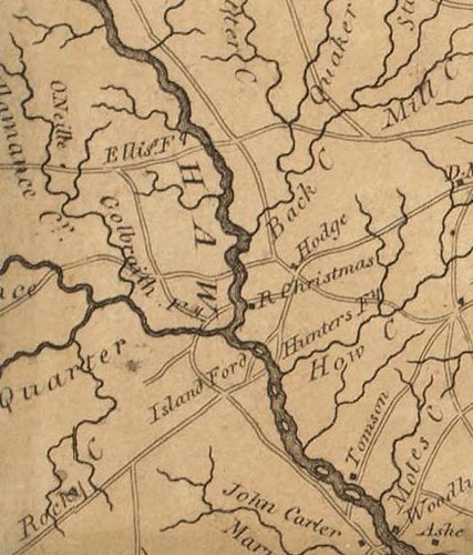
Still further to the south, just above the mouth of Haw Creek, the Hunter family set up a ferry in the early 19th century or perhaps late 18th. The Island Ford and Hunter’s Ferry are both shown distinctly on the 1808 Price-Strother map of North Carolina. The site of Swepsonville is labeled R. Christmas:
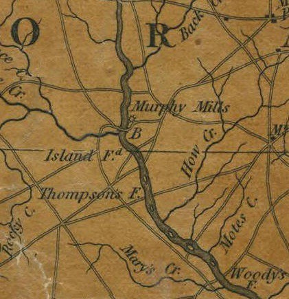
The 1833 McRae-Brazier Map of North Carolina shows the same crossings (though Hunter’s Ferry is unlabeled) as well as still another crossing, Thomspon’s Ferry a little further downstream. The site of Swepsonville is labeled Murphy Mills on this map:
The Old Trading Path
Old court and land records in Orange County mention the Old Trading Path or Old Trading Road many times. Looking through all of the 18th century court and land records that still exist for Orange County (including the Granville Grants, the State Land Grants, the minutes of the Court of Pleas and Quarter Sessions, the minutes of Hillsborough Superior Court and the entirety of Orange County Deed Books 1 through 16), it appears that all references to “the old Trading Path,” “old Trading Road,” “Trading Road” or “Trading Path” refer to the route I have described above (i.e. a mostly unitary route from Hillsborough to Hawfields and a dual route from Hawfields to the Haw River).
The various roads leading to Woody’s Ferry, Hunter’s Ferry, the Saxapahaw Ford, the Island Ford, and Trollinger’s Ford were all parts of major routes from Hillsborough to Salisbury at various times. Probably all of these crossings were known to the Native Americans from much earlier times, but no old Orange County records ever refer to any of these crossings or the roads that led to them as being the Trading Path (though Collett shows the Western or Trading Path as crossing at the Island Ford). And the very oldest land records for the area that is now Orange County – the 1728 Proprietary land grants to John Lovick and William Moseley – all agree that the Old Trading Path followed NC Hwy 119 crossing the Haw at what is now Swepsonville. Some records show that the Galbreath Ford was the Trading Path as well. Probably both fords, which are near each other, were used, one being better than the other depending on the water level.


Mark,
ReplyDeleteMcCulloch's surveyors showed the TP crossing the Haw in the vicinity of Cedar Cliffs, well downstream from Great Alamance. This sort of expands your crossing hypotheses. Add to that the quite careful work of Carole Troxler that located at least one TP crossing at Piney Ford/the Town of Haw River and you have a corridor of roads employing a number of crossings suitable for use under various weather and transport conditions.
This comment has been removed by the author.
ReplyDeleteAddendum to the above: the McCulloch surveys, made circa 1733-36, may have reflected the packhorse crossing though I believe that by that time wagons were operating in the area. Alternatively, the month of survey may have influenced their choice of crossings. There is some evidence indicating that John Lawson also crossed the Haw at Cedar Cliffs.
ReplyDeleteLawson wrote: "At last, determining to rest on the other side of a Hill, which we saw before us; when we were on the Top thereof, there appear'd to us such another delicious, rapid Stream, as that of Sapona, having large Stones, about the bigness of an ordinary House, lying up and down the River . . . the famous Hau-River, by some called Reatkin."
ReplyDeleteI think Lawson was most likely crossed the Haw at Swepsonville. Next time you drive from Hawfields to Swepsonville, look down NC 119 and you will see a hill on the west side of the river directly opposite the path of NC 119 - just the sort of spot from which one might look out and see the Haw and its rapids - and also directly on the Trading Path.
I have heard it suggested that perhaps Lawson paused on top of Bass Mountain or one of the Cane Creek Mountains and that the ford he saw was at Cedar Cliffs, but notice that Lawson does not say he stopped on a mountain, merely a hill. And in any case, why would their route have gone over the top of a mountain (even if a modest 'mountain' of the Alamance variety)? No standard route passed that way and neither did Lawson.
I don't really know how this blog thing works so I apologize for doing it incorrectly...I am very keen on these land grants you have taken an incredible amount of time to catalog and wonder if you could shed some light on James Forrester Sr.s will of 1755 where he wills his land and plantation to his children William, James, Benjamin, Thomas and his son-in law John Manning land on the Eno River (both the North and South side) somewhere in an area he names as "bounded by the High Hill brench(sic)" If any of these names mean anything please let me know.
ReplyDelete...just thinking out loud...could this have been the Haw Hill branch that James Forrester Sr. was referring to? Second question... I came across a deed transfer from the McIlwains to James Forrester about 1753. I'll have to look that up..but I recognized a similar name in the blog somewhere.
ReplyDelete