Pretty much this entire blogpost is extracted from John Scott Davenport's excellent article Early Settlers in the North Carolina Piedmont on Land Sold by Henry McCulloh within Granville's District, 1749-1763 (NCGenSoc Journal, #4, 1978). I also cross-referenced against William D. Bennett's transcripts of Orange Deed Books 1-5. He's transcripted several more deed books, but I haven't made it through them all.
According to Davenport: In 1737 Henry McCulloh through proxies obtained from the King an order to grant 1.2 Million acres of land in the North Carolina Piedmont. However, the deed for this 1.2 Million acres was not issued until 1745. These tracts were 12 squares of 100,000 acres each and subdivided into smaller tracts so as to pass on proportionate shares to smaller investors in McCulloh's scheme.
Defining the Granville District
The timing of this is important, for the King had granted a deed in fee simple absolute to Earl Granville in 1744 for a 60 mile wide swath of North Carolina, from the Virginia line southward to Ocracoke Inlet. This line, the Granville Line was run from Ocracoke Inlet westward in 1743 by a delegation appointed by Granville and Gov. Gabriel Johnston. The surveyors of the Granville Line stopped at the confluence of the Haw and Deep Rivers in what is now Chatham County, but the line was extended further westward in 1746 and still further west in 1753. Thus, McCulloh's deed was issued in 1745 after Granville's 1744 deed, but before Granville's line had been extended west of Mermaid Point.
McCulloh Tracts in Conflict with Granville
This presented a big problem because McCulloh's Great Tracts 8, 9, 10, 11 & 12 were partly or wholly within the Granville District. Because McCulloh's tracts were all established before 1746 when the Granville Line was extended, and because the order from George II came earlier even than Granville's deed, McCulloh felt that his title was superior to Granville's regarding the Great Tracts that were north of the Granville Line (see McCulloh memos in The Colonial Records of North Carolina). McCulloh and Granville went through considerable wrangling and they did not reach an agreement until 1755.
Granville McCulloh Agreement 1
Under that agreement McCulloh was to register all sales in Granville's land office and the purchasers were to pay their quit rents (taxes) to Granville. In 1760 George III was crowned and he elevated Granville to President of the Privy Council, making him extremely powerful on both sides of the Atlantic.
Granville McCulloh Agreement 2
At the end of 1761, McCulloh and Granville reached a new agreement under which McCulloh would have two years to sell his lands within the Granville District and then thereafter he would deed the remainder to Granville in fee simple. It was at this time that Henry Eustace McCulloh and other agents for Henry McCulloh began furiously selling off land. However Davenport says sales were low owing to Native American conflicts in western North Carolina. Those problems did not affect Great Tracts 11 & 12 as much, because these two were more eastern.
Location of McCulloh's Great Tract 11
Tract 11 was a square rotated 45 degrees forming a diamond. It was 12.5 miles on a side, stretching from the old Rowan/Orange County line on the western tip to Swepsonville on the eastern end. Thus Tract 11 included big parts of what are now Alamance and Guilford Counties as well as small parts of Chatham and perhaps Randolph Counties. Tract 12 was in what are now Durham and Granville Counties and we shall discuss that tract another time (also a 12.5x12.5 mile square, but rotate 35 degrees instead of 45).
The Death of Granville
Under the terms of the 1761 agreement, McCulloh was to have to the sooner of the end of 1763 or until Granville's death to sell lands that conflicted with the Granville District. Granville died in January of 1763, cutting McCulloh's time by almost 50%. Davenport points out that there were numerous deeds after Granville's death but supposes that these deeds were purusant to contracts made before Granville's death. I cannot help but wonder whether the contracts were merely back-dated.
H. E. McCulloh's Deed of Surrender to the Granville Estate
When Henry E. McCulloh surrendered to Granville's estate the unsold lands in McCulloh's Great Tract #11, he listed out all of the parties to whom his father Henry McCulloh had sold land in Tract 11. Davenport lists all of these as an interesting record of who all the purchasers in Tract 11 were:
1. George Clapp, 320 acres, 20 sep, 1757
2. David Low, 350 acres, 8 Mar, 1758
3. Peter Helton, 320 acres, 11 Mar, 1758
4. Frederick Brown, 233 acres, 11 Mar, 1758
5. William Piggott, 297 acres, 11 Mar, 1758; ODB3/95 part to John Wheeler; PatentBk19/449.
6. Joseph Boggs, 546 acres, 11 Mar, 1758
7. Charles Davis, 187 acres, 2 Aug, 1758; see ODB2/562 to Jeremiah Piggot; on Cain Ck.
8. Joseph Buckingham, 171 acres, 7 Aug, 1758
9. Benjamin Piggott, 160 acres, 7 Aug, 1758
10. James Woods, 200 acres, 8 Aug, 1758
11. John McGee, 305 acres, 8 Aug, 1758
12. Thomas Low, 320 acres, 8 Jun, 1759; ODB3/333&334 HM to Lowe to John Powell; lots in town laid out by Lowe waters Stinking Quarter. Also ODB3/335 lot to Jacob Reason.
13. John Graves, 387 acres, 9 Jun, 1759; ODB6/5 to John Effland, p/o HM to John Graves, 129 ac Stink/4
14. Jacob Boon, 200 acres, 27 Feb, 1760
15. Frederick Siving, 159 acres, 15 Nov, 1760
16. Richard Brownrigg, 992 acres, 1 Dec, 1760
17. John Graves, 270 acres, 2 Dec, 1760
18. Elias Powell, 143 acres, 24 May, 1761
19. George Fogelman, 208 acres, 24 May, 1761; ODB 2, pg 503; stinking Quarter Ck
20. Michael Holt jr, 510 acres, 14 Nov, 1761
21. Anthony Moser, 220 acres, 8 Sep, 1762
22. Peter Noe, 507 acres, 8 Sep, 1762; ODB3/503 HEM to Noe to John Bounce 100 ac Thos 23. Rich's corner. Also ODB3/299 John Noe to Jacob Graves 1/2 of mill & 10ac on Stinking Quarter part of HEM to Peter Noe.
23. Adam Smith, 320 acres, 9 Sep, 1762;ODB3/361 part of HM to Smith, Joseph Revoner to Eadon Smith part of 320 ac. Not part of same proeprty, but see ODB3/138 Jas Williams to Michael Holt begin at Adam Smith Corner NxxW 23.5 ch. N45E 72 ch S45E 35 to Gt road Hboro to Salisbury to first station, waters Stinking 1/4 adjoin Samuel Suther, Philip Foust, Tobias Smith, J Perkins and prop formerly HEM now State. Also ODB4/423.
24. John Barton, 1000 acres, 9 Feb, 1762; 'On July 26, 1764 Conrad Staley bought 125 acres on Stinking Quarter Creek from Wiliam Barton, whose father John had bought a 1,000 acre tract from Henry McCulloch et al in 1760.'-google. Guilford DB 1/21 Martin Staley & wife Elizabeth to Jacob Staley, 26 Jul 1771, 40 ac on waters of Stinking Quarter, part of tract to Staley from William Barten, part of John Bartan to William Bartan, McCulloh to John Barton, orig tract 1000 ac, this part adj third corner of orig tract, branch, orig line. GDB 1/352 Jacob Stalley & wife Barbara to Martin Stally, 12 May 1775, on waters of Stinking Quarter, part of William Barton to Martin Stally, part of John Burton to Wm Barton, part of 1000 ac to John Barton, adj McCullohs orgi line, Barton's orig line. GDB 1/49 John Barton & wife Elisabeth to Jacob Stealy, 26 Jul 1771, 45 ac on waters of Stinking Quarter, part of Henry McCulloh grant of 1000 ac 9 Jan 1762.
25. James Powell, 200 acres, 9 Sep, 1762; ODB6/73 part to Elias Powell.
26. John Powell, 907 acres, 13 Oct, 1762; see ODB2/368 Powell to Wm Oneal to Phillip Albright; Ludwick Albright's line. ODB5/13 William Oneal to Phillip Albright 150.5 Ac both sides Haw R begin on Philip Albright's old line, N45E 21 p, N45W 100p, N45E 16 p, N45W 52 P, S45W 158 P, S 45 E 59 P to Phillip Albright's old line, N4E 155 (poles?) to first station; p/o tract HEM to John Powell no date; ODB 6/112 part to John Holt jr; also ODB6/115 part to William Dixon; OD6/69 to Ludwick Albright
27. John Grayson, 200 acres, 10 Sep, 1762;
28. Benjamin Phillips, 250 acres, 10 Sep, 1762
29. Peter Low, 200 acres, 10 Sep, 1762
30. John McGee, 401 acres, 10 Sep, 1762
31. Peter Eiffland, 210 acres, 11 Sep, 1762
32. William McMath, 200 acres, 11 Sep, 1762
33. Adam Lawrance, 320 acres, 11 Sep, 1762
34. Paul Harmon, 228 acres, 11 Sep, 1762; HM to Paul Herman 9/11/1762 to Peter Herman to 35. George Foust ODB 4/186; on Gt Alamance.
36. John Holt, 200 acres, 11 Sep, 1762
37. Isaac Grayson, 907 acres, 11 Sep, 1762
38. John Phillip Clapp, 202 acres, 11 Sep, 1762
39. Jeremiah Piggott, 209 acres, 13 Sep, 1762
40. David Low, 302 acres, 12 Sep, 1762
41. George Coble, 202 acres, 13 Sep, 1762
42. Jacob Coble, 202 acres, 13 Sep, 1762
43. Samuel Low, 250 acres, 13 Sep, 1762
44. John Oliver, 562 acres, 13 Sep, 1762; see ODB2/492 to Peter Courtney; Gt Alamanace; 45. George Fogelman's line.
45. Peter Poor, 202 acres, 14 Sep, 1762
46. Nicholas Counts, 250 acres, 14 Sep, 1762
47. Nicholas Holt, 275 acres, 16 Sep, 1762
48. Hugh Smith, 467 acres, 16 Sep, 1762
49. John Fuller, 200 acres, 13 Sep, 1762
50. Peter Holt, 200 acres, 17 Sep, 1762
51. David May, 327 acres, 13 Sep, 1762
52. Henry Whitsell, 202 acres, 17 Sep, 1762
53. Peter Gevell, 202 acres, 18 Sep, 1762
54. Archibald Morrison, 432 acres, 13 Sep, 1762
55. Barnard Clapp, 1122 acres, 18 Sep, 1762
56. Ludowick Clapp, 360 acres, 18 Sep, 1762
57. Malachy Isley, 200 acres, 14 Sep, 1762; ODB4/194 Isley to Phillip Foust to John Albright; Daniel may's Corner; Joseph Bogg's line; Greeson's Corner.
58. Ludowick Isley, 257 acres, 14 Sep, 1762
59. Henry Sharp, 216 acres, 8 Oct, 1762
60. John Shady, 200 acres, 7 Oct, 1762
61. Richard Henderson, 200 acres, ------, ---; ODB3/204 HM to Henderson 1/12/1760 to William Piggott; 240 ac; waters Rocky R; s/s Haw R.
62. Hames Vestal, 183 acres, ------, ---
63. Thomas Bramston, 577 acres, ------, ---
64. Jesse Pugh, 147 acres, ------, ---
65. Robert Stewart, 207 acres, ------, --- see part sold ODB2/593 Stewart to Thomas Canby to Edmund Fanning; Thos. Davis line; 1769. Also other part ODB2/560 Stewart to Thos Davis to Jeremiah Piggot; Cain Ck.
66. Joseph Welts, 513 acres, ------, ---
67. John Marshall, 216 acres, ------, ---
68. Michael Wolf, 250 acres, 4 Oct, 1762
69. Jacob Housman, 200 acres, 2 May, 1763
70. George Sharp, 214 acres, 13 May, 1763
71. Peter Ream, 202 acres, 4 May, 1763
72. Gasper Bare, 202 acres, 16 May, 1763
73. Nicholas Puntrick, 1386 acres, 16 May, 1763
74. Jacob Withrow, 1692 acres, 16 May, 1763
75. Barnard Troxell, 732 acres, 16 May, 1763
76. George Ingle, 258 acres, 17 May, 1763
77. Martin Loy, 251 acres, 17 May, 1763; apparently he built a mill on Rock Creek.
78. Phillip Sellers, 223 acres, 1 May, 1763
79. John Noe, 308 acres, 23 May, 1763; see ODB 2, pg 193; Noe to John Graves; Gt Alamance; 80. Phillip Seller's corner; Potmaker's line; cross Stinking Quarter; HEM to John Noe 1764 ODB 2, pg 576; Stinking Quarter Ck.
81. James Woods, 565 acres, 20 May, 1763
82. Andrew Campbell, 487 acres, 23 May, 1763
83. Dial Povey, 330 acres, 23 May, 1763
84. John Armstrong, 573 acres, 22 May, 1763
85. Frederick Moser, 225 acres, 24 May, 1763
86. William McMath, 513 acres, 25---, 1763
87. Christian Funkhouser, 1240 acres, 18 May, 1763
88. Peter Julian, 247 acres, 30 Sep, 1763
89. John Beverly, 200 acres, 3 May, 1763
90. Samuel Underwood, 305 acres, 30 May, 1763
91. H & A Underwood, 333 acres, 30 May, 1763; ODB4/712 HEM to Allexander Underwood and State to underwood to Nathan Hornaday 300 ac headbranches Rock Ck. Alex U to Christopher Hornaday ODB5/381 borders Hiatt, Stewart, Purgh, Marshall and Pyke.
92. Conrad Stoner, 225 acres, 1 Jun, 1763
93. Ludowick Albright, 258 acres, 1 Jun, 1763
94. John Holt, 215 acres, 24 May, 1763
95. Jacob Boon, 200 acres, 24 May, 1763 see ODB 2, pg 494 sold to Adam Whitesil; John Shadey's corner.
96. Henry Camira, 300 acres, 26 Jun, 1763
97. John Butler, 414 acres, 6 May, 1763
98. Christian Hoffman, 290 acres, 30 Jun, 1763; nearby deed ODB4/652 JohnHuffman to Adam Whitsell, Gun Ck; just outside Tract 11?
99. George Clapp, 362 acres, 8 May, 1763
100. Samuel Underwood, 200 acres, 20 Jun, 1763
101. Aaron Sharp, 266 acres, 1 May, 1763; ODB7/258 185 ac to George Foust.
102. Thomas Reck, 430 acres, 31 May, 1763
103. Samuel Oliver, 203 acres, 6 Jun, 1763
104. Abraham Helton, 210 acres, 25 May, 1763
105. Thomas Fuller, 260 acres, 10 Jun, 1763
106. John Marshel, 500 acres, 6 Jun, 1763
107. Andrew Rudolph, 388 acres, 8 Jun, 1763. GDB 1/83 Anthony Coble & wife Mary to Nicholas Coble, 8 Feb 1772, 194 ac on waters of Stinking Quarter, Henry McCUlloh to Andrew Rudolph 8 Jun 1763, adj 3rd corner of orig tract, John Coble.
108. Joseph Wells, 208 acres, 6 Jun, 1763; see ODB2/422 to Nathan Wells; William Marshall's line; N/S Cane Ck; crossing creek; part of 2 tracts HEM 6/7/1765 & 4/16/1760. Also ODB4/662 part to John Thompson of Chatham. ODB5/240 Wells to Levi Gifford; s/s Cain Ck?; William Marshall's line; John piggott's line. see also ODB5/247&433.
109. Thomas Wiman, 202 acres, 2 Jun, 1763
110. Charles Adams, 297 acres, 20 Oct, 1763; ODB5/78 Robert sr to jr Gt Alamance; Trousdale line; partly from HEM, Charles Adams and State. ODB5/79 very similar.
111A. Robert Hunter, 316 acres, 12 Oct, 1763; ODB4/678 HEM to Robert Hunter (9/22/1762 ???) to Matthew Hunter begin at bank of Haw S75W 220p, N81W 225 P to corner Robt Ray near the Potters Old Field alond sd line N75E 240p to whiteoak on River dwon meanders; 316 ac.
111. Bartholomew Dunn, 1590 acres, 7 Jun, 1763.
112. Joseph Trotter, 516 acres, 7 Jun, 1763
113. Alexander Tansey, 304 acres, 8 Jun, 1763
114. Michael King, 256 acres, 7 Jun, 1763; ODB3/146 John Smith to John Long & John Clark 184 ac; waters of Stinking Quarter; "to Michael King from Henry McCulloch 2 June 3rd yr reign Geo III"; Bennett notes this is not in the deed to Granville's estate probably because Davenport transcribed the name as Michael Iling. part of same tract Peter Richardon to John Morice 72 ac; waters Stinking Quarter. HM to King 6/1/1762 256 ac.
115. George Coble, 360 acres, 8 Jun, 1763
116. Fr. Leinberher [Leinburgerer, Leinberger], 554 acres, 10 Jun, 1763
117. George Counts, 222 acres, 8 Jun, 1763
118. Jacob Leinburgher, 242 acres, 9 Jun, 1763. GDB 1/271 Jacob Leinbarger & wife Catherine to Francis Lienbarger, 6 Feb 1773, 121 ac part of tract from Henry McCulloh 9 Jun 1763 for 242 ac.
119. John Linn, 410 acres, 9 Jun, 1763
120. Joseph Clapp, 620 acres, 30 Jun, 1763
121. Charles Adams, 200 acres, 24 Jun, 1763
122. Frederick Low, 932 acres, 27 Jun, 1763
123. Anthony Coble, 450 acres, 18 Jun, 1763; see ODB2/49 HEM to Coble 307 ac; boths ides Pitmans Ck; SW line of Great Tract; a corner of HEM [sub-]tract 5.
124. Ludowick Surig, 370 acres, 25 Jun, 1763
125. John Nutts, 268 acres, 24 Jun, 1763
126. Adam Whitsell, 706 acres, 22 Jun, 1763
127. Robert Lindsay, 407 acres, 24 Jun, 1763
128. Henry Whitsell, 200 acres, 24 Jun, 1763
129. John McComb, 280 acres, 24 Jun, 1763
130. Michael Holt, 300 acres, 21 Jun, 1763; ODb5/526 to barnett Troxler 37 ac. s/s Gt Alamance; John claps corner.
131. John Barber, 479 acres, 9 Jun, 1763
132. John Coble, 355 acres, 22 Jun, 1763
133. William Davis, 200 acres, 25 Jun, 1763
134. Henry Strade, 200 acres, 20 Jun, 1763
135. George Courtney, 494 acres, 25 Jun, 1763
136. John Grayson, 531 acres, 28 Jun, 1763
137. George Leingurger, 242 acres, 28 Jun, 1763
138. Nicholas Grayson, 243 acres, 25 Jun, 1763
139. Joseph Peary, 744 acres, 23 Jun, 1763
140. Peter Helton, 217 acres, 28 Jun, 1763
141. George jr Coble, 200 acres, 28 Jun, 1763
142. J P Clapp, 200 acres, 25 Jun, 1763
143. Jacob Albright, 215 acres, 10 Jun, 1763; ODB4/181&182 to Henry and Daniel Albright; Rock Ck near John Loy's Mill. see patent Bk57/86. Also ODB 4/470 Loy's Millpond.
144. Tobias Clapp, 200 acres, 26 Jun, 1763
145. James Davison, 616 acres, 18 Jun, 1763
146. John Bracken, 200 acres, 28 May, 1763
147. Manfield Crow, 992 acres, 25 Jun, 1763
148. Henry E. McCulloh, 1320 acres, 20 Nov, 1763
149. Henry E. McCulloh, 1120 acres, 20 Nov, 1763
150. Henry E. McCulloh, 1000 acres, 20 Nov, 1763
151. Henry E. McCulloh, 1856 acres, 1 Jun, 1763
152. Henry E. McCulloh, 1125 acres, 20 Apr, 1763
153. Henry E. McCulloh, 1542 acres, 20 Apr, 1763
154. Henry E. McCulloh, 1300 acres, 3 Jun, 1763
H E McCulloh's deed of surrender lacks any information about where within the tract these persons were, but it is likely a fairly comprehensive list. In some cases I have added above references to Orange and Guilford County Deed Books which tend to confirm the transactions or clarify where the property was. I reviewed up through and including ODB 16 and GDB 2, but there are clearly many other subsequent deeds.
McCulloh Deeds Not Listed in the Surrender to Granville
However, the grant from Henry Mcculloh to William O'Neal (12/20/1760) which is documented in the further conveyance to Jacob Grave (ODB 4/164) on Stinking Quarter Creek does not seem to match any of the HEM exceptions in the Granville surrender.
Others
There are a number of other Henrey Eustace McCulloh transactions, which apparently relate to the thousands of acres deeded from Henry McCulloh to his son at the last minute:
ODB 4/560 John Peek to John Marshall 5 ac part of 230 ac to John Pike, Henry [E?] McC, John Campbell & Alexander McCulloh on Cain Ck John Marshal's line on north John Pike's line on east.
Armstrong, HEM, Trousdale ODB 2, pg 584; Swepsonville mill site.
ODB4/693 John Ray to George Foust 150 ac p/o larger tract HEM to Wm Ray sr./ Gt Alamance begin mouth of branch S18E 20ch, S41E 11 ch, S11W 25 ch, W 30.5 ch to Foust's line near his corner, N4W? 25 ch to a creek James Latta's corner near mouth of Little Alamance Ck to first station. ODB6/167 Martha Ray widow to John Holmes, J Lindleys line, p/o larger tract HEM to William Ray.
ODB4/340 HEM to John Huffman 12/28/1773 both sides Cedar Ck.
Julian, Peter Sr – GDB 1/216 Peter Julien Sr miller & wife Ann to John Emack, 18 Jan 1773, 247 ac on S Fk Allamance, adj branch, Thomas Kinman; part of Henry McCulloh to Julien 18 Jan 1771.
England, ____ - GDB 1/232 Robert Field & wife Ann to Daniel England, 14 Apr 1774, 200 ac on S Fk Allamance in McCulloh Tract #11, McCulloh to England 25 Jun 1763.
GDB 1/90 Ralph Gorrell storekeeper to Martin Boon planter, 25 Dec 1771, 251 ac adj Christian Funkhowser, Cedar Ck, Lodwick Iselys corner, corner of small tract called number 38 of the McCulloch tracts.
Isley, Ludwick – GDB 1/237 Henry Eustace McCulloh to Ludowick Isley, 1 Jan 1773, 250 ac adj corner of Christian Founkhauser Granvilles line, Cedar Ck.
Whitsell, Christian – GDB 1/204 Henry Whitsel to George Nees, 10 Feb 1773, 238 ac on S side Great Allamance, part of Henry Eustace McCulloh to Whitsell.
Cuntz – GDB 1/142 Nicholas Cuntz & wife Mary to Thos McCollok tanner of Orange, 7 May 1772, 250 ac in counties of Guilford & Orange, mostly in Guilford, on Stinking Quarter Ck, part of No 11 from McCulloh to Cuntz 14 Sep 1762, adj 2 rocks on a hill, Spring Br.
Creson, John – GDB 1/81 John Creeson & wife Hannah to Christian Fouse, 7 Sep 1771, 200 ac on Great Allamance Ck, part of large tract belonging to Henry Eustace McCulloh called No 11, on branches of Har R Henry Eustace McCulloh to John Creson 10 Sep 1760, on Great Allamance Ck.
Irving, Ludwick – GDB 1/356 Ludewick Irving farmer & wife Eve to Geroge Cotner, 9 Sep 1774, 190 ac on waters of Stinking Quarter Cl, part of Henry McCulloh to Ludwick Irving in 1763, adj orig line.
Kinman, Thomas – GDB 2/418 James Kinman & wife Jean to Elias Cowen, 23 Mar 1784, 202 ac on Alamance, adj stake on the top of a hill; given to him by his last will of his father Thos Kinman, Henry Eustace McCullock toThomas Kinman 2 Jun 1763, commonly known by No Eleven.
Dunn, Bartholomew – GDB 1/357 Henry Eustace McCulloh to Bartholomew Dunn planter, 21 Apr 1765, 200 ac adj John McGees corner, Barton, corner of McCulloh’s 1300 ac tract, Earl Granville’s line. GDB 1/354 Bartholomew Dunn planter & wife Elizabeth to Jacob Staley, 2 Apr 1773, 200 ac on waters of Sandy Ck, adj John McGee’s corner, Barton, opposite McCulloh’s 1000 ac tract, Granville’s line; HEM to Dunn 21 Apr 1764 [sic].
Lowe – GDB 1/243 David Lowe & wife Mary to William Plunkett, 9 May 1774, 255 ac, HEM to Lowe 23 Feb 1765 for 355 ac on N Fk of Stinking Quarter Ck, adj Samuel Lowe, Hugh Smith’s corner, that part of land under waters of Mill Pong on creek excepted out of conveyance to David Lowe. GDB 1/393 David Lowe & wife Mary to Philip Seller, 20 Nov 1775, 100 ac, part of HEM to Lowe 23 Feb 1765 for 355 ac, adj end of the 6th line, outlines of sd land reverst.
Funkhouser, Christian – GDB 1/130 William Wiley to Thomas Cummings, 12 Feb 1772, 250 ac in Guilford, formerly Orange, adj Nicholas Pundrick’s corner, Cedar Ck; McCulloh to Christian Funkhouser. GDB 1/194 Thomas Cummins & wife Marian to Peter Sallinger [Sullinger] of Chatham, 9 Nov 1772, 251 ac where Cummins now dwells, adj Nicholas Puntricks corner; part of larger tract from McCulloh to Christian Funkhausen.
State Grants of Confiscated Henry E. McCulloh Lands
I skipped (for now) state confiscation deeds for HEM lands.
Monday, January 25, 2010
Sunday, January 24, 2010
Great Tract #11 and the Haw River
So far as I can tell, no formal legal description of Henry McCulloh’s Great Tract #11 has survived to the modern day. We have a copy of a map that shows all twelve of McCulloh’s Great Tracts, originally drawn by Matthew Rowan and retraced a few years ago by the late Charles Holleman of Raleigh (the original being very inaccessible in a private collection in England. Here’s how the Holleman Tracing looks as reprinted in the North Carolina Genealogical Society Journal:
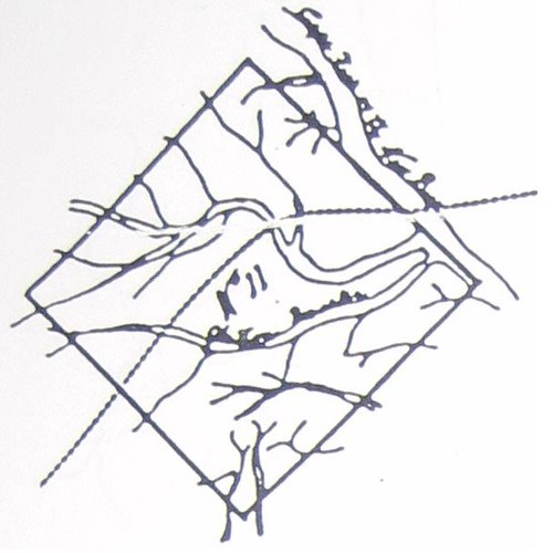
[If you are missing part of the picture on the east, you can click through to see the complete image.]
As shown, the diamond shaped Tract 11 does not appear to include land on the east side of the Haw River. However, the drawing cannot be taken literally, as the land and rivers are very schematic, not to scale.
According to Fred Hughes, the western extremity of this massive tract just about touched the old Rowan/Orange County line on the west. A 100,000 acre square is exactly 12.5 miles on a side and relying on Fred Hughes’s Historical Documentation: Guilford County, I measure (using Google Earth) that Tract #11 cut across the Haw River into a slice of the Lovick Tract, just missing any part of the Little Tract – which if correct would put the Swepsonville millsite distinctly outside Tract 11, though just barely.
However this would be a troubling conclusion. All of the documents involved in selling the mill from John Armstrong to John Trousdale show that the underlying title was Henry Eustace McCulloh’s. An agreement in the Armstrong Papers at the Southern Historical Collection shows that in July 1764 Armstrong agreed to build a saw mill and operate it. He was to pay 50 pounds a year to Henry Eustace McCulloh and at the end of 4 years McCulloh was to deed him a 1/2 undivided interest in the mill. This seems to have transpired as planned and McCulloh and Armstrong jointly sold the mill to John Trousdale only a few years after Armstrong's 50% interest vested. Yet the Armstrong/Trousdale mill site seems to be just north of the McCulloh line, putting it outside of McCulloh's Great Tract #11.
Land Grants on the West Bank
In order to more precisely fix McCulloh's S45E line as it intersected the Haw River, let's take a look at the Granville grants for that area (Granville's records being far more complete than McCulloh's).
John Campbell
This 1761 Granville grant to John Campbell is an obvious place to start:
The textual description of this tract refers to the S45E line here as “a line called McCullock’s” and the survey clearly shows one of the Trading Path fords on the Haw River. An important question, then, is which ford on the Haw this was. As I will show in a moment, this was definitely the ford at Swepsonville.
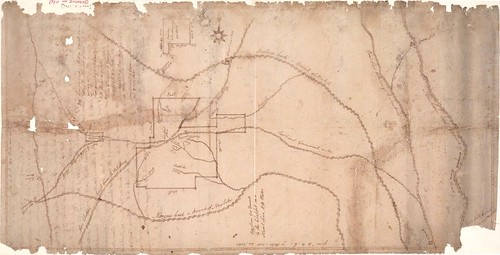
Conrod Long
Another interesting grant in that area is Orange Co. State Land Grant #167 to Conrod Long (below). Long's State Grant was dated 1779, but he was probably on this property much earlier. As the survey clearly shows Nelson Branch ran through and just off the south edge of this property.
My Historical Atlas of the Haw River says “John Hopkins, Samuel Shaw and William Galbreath all ran ferries near the mouth of Back Creek (Orange Court of Pleas and Quarter Session Minutes for May 1780, Feb 1783, May 1783 and Feb 1784).” I didn’t cite it in the Atlas, but there are deeds from Hopkins to Shaw conveying two parcels on opposite sides of the Haw River, recorded at Deed Book 2, pg 363 and 364 (1783). The deed for the west side of the Haw (page 364) reads “begin at a sweet gum on Nelsons Creek . . .” demonstrating that Nelson's Creek or Branch is the creek directly opposite the mouth of Back Creek. Using that reference point and the Conrod Long grant, we can sketch Mr. Long's farm onto a modern topo map.
William Phillips
Conrod Long’s grant indicates that the property owner to the south of him was named Phillips. This appears to have been William Phillips, who received a Granville grant in 1761 for 700 acres on the west side of the Haw (#538). The accompanying survey (shown below) plainly shows a creek flowing into the Haw, but neither the survey nor the legal description mentions the name.
I assume that this is Nelson Creek as shown on the Conrod Long grant and that William Phillips is the Phillips mentioned in the legal description of Long's grant. It is also notable that the 1761 grant to John Campbell refers to the property owner to the north as being Phillips. Note also that Campbell’s northern line was 81 chains from the Haw River due west to McCulloh’s line and Phillips southern boundary was also 81 chains due west from the Haw (and the next call of Phillips’s deed is N45W – a perfect match to McCulloh’s line, although McCulloh is not mentioned in the Phillips grant).
Putting It All Together
Thus, Conrod Long was just north of Nelson Branch. To the south of Long was William Phillips straddling the mouth of Nelson Branch, directly opposite Galbreath and Hopkins at the mouth of Back Creek. And to the south of Phillips was John Campbell. Mapping all three of these land grants together, it is clear that John Campbell’s grant was immediately opposite what would later be the textile mill in Swepsonville, with his southernmost corner being about 15 chains above the confluence of Big Alamance Creek and the Haw. Thus it would seem that the McCulloh line intersected the Haw River immediately south of the mill site at Swepsonville, rather nicely corroborating the result I got from projecting the location based on Historical Documentation: Guilford County.
The Mill Petitions
The Orange Court of Pleas and Quarter Sessions minutes for August 1761 record that John Campbell petitioned for permission to build a gristmill on the Haw River – just a few weeks before Campbell received his grant from Granville on 8/23/1761. However, notably Campbell’s mill petition was rejected and he gave notice of appeal to Halifax Court. It would be interesting to see if Halifax Court records of this case still exist.
In August 1763, the Orange Court of Pleas minutes show that Henry Eustace McCulloh condemned land of Robert Nugent in order to build a mill on the Haw River opposite land owned by McCulloh. My interpretation is that this petition relates to the same site as John Campbell's petition and that Henry Eustace McCulloh was a successor in interest to Campbell. This seems especially plausible because John Campbell was one of Henry McCulloh's agents in North Carolina. Henry spent most of his time in England and transacted business in North Carolina through some close associates to whom he granted Powers of Attorney. The surviving POA's name Henry's son Henry Eustace McCulloh, Alexander McCulloh and John Campbell (5 Colonial Records of North Carolina 779-782; 6 CR 532-536).
In other words, I think John Campbell obtained his Granville grant on behalf of Henry McCulloh (or Henry Eustace McCulloh) and merely held the property in trust for him; that might sound like an odd arrangement today, but it was a common method of operation for the McCullohs. All of this would explain how Henry Eustace McCulloh came to sell John Trousdale a mill site just outside of Tract 11.
Robert Nugent
This theory has left me with another curious question: Who was the Robert Nugent from whom McCulloh was condemning land? He must have owned the land that later became the Armstorng/Butler Tract - the east bank of the Haw at the Swepsonville mill site. But the Orange County Deed Books show no deeds to or from Robert Nugent - or any Nugent for that matter. Neither does the name Nugent appear in William D. Bennett's index of Orange land records (which includes the Granville papers). In fact, I cannot find any sign of Robert Nugent in any source related to 18th century Orange County.
The only clue I have come across is that there was a Robert Nugent in England who was oneo fthe Lords of Treasury in 1754. Perhaps Robert Nugent was the person who obtained supposed title to the Forster, Little and Lovick Tracts from former Gov. George Burrington. Burrington had nominally owned 40,000 acres in the Hawfields just east of Tract 11, but only 30,000 acres of that passed to Samuel Strudwick. The title to the other 10,000 acres has never been accounted for, although the area where that 10,000 acres lies is along the Haw River between the mouths of Back Creek and Big Alamance Creek - in other words all around Swepsonville.
James Stockard
The land on the west bank of the Haw above Alamance Creek eventually escheated to the University of North Carolina and was sold to James Stockard:
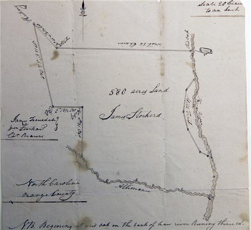
Stockard's 580 acres here includes almost all of the 1761 John Campbell grant (exceptin part carved out for 'the mill tract') as well as a a part of Tract 11. Notably Stockard's deed mentions that the property owner to the north is Phillips, quite consistent with our interpretation of the location of the Campbell grant. Much of this property eventually became a part of Archibald Debow Murphey's estate, The Hermitage.
[If you are missing part of the picture on the east, you can click through to see the complete image.]
As shown, the diamond shaped Tract 11 does not appear to include land on the east side of the Haw River. However, the drawing cannot be taken literally, as the land and rivers are very schematic, not to scale.
According to Fred Hughes, the western extremity of this massive tract just about touched the old Rowan/Orange County line on the west. A 100,000 acre square is exactly 12.5 miles on a side and relying on Fred Hughes’s Historical Documentation: Guilford County, I measure (using Google Earth) that Tract #11 cut across the Haw River into a slice of the Lovick Tract, just missing any part of the Little Tract – which if correct would put the Swepsonville millsite distinctly outside Tract 11, though just barely.
However this would be a troubling conclusion. All of the documents involved in selling the mill from John Armstrong to John Trousdale show that the underlying title was Henry Eustace McCulloh’s. An agreement in the Armstrong Papers at the Southern Historical Collection shows that in July 1764 Armstrong agreed to build a saw mill and operate it. He was to pay 50 pounds a year to Henry Eustace McCulloh and at the end of 4 years McCulloh was to deed him a 1/2 undivided interest in the mill. This seems to have transpired as planned and McCulloh and Armstrong jointly sold the mill to John Trousdale only a few years after Armstrong's 50% interest vested. Yet the Armstrong/Trousdale mill site seems to be just north of the McCulloh line, putting it outside of McCulloh's Great Tract #11.
Land Grants on the West Bank
In order to more precisely fix McCulloh's S45E line as it intersected the Haw River, let's take a look at the Granville grants for that area (Granville's records being far more complete than McCulloh's).
John Campbell
This 1761 Granville grant to John Campbell is an obvious place to start:
The textual description of this tract refers to the S45E line here as “a line called McCullock’s” and the survey clearly shows one of the Trading Path fords on the Haw River. An important question, then, is which ford on the Haw this was. As I will show in a moment, this was definitely the ford at Swepsonville.
Conrod Long
Another interesting grant in that area is Orange Co. State Land Grant #167 to Conrod Long (below). Long's State Grant was dated 1779, but he was probably on this property much earlier. As the survey clearly shows Nelson Branch ran through and just off the south edge of this property.
My Historical Atlas of the Haw River says “John Hopkins, Samuel Shaw and William Galbreath all ran ferries near the mouth of Back Creek (Orange Court of Pleas and Quarter Session Minutes for May 1780, Feb 1783, May 1783 and Feb 1784).” I didn’t cite it in the Atlas, but there are deeds from Hopkins to Shaw conveying two parcels on opposite sides of the Haw River, recorded at Deed Book 2, pg 363 and 364 (1783). The deed for the west side of the Haw (page 364) reads “begin at a sweet gum on Nelsons Creek . . .” demonstrating that Nelson's Creek or Branch is the creek directly opposite the mouth of Back Creek. Using that reference point and the Conrod Long grant, we can sketch Mr. Long's farm onto a modern topo map.
William Phillips
Conrod Long’s grant indicates that the property owner to the south of him was named Phillips. This appears to have been William Phillips, who received a Granville grant in 1761 for 700 acres on the west side of the Haw (#538). The accompanying survey (shown below) plainly shows a creek flowing into the Haw, but neither the survey nor the legal description mentions the name.
I assume that this is Nelson Creek as shown on the Conrod Long grant and that William Phillips is the Phillips mentioned in the legal description of Long's grant. It is also notable that the 1761 grant to John Campbell refers to the property owner to the north as being Phillips. Note also that Campbell’s northern line was 81 chains from the Haw River due west to McCulloh’s line and Phillips southern boundary was also 81 chains due west from the Haw (and the next call of Phillips’s deed is N45W – a perfect match to McCulloh’s line, although McCulloh is not mentioned in the Phillips grant).
Putting It All Together
Thus, Conrod Long was just north of Nelson Branch. To the south of Long was William Phillips straddling the mouth of Nelson Branch, directly opposite Galbreath and Hopkins at the mouth of Back Creek. And to the south of Phillips was John Campbell. Mapping all three of these land grants together, it is clear that John Campbell’s grant was immediately opposite what would later be the textile mill in Swepsonville, with his southernmost corner being about 15 chains above the confluence of Big Alamance Creek and the Haw. Thus it would seem that the McCulloh line intersected the Haw River immediately south of the mill site at Swepsonville, rather nicely corroborating the result I got from projecting the location based on Historical Documentation: Guilford County.
The Mill Petitions
The Orange Court of Pleas and Quarter Sessions minutes for August 1761 record that John Campbell petitioned for permission to build a gristmill on the Haw River – just a few weeks before Campbell received his grant from Granville on 8/23/1761. However, notably Campbell’s mill petition was rejected and he gave notice of appeal to Halifax Court. It would be interesting to see if Halifax Court records of this case still exist.
In August 1763, the Orange Court of Pleas minutes show that Henry Eustace McCulloh condemned land of Robert Nugent in order to build a mill on the Haw River opposite land owned by McCulloh. My interpretation is that this petition relates to the same site as John Campbell's petition and that Henry Eustace McCulloh was a successor in interest to Campbell. This seems especially plausible because John Campbell was one of Henry McCulloh's agents in North Carolina. Henry spent most of his time in England and transacted business in North Carolina through some close associates to whom he granted Powers of Attorney. The surviving POA's name Henry's son Henry Eustace McCulloh, Alexander McCulloh and John Campbell (5 Colonial Records of North Carolina 779-782; 6 CR 532-536).
In other words, I think John Campbell obtained his Granville grant on behalf of Henry McCulloh (or Henry Eustace McCulloh) and merely held the property in trust for him; that might sound like an odd arrangement today, but it was a common method of operation for the McCullohs. All of this would explain how Henry Eustace McCulloh came to sell John Trousdale a mill site just outside of Tract 11.
Robert Nugent
This theory has left me with another curious question: Who was the Robert Nugent from whom McCulloh was condemning land? He must have owned the land that later became the Armstorng/Butler Tract - the east bank of the Haw at the Swepsonville mill site. But the Orange County Deed Books show no deeds to or from Robert Nugent - or any Nugent for that matter. Neither does the name Nugent appear in William D. Bennett's index of Orange land records (which includes the Granville papers). In fact, I cannot find any sign of Robert Nugent in any source related to 18th century Orange County.
The only clue I have come across is that there was a Robert Nugent in England who was oneo fthe Lords of Treasury in 1754. Perhaps Robert Nugent was the person who obtained supposed title to the Forster, Little and Lovick Tracts from former Gov. George Burrington. Burrington had nominally owned 40,000 acres in the Hawfields just east of Tract 11, but only 30,000 acres of that passed to Samuel Strudwick. The title to the other 10,000 acres has never been accounted for, although the area where that 10,000 acres lies is along the Haw River between the mouths of Back Creek and Big Alamance Creek - in other words all around Swepsonville.
James Stockard
The land on the west bank of the Haw above Alamance Creek eventually escheated to the University of North Carolina and was sold to James Stockard:
Stockard's 580 acres here includes almost all of the 1761 John Campbell grant (exceptin part carved out for 'the mill tract') as well as a a part of Tract 11. Notably Stockard's deed mentions that the property owner to the north is Phillips, quite consistent with our interpretation of the location of the Campbell grant. Much of this property eventually became a part of Archibald Debow Murphey's estate, The Hermitage.
Saturday, January 23, 2010
Carrboro: From Forest to Mill Village and Beyond - Historical Geography, City Planning and Sense of Place
The following is more or less the presentation I gave at the UNC Geography Department's Spring Colloquium series (Jan 24, 2010):
This afternoon, I want to tell you the story of the historical landscape of Carrboro, but while doing so, I will have to address the historical landscape of Chapel Hill. So let’s begin right here where I am standing.
Before Carrboro, before Chapel Hill, before UNC, before the State of North Carolina, there was a chapel - an Anglican chapel of ease, which was a respite for travellers. It was called New Hope Chapel, after the creek into whose waters it drained. One of the first state land grants in Orange County was to Mark Morgan for the "Chapel Tract," so the chapel was definitely built before 1778 - probably during the administration of colonial Governor Gabriel Johnston. In any case, the chapel was where the south end of the Carolina Inn is now.

Mark Morgan's Chapel Tract was soon divided up and sold to a handful of local farmers. In 1792, UNC's original campus was donated to the University by these same Chapel Hill area farmers who thought that having a University around here would bring property values up (a point upon which they have been suitably vindicated). One of the donors was Kit Barbee and I am standing on the land he gave right now as I give this talk. Other donors gave parcels that were nearby but not contiguous, for example the seldom noted Alexander Piper, who gave a 20 acre tract of land about a mile west of what became UNC (ODB 5, pg 614).
Piper’s grant is shown plainly on the 1792 Daniel map of UNC's lands, the first detailed map of this area. The second map of this area is the 1795 Plan of the Situation of Ye University, which is the oldest existing map showing the location of the streets in Chapel Hill. Here is the intersection of Franklin and Columbia.
I got to wondering just where the Piper Donation was, so I made a bit of a mash up of the 1795 Plan of the Situation, the 1792 Daniel Map, and the 2009 Orange County GIS tax maps, tying together the dog leg western boundary of the campus, the lots at the corner of Franklin and Columbia Street and the position of the Patterson Donation shown on the Daniel map. The result is very interesting:
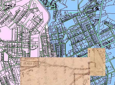
The Piper Donation was what would later become Downtown Carrboro. The tract appears to have run from the rail line on the east to Oak Avenue on the west and from Weaver Street south to the south edge of the lots along Main Street. The Orange Co Tax Assessor currently values the Piper Donation at about $20 Million.
![6 Piper_Donation[1]](http://farm3.static.flickr.com/2689/4297026797_9c832c9ea1.jpg)
Of course, back in 1792, there was not that much there in terms of development. Two roads ran through the property. The north fork was essentially what is now Weaver Street, turning northward and following Main Street, and then Hillsborough Road to Hillsborough. The south fork led to McCauley's Mill, a grist mill that stood about where University Lake dam is now; no modern road really tracks that course.
UNC sold off this future $20 Million in real estate in 1837 to John M Craig for $40 (ODB 28, pg 272). Thirty years later, Craig's estate sold a larger parcel to William L Saunders – apparently the same vicinity: "lying on the western outskirts of Chapel Hill upon both sides of the road leading from Chapel Hill to Greensboro adjoining the lands of John Weaver, Thomas Weaver, and others and bounded as follows: Beginning at the mud hole in Craigs Lane upon said Road running thence . . . to a locust on the road leading to Greensboro [now North Greensboro Street] then . . . to a rock in the road from Chapel Hill to Jones Ford on Haw River [Jones Ferry Road] thence E with the said Road” (ODB 39, pg 312). Saunders sold exactly the same property to Chapel Hill merchants Henry H Patterson and Fendal S Hogan in 1879 (ODB 46, pg 257). That 101 ½ acres became most of downtown Carrboro.
The Railroad
Notably, 1879 was quite a propitious year in which to have bought that land, as the State University Rail Road was just getting reorganized and preparing to actually build a rail line this time around – which they actually completed in 1882. In the middle of Patterson’s 101 ½ acres was where the rail line terminated – right where it reached the road leading to Hillsborough, Greensboro, and points westward. That extension of Rosemary Street in Chapel Hill, the street at which the railhead stopped, came to be called Main Street.
You will commonly hear it said that Carrboro grew up where it did because the railroad was prohibited from coming within one mile of the University campus. That is not correct. There was no statute from the Legislature nor any corporate charter provision nor any decision of the UNC Board of Trustees requiring that the railhead keep away from the campus. Quite the reverse of the claims of some, the Trustees were not at all shy about the railroad; they lobbied the legislature to get the use of convict labor for construction. And it appears that the project needed cheap labor as it was seriously underfunded and only barely got built.
Various alternative routes were considered in 1879 and the most promising two were the route that was actually built from Carrboro to University Station on the North Carolina Railroad and a route that would have run more or less along what is now 15-501 to the rail line in Durham. It is interesting to contemplate for a moment how different our community would be if that rail line had been built to Durham. However, the line to Durham was more expensive; without adequate investment from Durham businessmen, the shorter and cheaper route to University Station had to be used. Gen. Hoke's iron mine offered to provide the steel, which sealed the deal for the route that came by the iron mine to the west end of Chapel Hill.
That iron mine is now the Ironwoods neighborhood in Chapel Hill.
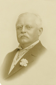
Durham industrialist and UNC benefactor Julian Shakespeare Carr was bitterly opposed to the route to University Station.
Carr wanted the line to come to Durham, but could not convince enough of his business associates in Durham to invest in the project. Carr wrote a letter to The Chapel Hill Ledger (1/24/1880) casting doubt on the success of a route that did not connect at Durham: “I trust that your railroad to University Station may prove of as much benefit to the good people of Chapel Hill as some of your very clever citizens seem to think it will, but, to be honest with you, I have very little hope of it myself.” As it turned out, the railroad to University Station was not only a benefit to “the good people of Chapel Hill,” but it was so successful that it spawned a new town that would, thirty-three years later, be named after Julian Shakespeare Carr.
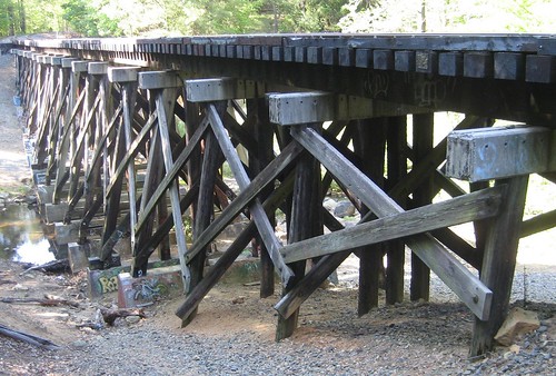
Twice during construction, the State University Railroad Company nearly went bankrupt and the whole mess was only barely saved by the intervention of the Richmond and Danville Railroad. In performing this bailout, the R&DRR entered into an agreement with the State University Railroad. The SURR was to complete the grading and the R&DRR would install the rails and provide the rolling stock. However, a misunderstanding arose between the two companies because each had expected the other to build the trestles over New Hope and Bolin Creeks. Ultimately the R&DRR went ahead and built the trestles, but consequently cut the budget somewhere else.
The written agreement is recorded in Hillsborough (ODB) and it explicitly states that the R&DRR was to complete the rail line "to the Town Line." But instead they stopped about 1/2 mile short of Merritt Mill Road where the town line was then and is now. So, realistically the most likely thing appears that the railhead is where it is because that was as close as they could get with the desperately strapped budget they had and everyone concluded that that was close enough. Also, the area that is now downtown Carrboro afforded a large flat area in which to build the wye.
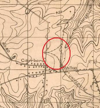
The wye was the triangular rail configuration that allowed the engine to turn around. Two thirds of the wye still exists, the main line and the spur leading into the Fitch parking lot.
The Cotton and Hosiery Mills
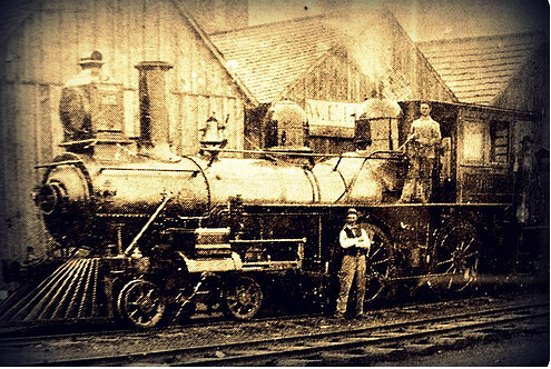
12 [Slide of Lloyd Grist Mill]
Almost immediately after the railroad was complete, Thomas F. Lloyd built a steam powered gristmill and cotton gin next to the railhead in 1883. This building, which in recent years has been called the Broad Street Building, still stands near the northeast corner of the intersection of Main Street and the railroad tracks.
14 [Slide of Carr Mill]
In the northwest corner of the intersection Lloyd built a cotton and hosiery mill in 1898, creating an industry that Carrboro was built on.
That site is still the focal point of the community today.
Dr. John Florin co-authored an excellent narrative of the history of this phase of mill development as a preface to Carrboro, NC: An architectural and historical inventory, which I will not attempt to compete with.
After 10 years, Lloyd sold his Alberta Cotton Mill to Julian Shakespeare Carr. Carr also purchase another smaller mill that stood where Fitch lumber Co is today. Lloyd immediately set about building yet another mill (now gone) just south of the Alberta Mill. The textile industry was good to Carrboro for many years, but by the mid-1950’s Pacific Woolen Mills, the successors to Carr, closed shop for good.
During the golden age of mill development in Carrboro, many houses were built by the mill owners in order to supply their own workers with housing, much as was the case in mill villages across the South. And in this way, the old mill village of Carrboro grew largely the same way that many other company towns did. However by the time of the Depression business trends wandered away from the mill owner as residential landlord; the free market seemed to be a simpler way to address the mill worker housing problem. In 1939, the mills sold off most of Carrboro’s mill houses.
The relative flatness of downtown Carrboro was particularly helpful for laying out a rectilinear street grid initially:
But as with the old parts of Chapel Hill, as the street grid ran into topographic challenges, the grid was abandoned.
Also, later trends in city planning led away from street grids.
By 1969, the municipal boundaries of Carrboro encompassed about twice the area of the original municipal boundaries.
And then the Aldermen got a big idea.

They started approving large apartment complexes along the NC-54 Bypass in order to gain taxbase, mostly on the backs of UNC students who were no kind of political factor in Carrboro. However ultimately this theory backfired. As more and more students and recent graduates moved to Carrboro, they became a significant political force, especially with relation to the creation of Chapel Hill Transit, as well as the initiation of a policy requiring sidewalks in new developments, among numerous other environmental initiatives. Also, the 26th amendment lowered the voting age to 18 in 1972 and within a decade the students, hippies and recent graduates had taken over Carrboro town government.
This new school of Carrboro politics came along at the same time that a proposal surfaced to tear down the abandoned Pacific Woolen Mills, formerly Durham Hosiery Mill #5, the mill that Thomas Lloyd sold to Julian Shakespeare Carr, that place from which our community takes its name. A coalition of people came together including many new and old residents of Carrboro to oppose the demolition and eventually convinced a group of investors to step in and save the building, in part using a federal grant that came through the Town of Carrboro.
The combination of the political movement that initiated bus service in Carrboro and the local coalition that saved the historic mill building formed the foundation of modern politics in Carrboro – a paradigm that has its roots in the early 1970’s planning decisions made by the Board of Aldermen.
This was, of course, the furthest thing from the minds of the Carrboro born and bred men who made up the Board in the early 1970’s. I cannot help but wonder whether we are presently undergoing the same process, but in reverse. As more and more extremely expensive housing is built in suburban Carrboro, I wonder whether this will eventually change the character of our town.
Landscape and Memory
Having brought you more or less up to the present, it seems appropriate to move on to a discussion of the future of Carrboro, but before we go there, we need to discuss a curious aspect of life in Carrboro and Chapel Hill.
It has sometimes been said that everyone seems to think that Chapel Hill was perfect right about the time they got there. Along those lines, R. L. Gray in his 1904 essay on Chapel Hill wrote (from the News & Observer reprinted in NC Journal of Law, Vol 1, pp 516-518, 1904):
"Let the man have been tarred with the University stick and he will tell you along with his after-dinner cigar that he has a notion of some day building a house at Chapel Hill – and there remain to the end of the chapter in the one place where he believes he can obtain a large and perfect peace. There men cling to the town and its surroundings with a memory that is both tenacious and jealous of details.
"A friend was describing to one of these - a graduate before the [Civil] war – the site of the present Alumni Building. Suddenly the old graduate’s eyes flashed fire: “What!” he exclaimed. “You don’t tell me they’ve cut down the old college linden! I’d rather they’d have gone without that building forever than that they should have touched that tree!
"And so it goes. Living in the hearts of its scattered children, each tree shrub and rose bush, almost each stone of its serried ranks of rough built walls, bears its own faint story; and it is the indefinable suggestion that seems in time to float out from the inanimate things that have brushed on human hopes that strangely strikes the newcomer at the moment he places foot upon the campus and brings to the returned a tingling of the blood and a half forgotten smell of the air that at once exhilarate and recall to half sad dreams of bygone days."
Gray’s argument is essentially that the landscape of Chapel Hill is a part of the experience of being young and full of life in Chapel Hill. Revisiting the landscape of your young adulthood brings back fond memories of days gone by. Or in other words, there’s nothing like walking down Franklin Street to make you feel young again. And any change at UNC (or in Chapel Hill) detracts from that feeling.
Gray’s theory explains the experience of returning alumni, who for example are sometimes crestfallen to find that the Rathskeller is no more, or similarly are shocked to see Greenbridge rising on Chapel Hill’s western border. I am not sure that the experience is exactly the same for those who live in and near Chapel Hill and return to UNC and downtown on a regular basis, but it is at least part of that story.
Gray makes no remark on Carrboro in part because the village scarcely existed in 1904, but Carrboro is not immune to this same issue. Probably the greatest challenge facing our town is how our downtown can grow without compromising the sense of place that is Carrboro. And I suppose such things are challenges for any community, but I think Gray is suggesting that this phenomenon is especially strong in Chapel Hill because so many people discover the town as 18-year-olds, entering the prime of life and for the first time living with new found freedom. This is true for Carrboro as well, although somewhat less so because Carrboro is less a part of the undergraduate experience for most students.
As an aside, I love the detail that the fierce critic of change in Gray’s essay “has a notion of some day building a house at Chapel Hill.” Just one more house won’t hurt, as long as it is mine. From today’s vantage point, it also seems ironic that the critic would lament the construction of Alumni Hall:
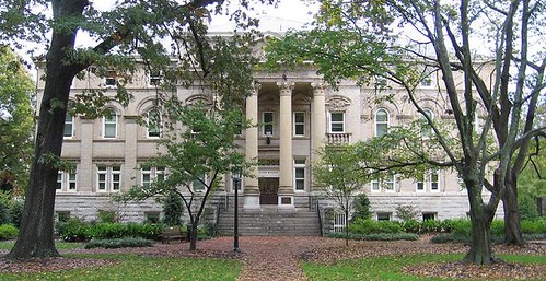
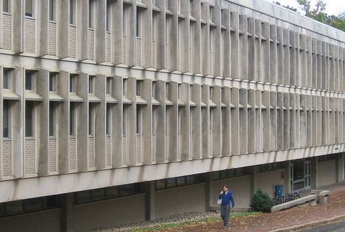
Alumni Hall is one of the buildings that gives secondary definition to McCorkle Place and has many beautiful architectural details. That anti-Alumni Hall sentiment seems particularly ironic in light of Davie Hall, which UNC went on to build only 200 yards away:
The desire to return to a Chapel Hill that was known from earlier days goes still further back in UNC's history. William D. Moseley, a member of the UNC class of 1818, wrote a letter to his former professor Elisha Mitchell in 1853: “I know of no earthly pleasure which would afford me more heartfelt satisfaction than a short stay at that village [Chapel Hill]; where I could again refresh my memory with a review of the places and things that still remain as mementos of days that are past; when the future was looked to with hopes, never to be realized.”
And I must give credit where it is due, UNC has been creative in preserving some aspects of the historical landscape. Among Moseley’s other comments in his 1853 letter: “I would like too to visit the Old Poplar, in the right of the path leading from the Chapel to Dr Caldwell's. Is it still living?”


Not only was it still living in 1853, but it is still living today:
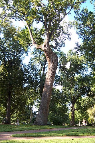
Moseley’s letter indicates that the Davie Poplar was a noted landmark even when the University was young. And clearly it was called “the Old Poplar” even by members of the class of 1818. It was already at least 100 years old when Moseley graduated. The Davie Poplar is now at least 300 years old and some think it may be approaching 400.
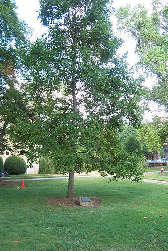
But nothing in this world lasts forever, and UNC began preparing for the inevitable about 90 years ago by grafting a cutting of the Davie Poplar to create Davie Poplar, Jr., which grows in the shadows of the original. And more recently a seedling of the Davie Poplar was cultivated and planted nearby with the appellation Davie Poplar, III. It's right in front of Alumni Hall as it happens. Maybe they could replant a college linden there? While obviously no one is hoping for the day when the Davie Poplar falls, it is reassuring to know that UNC has long since begun to prepare for that day.
Likewise, no one hopes for the day when our community will face dramatic changes brought about by greenhouse gasses as well as the ever-increasing cost (and ever-decreasing supply) of petroleum. But we cannot bury our heads in the sand and hope that such challenges will never come. At the local level, Carrboro, UNC and Chapel Hill can make only the most incremental changes to the composition of the atmosphere or the supply of available petroleum. But we can and we must prepare for the future that we know is coming.
Preparing for a world with fewer cars and less petroleum will partly involve technological breakthroughs in sustainable energy, but it must also involve dramatic improvements in energy efficiency. And one way for us to reduce our society’s demand for energy - a way that is entirely within the control of local government in North Carolina - is to change our built landscape – to create a more pedestrian, bicycle and transit friendly landscape. And that will involve a more compact form of development, focused on key transportation corridors.
One area that is appropriate for the new landscape that our community will need is the NC 54 corridor between Meadowmont and UNC, along the planned route of the Triangle’s light-rail system. Downtown Carrboro and downtown Chapel Hill are also areas where outstanding public transportation is already readily available and are appropriate places for more intense development. Yet, the importance of the landscape, the sense of place in these locations cannot be ignored.
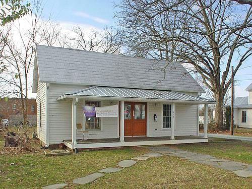
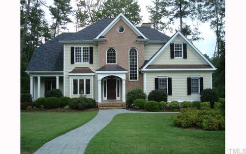
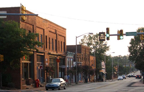
How would Carrboro be Carrboro without these buildings:
On the other hand, some downtown Carrboro buildings seem considerably less essential:
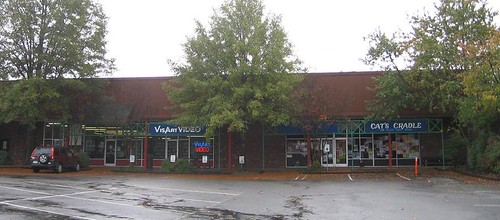
To be clear these businesses are essential, but the buildings are not.
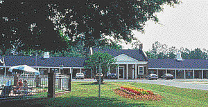
Likewise, the Best Western University Inn was a pretty unremarkable building. The grassy areas out front were pleasant, but it was mostly a low utilitarian building with a sea of asphalt in front. The picture above was taken as a publicity photo and it still makes the building and lot look unremarkable (at best). East54's critics only ever acknowledge this reality when prompted to do so. Likewise there seems to be no public acknowledgement that the site of Greenbridge was not long ago a flophouse for crack dealers. Does any of this mean that East54, Greenbridge or 300 E. Main Street will be perfect? Of course not. But let’s be clear, what they are replacing was not so terrific as some would like to pretend.
Change is inevitable for Carrboro and Chapel Hill. The challenge is to keep the elements that are central to our landscape from the past, while creating a more energy-efficient and pedestrian friendly landscape for the future. Personally, I think that is something that Carrboro, UNC and Chapel Hill can do.
This afternoon, I want to tell you the story of the historical landscape of Carrboro, but while doing so, I will have to address the historical landscape of Chapel Hill. So let’s begin right here where I am standing.
Before Carrboro, before Chapel Hill, before UNC, before the State of North Carolina, there was a chapel - an Anglican chapel of ease, which was a respite for travellers. It was called New Hope Chapel, after the creek into whose waters it drained. One of the first state land grants in Orange County was to Mark Morgan for the "Chapel Tract," so the chapel was definitely built before 1778 - probably during the administration of colonial Governor Gabriel Johnston. In any case, the chapel was where the south end of the Carolina Inn is now.
Mark Morgan's Chapel Tract was soon divided up and sold to a handful of local farmers. In 1792, UNC's original campus was donated to the University by these same Chapel Hill area farmers who thought that having a University around here would bring property values up (a point upon which they have been suitably vindicated). One of the donors was Kit Barbee and I am standing on the land he gave right now as I give this talk. Other donors gave parcels that were nearby but not contiguous, for example the seldom noted Alexander Piper, who gave a 20 acre tract of land about a mile west of what became UNC (ODB 5, pg 614).
Piper’s grant is shown plainly on the 1792 Daniel map of UNC's lands, the first detailed map of this area. The second map of this area is the 1795 Plan of the Situation of Ye University, which is the oldest existing map showing the location of the streets in Chapel Hill. Here is the intersection of Franklin and Columbia.
I got to wondering just where the Piper Donation was, so I made a bit of a mash up of the 1795 Plan of the Situation, the 1792 Daniel Map, and the 2009 Orange County GIS tax maps, tying together the dog leg western boundary of the campus, the lots at the corner of Franklin and Columbia Street and the position of the Patterson Donation shown on the Daniel map. The result is very interesting:
The Piper Donation was what would later become Downtown Carrboro. The tract appears to have run from the rail line on the east to Oak Avenue on the west and from Weaver Street south to the south edge of the lots along Main Street. The Orange Co Tax Assessor currently values the Piper Donation at about $20 Million.
Of course, back in 1792, there was not that much there in terms of development. Two roads ran through the property. The north fork was essentially what is now Weaver Street, turning northward and following Main Street, and then Hillsborough Road to Hillsborough. The south fork led to McCauley's Mill, a grist mill that stood about where University Lake dam is now; no modern road really tracks that course.
UNC sold off this future $20 Million in real estate in 1837 to John M Craig for $40 (ODB 28, pg 272). Thirty years later, Craig's estate sold a larger parcel to William L Saunders – apparently the same vicinity: "lying on the western outskirts of Chapel Hill upon both sides of the road leading from Chapel Hill to Greensboro adjoining the lands of John Weaver, Thomas Weaver, and others and bounded as follows: Beginning at the mud hole in Craigs Lane upon said Road running thence . . . to a locust on the road leading to Greensboro [now North Greensboro Street] then . . . to a rock in the road from Chapel Hill to Jones Ford on Haw River [Jones Ferry Road] thence E with the said Road” (ODB 39, pg 312). Saunders sold exactly the same property to Chapel Hill merchants Henry H Patterson and Fendal S Hogan in 1879 (ODB 46, pg 257). That 101 ½ acres became most of downtown Carrboro.
The Railroad
Notably, 1879 was quite a propitious year in which to have bought that land, as the State University Rail Road was just getting reorganized and preparing to actually build a rail line this time around – which they actually completed in 1882. In the middle of Patterson’s 101 ½ acres was where the rail line terminated – right where it reached the road leading to Hillsborough, Greensboro, and points westward. That extension of Rosemary Street in Chapel Hill, the street at which the railhead stopped, came to be called Main Street.
You will commonly hear it said that Carrboro grew up where it did because the railroad was prohibited from coming within one mile of the University campus. That is not correct. There was no statute from the Legislature nor any corporate charter provision nor any decision of the UNC Board of Trustees requiring that the railhead keep away from the campus. Quite the reverse of the claims of some, the Trustees were not at all shy about the railroad; they lobbied the legislature to get the use of convict labor for construction. And it appears that the project needed cheap labor as it was seriously underfunded and only barely got built.
Various alternative routes were considered in 1879 and the most promising two were the route that was actually built from Carrboro to University Station on the North Carolina Railroad and a route that would have run more or less along what is now 15-501 to the rail line in Durham. It is interesting to contemplate for a moment how different our community would be if that rail line had been built to Durham. However, the line to Durham was more expensive; without adequate investment from Durham businessmen, the shorter and cheaper route to University Station had to be used. Gen. Hoke's iron mine offered to provide the steel, which sealed the deal for the route that came by the iron mine to the west end of Chapel Hill.
That iron mine is now the Ironwoods neighborhood in Chapel Hill.
Durham industrialist and UNC benefactor Julian Shakespeare Carr was bitterly opposed to the route to University Station.
Carr wanted the line to come to Durham, but could not convince enough of his business associates in Durham to invest in the project. Carr wrote a letter to The Chapel Hill Ledger (1/24/1880) casting doubt on the success of a route that did not connect at Durham: “I trust that your railroad to University Station may prove of as much benefit to the good people of Chapel Hill as some of your very clever citizens seem to think it will, but, to be honest with you, I have very little hope of it myself.” As it turned out, the railroad to University Station was not only a benefit to “the good people of Chapel Hill,” but it was so successful that it spawned a new town that would, thirty-three years later, be named after Julian Shakespeare Carr.
Twice during construction, the State University Railroad Company nearly went bankrupt and the whole mess was only barely saved by the intervention of the Richmond and Danville Railroad. In performing this bailout, the R&DRR entered into an agreement with the State University Railroad. The SURR was to complete the grading and the R&DRR would install the rails and provide the rolling stock. However, a misunderstanding arose between the two companies because each had expected the other to build the trestles over New Hope and Bolin Creeks. Ultimately the R&DRR went ahead and built the trestles, but consequently cut the budget somewhere else.
The written agreement is recorded in Hillsborough (ODB) and it explicitly states that the R&DRR was to complete the rail line "to the Town Line." But instead they stopped about 1/2 mile short of Merritt Mill Road where the town line was then and is now. So, realistically the most likely thing appears that the railhead is where it is because that was as close as they could get with the desperately strapped budget they had and everyone concluded that that was close enough. Also, the area that is now downtown Carrboro afforded a large flat area in which to build the wye.
The wye was the triangular rail configuration that allowed the engine to turn around. Two thirds of the wye still exists, the main line and the spur leading into the Fitch parking lot.
The Cotton and Hosiery Mills
12 [Slide of Lloyd Grist Mill]
Almost immediately after the railroad was complete, Thomas F. Lloyd built a steam powered gristmill and cotton gin next to the railhead in 1883. This building, which in recent years has been called the Broad Street Building, still stands near the northeast corner of the intersection of Main Street and the railroad tracks.
14 [Slide of Carr Mill]
In the northwest corner of the intersection Lloyd built a cotton and hosiery mill in 1898, creating an industry that Carrboro was built on.
That site is still the focal point of the community today.
Dr. John Florin co-authored an excellent narrative of the history of this phase of mill development as a preface to Carrboro, NC: An architectural and historical inventory, which I will not attempt to compete with.
After 10 years, Lloyd sold his Alberta Cotton Mill to Julian Shakespeare Carr. Carr also purchase another smaller mill that stood where Fitch lumber Co is today. Lloyd immediately set about building yet another mill (now gone) just south of the Alberta Mill. The textile industry was good to Carrboro for many years, but by the mid-1950’s Pacific Woolen Mills, the successors to Carr, closed shop for good.
During the golden age of mill development in Carrboro, many houses were built by the mill owners in order to supply their own workers with housing, much as was the case in mill villages across the South. And in this way, the old mill village of Carrboro grew largely the same way that many other company towns did. However by the time of the Depression business trends wandered away from the mill owner as residential landlord; the free market seemed to be a simpler way to address the mill worker housing problem. In 1939, the mills sold off most of Carrboro’s mill houses.
The relative flatness of downtown Carrboro was particularly helpful for laying out a rectilinear street grid initially:
But as with the old parts of Chapel Hill, as the street grid ran into topographic challenges, the grid was abandoned.
Also, later trends in city planning led away from street grids.
By 1969, the municipal boundaries of Carrboro encompassed about twice the area of the original municipal boundaries.
And then the Aldermen got a big idea.
They started approving large apartment complexes along the NC-54 Bypass in order to gain taxbase, mostly on the backs of UNC students who were no kind of political factor in Carrboro. However ultimately this theory backfired. As more and more students and recent graduates moved to Carrboro, they became a significant political force, especially with relation to the creation of Chapel Hill Transit, as well as the initiation of a policy requiring sidewalks in new developments, among numerous other environmental initiatives. Also, the 26th amendment lowered the voting age to 18 in 1972 and within a decade the students, hippies and recent graduates had taken over Carrboro town government.
This new school of Carrboro politics came along at the same time that a proposal surfaced to tear down the abandoned Pacific Woolen Mills, formerly Durham Hosiery Mill #5, the mill that Thomas Lloyd sold to Julian Shakespeare Carr, that place from which our community takes its name. A coalition of people came together including many new and old residents of Carrboro to oppose the demolition and eventually convinced a group of investors to step in and save the building, in part using a federal grant that came through the Town of Carrboro.
The combination of the political movement that initiated bus service in Carrboro and the local coalition that saved the historic mill building formed the foundation of modern politics in Carrboro – a paradigm that has its roots in the early 1970’s planning decisions made by the Board of Aldermen.
This was, of course, the furthest thing from the minds of the Carrboro born and bred men who made up the Board in the early 1970’s. I cannot help but wonder whether we are presently undergoing the same process, but in reverse. As more and more extremely expensive housing is built in suburban Carrboro, I wonder whether this will eventually change the character of our town.
Landscape and Memory
Having brought you more or less up to the present, it seems appropriate to move on to a discussion of the future of Carrboro, but before we go there, we need to discuss a curious aspect of life in Carrboro and Chapel Hill.
It has sometimes been said that everyone seems to think that Chapel Hill was perfect right about the time they got there. Along those lines, R. L. Gray in his 1904 essay on Chapel Hill wrote (from the News & Observer reprinted in NC Journal of Law, Vol 1, pp 516-518, 1904):
"Let the man have been tarred with the University stick and he will tell you along with his after-dinner cigar that he has a notion of some day building a house at Chapel Hill – and there remain to the end of the chapter in the one place where he believes he can obtain a large and perfect peace. There men cling to the town and its surroundings with a memory that is both tenacious and jealous of details.
"A friend was describing to one of these - a graduate before the [Civil] war – the site of the present Alumni Building. Suddenly the old graduate’s eyes flashed fire: “What!” he exclaimed. “You don’t tell me they’ve cut down the old college linden! I’d rather they’d have gone without that building forever than that they should have touched that tree!
"And so it goes. Living in the hearts of its scattered children, each tree shrub and rose bush, almost each stone of its serried ranks of rough built walls, bears its own faint story; and it is the indefinable suggestion that seems in time to float out from the inanimate things that have brushed on human hopes that strangely strikes the newcomer at the moment he places foot upon the campus and brings to the returned a tingling of the blood and a half forgotten smell of the air that at once exhilarate and recall to half sad dreams of bygone days."
Gray’s argument is essentially that the landscape of Chapel Hill is a part of the experience of being young and full of life in Chapel Hill. Revisiting the landscape of your young adulthood brings back fond memories of days gone by. Or in other words, there’s nothing like walking down Franklin Street to make you feel young again. And any change at UNC (or in Chapel Hill) detracts from that feeling.
Gray’s theory explains the experience of returning alumni, who for example are sometimes crestfallen to find that the Rathskeller is no more, or similarly are shocked to see Greenbridge rising on Chapel Hill’s western border. I am not sure that the experience is exactly the same for those who live in and near Chapel Hill and return to UNC and downtown on a regular basis, but it is at least part of that story.
Gray makes no remark on Carrboro in part because the village scarcely existed in 1904, but Carrboro is not immune to this same issue. Probably the greatest challenge facing our town is how our downtown can grow without compromising the sense of place that is Carrboro. And I suppose such things are challenges for any community, but I think Gray is suggesting that this phenomenon is especially strong in Chapel Hill because so many people discover the town as 18-year-olds, entering the prime of life and for the first time living with new found freedom. This is true for Carrboro as well, although somewhat less so because Carrboro is less a part of the undergraduate experience for most students.
As an aside, I love the detail that the fierce critic of change in Gray’s essay “has a notion of some day building a house at Chapel Hill.” Just one more house won’t hurt, as long as it is mine. From today’s vantage point, it also seems ironic that the critic would lament the construction of Alumni Hall:
Alumni Hall is one of the buildings that gives secondary definition to McCorkle Place and has many beautiful architectural details. That anti-Alumni Hall sentiment seems particularly ironic in light of Davie Hall, which UNC went on to build only 200 yards away:
The desire to return to a Chapel Hill that was known from earlier days goes still further back in UNC's history. William D. Moseley, a member of the UNC class of 1818, wrote a letter to his former professor Elisha Mitchell in 1853: “I know of no earthly pleasure which would afford me more heartfelt satisfaction than a short stay at that village [Chapel Hill]; where I could again refresh my memory with a review of the places and things that still remain as mementos of days that are past; when the future was looked to with hopes, never to be realized.”
And I must give credit where it is due, UNC has been creative in preserving some aspects of the historical landscape. Among Moseley’s other comments in his 1853 letter: “I would like too to visit the Old Poplar, in the right of the path leading from the Chapel to Dr Caldwell's. Is it still living?”
Not only was it still living in 1853, but it is still living today:
Moseley’s letter indicates that the Davie Poplar was a noted landmark even when the University was young. And clearly it was called “the Old Poplar” even by members of the class of 1818. It was already at least 100 years old when Moseley graduated. The Davie Poplar is now at least 300 years old and some think it may be approaching 400.
But nothing in this world lasts forever, and UNC began preparing for the inevitable about 90 years ago by grafting a cutting of the Davie Poplar to create Davie Poplar, Jr., which grows in the shadows of the original. And more recently a seedling of the Davie Poplar was cultivated and planted nearby with the appellation Davie Poplar, III. It's right in front of Alumni Hall as it happens. Maybe they could replant a college linden there? While obviously no one is hoping for the day when the Davie Poplar falls, it is reassuring to know that UNC has long since begun to prepare for that day.
Likewise, no one hopes for the day when our community will face dramatic changes brought about by greenhouse gasses as well as the ever-increasing cost (and ever-decreasing supply) of petroleum. But we cannot bury our heads in the sand and hope that such challenges will never come. At the local level, Carrboro, UNC and Chapel Hill can make only the most incremental changes to the composition of the atmosphere or the supply of available petroleum. But we can and we must prepare for the future that we know is coming.
Preparing for a world with fewer cars and less petroleum will partly involve technological breakthroughs in sustainable energy, but it must also involve dramatic improvements in energy efficiency. And one way for us to reduce our society’s demand for energy - a way that is entirely within the control of local government in North Carolina - is to change our built landscape – to create a more pedestrian, bicycle and transit friendly landscape. And that will involve a more compact form of development, focused on key transportation corridors.
One area that is appropriate for the new landscape that our community will need is the NC 54 corridor between Meadowmont and UNC, along the planned route of the Triangle’s light-rail system. Downtown Carrboro and downtown Chapel Hill are also areas where outstanding public transportation is already readily available and are appropriate places for more intense development. Yet, the importance of the landscape, the sense of place in these locations cannot be ignored.
How would Carrboro be Carrboro without these buildings:
On the other hand, some downtown Carrboro buildings seem considerably less essential:
To be clear these businesses are essential, but the buildings are not.
Likewise, the Best Western University Inn was a pretty unremarkable building. The grassy areas out front were pleasant, but it was mostly a low utilitarian building with a sea of asphalt in front. The picture above was taken as a publicity photo and it still makes the building and lot look unremarkable (at best). East54's critics only ever acknowledge this reality when prompted to do so. Likewise there seems to be no public acknowledgement that the site of Greenbridge was not long ago a flophouse for crack dealers. Does any of this mean that East54, Greenbridge or 300 E. Main Street will be perfect? Of course not. But let’s be clear, what they are replacing was not so terrific as some would like to pretend.
Change is inevitable for Carrboro and Chapel Hill. The challenge is to keep the elements that are central to our landscape from the past, while creating a more energy-efficient and pedestrian friendly landscape for the future. Personally, I think that is something that Carrboro, UNC and Chapel Hill can do.
Monday, January 18, 2010
Mount Pleasant
A year or so ago, Stewart Dunaway mentioned Gen. John Butler’s plantation 'Mount Pleasant" on the Haw River just south of William Galbreath. I was surprised to hear him speak of Butler’s Ford and Butler’s Mill – I had never heard of either. So I got drawn into an investigation that was really Stewart’s – because I am furiously collecting updated information for a new edition of An Historical Atlas of the Haw River. Eventually, researching Mount Pleasant began to intersect with the question of who built the first mill at the site of Virginia Mills Powerhouse #2 - my mill about 1 mile downstream of Swepsonville.
At first blush, it seems simple to locate Mount Pleasant, the home of Gen. John Butler. William Galbreath operated a ferry at the site of a traditional ford on the Haw River, about a mile above Swepsonville at the mouth of Back Creek. The 1778 State land grant to William Galbreath looks like this:
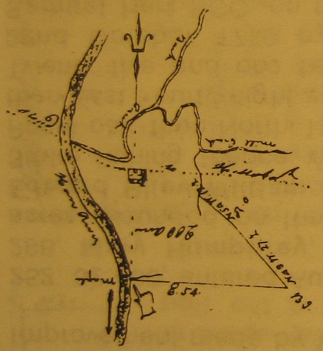
And in the accompanying legal description of the Galbreath grant, it clearly states that John Butler’s plantation was just south of there. However, the next state land grant to the south of Galbreath’s was a claim entered by John Armstrong, the man who built the first mill at what later became Swepsonville. Armstrong’s state land grant extended from Galbreath’s to a point well south of the Swepsonville mill site. At the same time, land grants still further south and east of Armstrong sometimes refer to “Butler’s Corner” or “Butler’s Line.” Drawing these land grants and piecing them together like a jigsaw puzzle, I can clearly see that both ends of the 1778 Armstrong grant are referred to by neighboring grants as Butler's. I am not sure why this was done this way, but John Armstrong apparently claimed that land in a sort of trust for his sister Ann Armstrong Butler, the wife of Gen. John Butler. Perhaps it related in some way to the fact that Gen. Butler was the State land grant agent for Orange County.
Unfortunately, Armstrong's land grants stop short of the Virginia Mills Powerhouse #2, and no other state land grants seem to show that site. CORRECTION: The land where my powerhouse stands was originally granted by the state to Samuel Hunter.
John Armstrong's Other Mill
As I said, John Armstrong owned and built the first mill in Swepsonville, prominently shown on the 1770 Collett map:
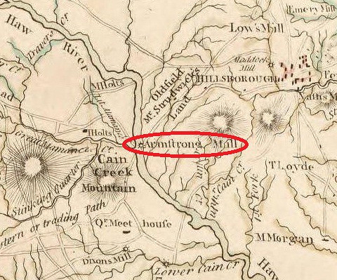
John sold the mill in Swepsonville to John Trousdale shortly before Armstrong's death at the end of 1790, but Trousdale only bought the mill itself on two acres. Apparently the remaining 638 acres more or less comprised Mount Pleasant and does not appear to have passed through John Armstrong's estate.
Armstrong also owned another mill on Haw Creek somewhat downstream of NC-54; he sold that mill to Joseph Hodge and Richard Christmas in April of 1790 (Orange DB 4, pg 692). Around 1840, that mill was purchased by Alexander Wilson who operated the school in Melville. By 1893 the site was known as Newlin's Mill as shown on William L. Spoon's marvelous map of Alamance County:
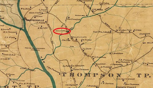
Here's a picture of the broken down Armstrong-Wilson-Newlin dam on a day when Haw Creek was high enough to paddle:
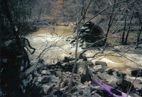
The Heirs of John Armstrong
The will of John Armstrong, dated Nov. 25, 1790, proved Feb. 1791, (Orange WB B, pg 121) mentions his daughters: 1) Elizabeth, 2) Mary, 3) Margaret, & 4) Rachel. Armstrong named his brother-in-law, Richard Christmas as one of the executors of this will. Briefly, regarding the daughters of John and Margaret Armstrong:
1) Elizabeth ‘Betsy’ Armstrong married a man named Stephen Glass in 1809. Glass owned, among other things, a mill on Back Creek. Elizabeth died in 1847. Sallie Walker Stockard’s History of Alamance says that Seymour Puryear owned “the Widow Glass’ property and that of Hunter and Wagstaff.” And we know that this same Seymour Puryear owned a gristmill, which he sold to Virginia Mills in 1881. But it is unclear how he came to own this mill or whether that property is the one that came from ‘the Widow Glass.’ CORRECTION: This land probably came from the Hunter family, not Mrs. Glass. This mill site, the Puryear Mill site, is where Virginia Mills Powerhouse #2 was built in 1905. I own that site now as the proprietor of Swepsonville Hydro, LLC:

2) Mary Armstrong (c. 1770- 11/4/1833) married Elisha Smartt in Orange Co., Mar. 7, 1792. Mary’s will, dated Nov. 1, 1833, (Mecklenberg Co. WB G, pg 147) gives her children’s names: Robert T. Cheek, John S. Cheek, Sarah B. Cheek and Rebecca Armstrong Marks. The last name Cheek is confusing, but apparently these were illegitimate children fathered by Silas or Cylas Cheek (see Meck. WB A, pg 196). In her will Mary Armstong Smartt refers to "sale of my land in Orange County."
3) Margaret Armstrong married John Sankston on Mar. 21, 1800, in Orange Co.
4) Rachel Armstrong apparently never married. Her will (OCWB E, pg 143; dated 13 Feb 1823; proved August Court 1827 left her estate to her niece Anne Glass, daughter of Stephen and Betsy [Armstrtong] Glass.
The Heirs of John Butler and Ann Armstrong
As I said, John Armstrong’s sister Ann married Gen. John Butler. Gen. Butler and Ann Armstrong had no children. Gen. Butler’s will was written May 20, 1785 (OCWB B, pg 1), and probably probated in January 1787. In the will he left everything to his “beloved wife.” That is, Ann Armstrong Butler.
After Gen. Butler’s death, Ann Armstrong married Maj. Richard Christmas, December 22, 1788, in Orange County, NC. There were no children by this marriage either. Ann died and left Maj. Christmas a widower. The will of Richard Christmas, dated June 25, 1830, proved May 1833, (OCWB E, pg 300) bequeathes slaves to Mary Armstrong Smart and Peggy Armstrong Sankston, "niece[s] of my deceased wife," but does not devise the Butler real estate. Gen. Butler’s nephew – a descendant of Regulator William Butler – sought to reclaim the Butler real estate that had been in the hands of Richard Christmas (as would have been Richard’s lifetime right in the lands inherited by his wife). Richard Christmas had apparently assumed that the lands would go to the Butler family and consequently did not devise them in his will. However, it appears that the Butlers ultimately failed and the land passed to the heirs of Richard Christmas.
The Heirs of Richard Christmas
So who were they? And what became of Mount Pleasant? I will post updates here when they trickle in. In the meantime, here are some other Swepsonville photos to enjoy.
The old Powerhouse #1 at Virginia Mills in Swepsonville, formerly the site of Armstrong's Mill, then Trousdale's Mill, then Murphey's Mill, then Ruffin's Mill, then Falls Neuse Manufacturing:
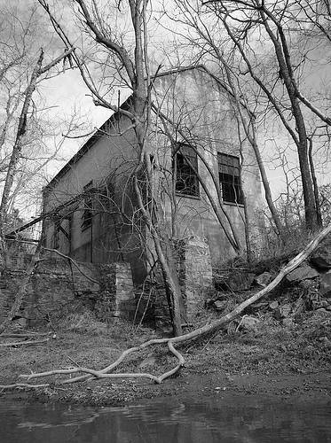
An aerial photo of the Swepsonville mill site:
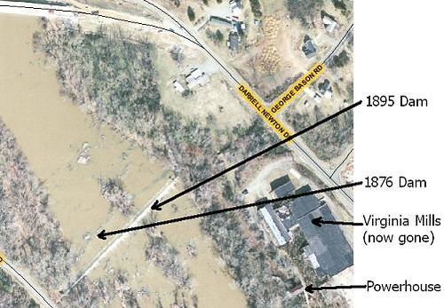
At first blush, it seems simple to locate Mount Pleasant, the home of Gen. John Butler. William Galbreath operated a ferry at the site of a traditional ford on the Haw River, about a mile above Swepsonville at the mouth of Back Creek. The 1778 State land grant to William Galbreath looks like this:
And in the accompanying legal description of the Galbreath grant, it clearly states that John Butler’s plantation was just south of there. However, the next state land grant to the south of Galbreath’s was a claim entered by John Armstrong, the man who built the first mill at what later became Swepsonville. Armstrong’s state land grant extended from Galbreath’s to a point well south of the Swepsonville mill site. At the same time, land grants still further south and east of Armstrong sometimes refer to “Butler’s Corner” or “Butler’s Line.” Drawing these land grants and piecing them together like a jigsaw puzzle, I can clearly see that both ends of the 1778 Armstrong grant are referred to by neighboring grants as Butler's. I am not sure why this was done this way, but John Armstrong apparently claimed that land in a sort of trust for his sister Ann Armstrong Butler, the wife of Gen. John Butler. Perhaps it related in some way to the fact that Gen. Butler was the State land grant agent for Orange County.
Unfortunately, Armstrong's land grants stop short of the Virginia Mills Powerhouse #2, and no other state land grants seem to show that site. CORRECTION: The land where my powerhouse stands was originally granted by the state to Samuel Hunter.
John Armstrong's Other Mill
As I said, John Armstrong owned and built the first mill in Swepsonville, prominently shown on the 1770 Collett map:
John sold the mill in Swepsonville to John Trousdale shortly before Armstrong's death at the end of 1790, but Trousdale only bought the mill itself on two acres. Apparently the remaining 638 acres more or less comprised Mount Pleasant and does not appear to have passed through John Armstrong's estate.
Armstrong also owned another mill on Haw Creek somewhat downstream of NC-54; he sold that mill to Joseph Hodge and Richard Christmas in April of 1790 (Orange DB 4, pg 692). Around 1840, that mill was purchased by Alexander Wilson who operated the school in Melville. By 1893 the site was known as Newlin's Mill as shown on William L. Spoon's marvelous map of Alamance County:
Here's a picture of the broken down Armstrong-Wilson-Newlin dam on a day when Haw Creek was high enough to paddle:
The Heirs of John Armstrong
The will of John Armstrong, dated Nov. 25, 1790, proved Feb. 1791, (Orange WB B, pg 121) mentions his daughters: 1) Elizabeth, 2) Mary, 3) Margaret, & 4) Rachel. Armstrong named his brother-in-law, Richard Christmas as one of the executors of this will. Briefly, regarding the daughters of John and Margaret Armstrong:
1) Elizabeth ‘Betsy’ Armstrong married a man named Stephen Glass in 1809. Glass owned, among other things, a mill on Back Creek. Elizabeth died in 1847. Sallie Walker Stockard’s History of Alamance says that Seymour Puryear owned “the Widow Glass’ property and that of Hunter and Wagstaff.” And we know that this same Seymour Puryear owned a gristmill, which he sold to Virginia Mills in 1881. But it is unclear how he came to own this mill or whether that property is the one that came from ‘the Widow Glass.’ CORRECTION: This land probably came from the Hunter family, not Mrs. Glass. This mill site, the Puryear Mill site, is where Virginia Mills Powerhouse #2 was built in 1905. I own that site now as the proprietor of Swepsonville Hydro, LLC:
2) Mary Armstrong (c. 1770- 11/4/1833) married Elisha Smartt in Orange Co., Mar. 7, 1792. Mary’s will, dated Nov. 1, 1833, (Mecklenberg Co. WB G, pg 147) gives her children’s names: Robert T. Cheek, John S. Cheek, Sarah B. Cheek and Rebecca Armstrong Marks. The last name Cheek is confusing, but apparently these were illegitimate children fathered by Silas or Cylas Cheek (see Meck. WB A, pg 196). In her will Mary Armstong Smartt refers to "sale of my land in Orange County."
3) Margaret Armstrong married John Sankston on Mar. 21, 1800, in Orange Co.
4) Rachel Armstrong apparently never married. Her will (OCWB E, pg 143; dated 13 Feb 1823; proved August Court 1827 left her estate to her niece Anne Glass, daughter of Stephen and Betsy [Armstrtong] Glass.
The Heirs of John Butler and Ann Armstrong
As I said, John Armstrong’s sister Ann married Gen. John Butler. Gen. Butler and Ann Armstrong had no children. Gen. Butler’s will was written May 20, 1785 (OCWB B, pg 1), and probably probated in January 1787. In the will he left everything to his “beloved wife.” That is, Ann Armstrong Butler.
After Gen. Butler’s death, Ann Armstrong married Maj. Richard Christmas, December 22, 1788, in Orange County, NC. There were no children by this marriage either. Ann died and left Maj. Christmas a widower. The will of Richard Christmas, dated June 25, 1830, proved May 1833, (OCWB E, pg 300) bequeathes slaves to Mary Armstrong Smart and Peggy Armstrong Sankston, "niece[s] of my deceased wife," but does not devise the Butler real estate. Gen. Butler’s nephew – a descendant of Regulator William Butler – sought to reclaim the Butler real estate that had been in the hands of Richard Christmas (as would have been Richard’s lifetime right in the lands inherited by his wife). Richard Christmas had apparently assumed that the lands would go to the Butler family and consequently did not devise them in his will. However, it appears that the Butlers ultimately failed and the land passed to the heirs of Richard Christmas.
The Heirs of Richard Christmas
So who were they? And what became of Mount Pleasant? I will post updates here when they trickle in. In the meantime, here are some other Swepsonville photos to enjoy.
The old Powerhouse #1 at Virginia Mills in Swepsonville, formerly the site of Armstrong's Mill, then Trousdale's Mill, then Murphey's Mill, then Ruffin's Mill, then Falls Neuse Manufacturing:
An aerial photo of the Swepsonville mill site:
Sunday, January 3, 2010
Chatham Coalfields, 1887
From the Carolina Watchman (1/20/1887):
"The Deep River coal field, Chatham county, North Carolina, has long been known to be of great value and of such importance as to make one wonder why it has never been worked and the coal placed on the market in competition with coal brought into the State. The Department of Agriculture had this field explored a short time ago by a competent man, and most probably as a result of that work, the district is now receiving the attention of some moneyed men from the State of Penn. The field has advantages which cannot be despised, especially in its location with reference to districts with which it must compete. It is convenient to all eastern Carolina, and within easy reach of the Atlantic Ocean at Morehead and Wilmington and at Charleston, S.C.; supplying the markets of the Carolinas, it has advantages voer both Virginia and Tennessee, and these advantages are so apparent that further reference is unnecessary, though figures could be given if required, to prove this position.
"The cost of mining is placed by the expert at $1.50 per ton, which is rather more expensive than such mining generally costs but is accounted for by the fact the work must be done 'below water level and on a moderately steep dip the coal must be hoisted, the water raised,' &c. But even this disadvantage does not eat up the caclulated profit, which is estimated to be ample when advantage of location is considered; for instance at Weldon the margin would be 70 cents to $1; Raleigh $1,50 to $1.80; Greensboro $1.47 to $1.77; Salisbury 75cts to $1.; Charlotte and Columbia, S. C. 80 cents to $1.07; fayetteville, (N.C.) $2.24 to $2.54.
"'These figures are large enough to show that a very considerable reduction could be made in the price of coal and yet leave ample profit for the operators.' As to the area, it is estimated at 2,160 acres. This may be reduced to say nearly one hald, as no allowance were made for trapdykes or thin spots in the area. This area is calculated to yield 6,000 tones to the acre, but a safer estimate would be 5,00 tons to the acre. This would make the available tonage more than six millions.
"TO BE WORKED
"At Egypt in Chatham county, a Pennsylvania Co. has purchased a large area of this field and propose to begin operations there in the near future. They propose to begin by supplying local demands along the lines of road most convenient to them, and to gradually broaden the business.
"There are also parties contracting for the Ore Hill iron property near, for the purpose of erecting furnace. [sic] The indications for that particular district are brightening. When work is once begun there in earnest a large and permanent business will result."
A View of the Chatham Coalfields, 1861
From the Carolina Watchman (Salisbury) 8/5/1861:
"DEEP RIVER COAL - As the coal of the Deep River region is now about to be brought into, it may not be inappropriate to make some explanations concerning it, and the operations being carried on there. All bituminous coal contains more or less sulphur, and this sulphur increases in quantity the nearer you approach the out-crop; hence the best and purest coal is obtained from deep shaft workings. There is but one shaft as yet in the Deep River region 0 it is at Egypt, and persons purchasing coal should be particular in inquiring if it came from Egypt, if they wish to obtain the best quality mined so far.
"So many exaggerated statements have gone forth as to making of oil and iron in that region, that I took the trouble to examine into what had been done, and to observe what is likely to be done. At the Farmville place, a great mass of machinery, &c., has been put up, but so far as the making of oil, it was a failure - only one barrel having been made in a week. This result was the fault of the works and their management, not of the black band iron ore. A good quality of oil can be made and profit accure [sic] to the operator, if a different style of works were put up, and it is now worth the attention of our people.
"At the Tysor place, where I had seen announced in the paper that vast quantities of iron had been made, I found several changes from the original plan of the works - changes which have resulted in nothing but loss; but as now they have returned to the original old plan of a Catalan forge, something may be done when the works are completed.
"At Ore Hill, ten miles North of Deep River, a furnace is being put up, and will be at work in about two weeks. The ore at this place is very superior, and was used during the revolution.
"At Egypt, a very superior quality of coal is being taking [sic] out, and one hundred tons a day can easily be taken out. The only drawback is the unfinished state of road.
"I make these statements because I learn a quantity of out-crop coal has gone to market, and given some dissatisfaction, and that the plain, simple truth as to what is doing on Deep River may be known.
"Fayetteville Observer."
Subscribe to:
Posts (Atom)

