Thursday, December 23, 2010

The Hermitage

The two of Alamance County's most prominent historical figures lived just opposite Swepsonville near the confluence of Big Alamance Creek and the Haw River. Archibald D. Murphey was the founder of lower public education, a great proponent of internal improvements (canals, plank roads etc.), a lawyer, a judge and a state senator.

115-b-MurpheyArchibald_FP02-M978-A673d_web
Judge and Sen. Archibald Debow Murphey

Murphey nearly went bankrupt in the banking crisis of 1819 and was forced to surrender his extensive real estate holdings to his friend and creditor Thomas Ruffin. Ruffin became an even more eminent (and later infamous) figure serving on the NC Supreme Court and authoring the Court's opinion in State vs. Mann.
200px-Thomas_Ruffin
NC Chief Justice Thomas Ruffin

The homeplace of Murphey and later Ruffin was called the Hermitage. According to the Papers of Archibald Debow Murphey (pp334-335), the Hermitage stood "three miles south of the site of Graham and about half a mile from the stage road leading from Hillsboro via the Hawfields to Salisbury." Murphey (and later Ruffin owned) the waterpower site which later became Virginia Mills in Swepsonville. "The mills were about two miles to the east [of the Hermitage], at the confluence of Haw River and Great Alamance."

The site of the Hermitage is shown on W L Spoon's 1893 Map of Alamance County:

The Hermitage

The Papers of A D Murpehy described the site: "A lane ran southward from the public road to the front gate, where it turned to the right and ran along the northern border of the yard and into an enclosure containing the kitchen, servants' quarters stables, and other outbuildings. On the eastern side of the dwelling-house, about thirty feet from it, stood Murphey's law office, and under the office was a wine cellar. Further east was an orchard. In the rear of the house was a garden, which adjoined a lot lying on Great Alamance Creek."

"The house was a plain, substantial wooden building having two stories in the central portion and one and a half in the winds on the eastern and western sides. At the right end of a large hall as one entered was a room called Judge Ruffin's room after he took up his abode there, and at the left a library and parlor. These rooms formed the first stories of the wings. At the back of the hall were the dining-room and a guest chamber, and behind these a narrow hall, with a pantry and storeroom at its ends, and a piazza overlooking the garden and creek. Upstairs, in the central portion of the house was another large hall, and in the rear two bedrooms, a storeroom, and a back hall. Two spacious guest chamber, with four dormer windows in each, formed the second floors of the wings."

As authority for such a detailed description of the house, the editor of Murphey's papers tells us: "For this description I am indebted to Col Bennehan Cameron, of Stagville, who often visited the Hermitage during his boyhood."

Friday, December 10, 2010

A Tolerable Bateau Navigation

Here's an excerpt from my next forthcoming book A Tolerable Bateau Navigation: The Story of the Deep and Haw River Navigation Company, 1796-1881. You can order the book via email: Mark_Chilton@hotmail.com


Round IV on the Upper Cape Fear: A Bateau Navigation 1828-1832


By the fall of 1828, the Fayetteville Observer was already complaining again about the Cape Fear Navigation Company’s emphasis on the Upper Cape Fear: “We understand that the hands employed upon our River are at work 20 or 30 miles above this town; to which no one could have a reasonable objection, if the Navigation Company had really removed the obstructions between this place and Wilmington, and had the funds left to prosecute the works above . . . The Navigation Company may possibly be promoting their own interests by their operations; but the merchants and boat owners here complain, and apparently with reason, that they pay heavy tolls, for no good that they can see except to furnish money to prosecute a visionary scheme of opening a navigation to Haywood, or Murphey’s Mills [Swepsonville]. Is there no remedy?” In response, the Board of Internal Improvements’ engineer Alanson Nash supervised the removal of snags below Fayetteville and the construction of an additional wing dam at Spring Hill Shoal (Observer 10/30/1828). Nash also reported that more such improvements were needed at the ferry at Elizabethtown and at the old ferry site a few miles below (1828 Report).


The summer of 1829 was a time of great optimism for the Cape Fear Navigation Co. The renewed investment from the State of North Carolina was making it possible to make major progress on improving the river above Fayetteville and the passable condition of the lower Cape Fear was allowing the Company to collect significant tolls. As the Recorder reported (6/10/1829) the CFN Company’s Directors at their annual meeting found “the affairs of the Company in a much more prosperous situation than at any other meeting during the time they have had the honor to direct its concerns.”


In fact, the papers were full of promising reports about navigation of the upper Cape Fear in the summer and fall of 1829. By July, the Recorder said that work on the Buckhorn locks was complete and that hands had been moved down to Smiley’s Falls (7/20/1829), allowing Haywood businessman Jonathan Haralson to send his boat the Clara Fisher to Fayetteville with 27 bales of cotton using hired boat hands (see also Observer 5/28/1829). Work was still progressing at Smiley’s Falls in September, but Archibald D. Murphey was able to send his boat from Haywood to Fayetteville (Recorder 9/23/1829). And still another trip through Smiley’s Falls reportedly at low water and at night was approvingly noted in October that year (Observer 10/22/1829).


The newspaper accounts certainly make it appear that the navigation of the Upper Cape Fear was complete by the end of 1829. As the Recorder (9/23/1829) put it: “The river, for the first time this season, is in good working order and nothing is wanting but hands for which liberal wages are offered.” But high-water in the winter of 1829-30 must have been hard on the works put in place in 1828 and 1829, as the summer of 1830 saw a furious new round of improvements under way above Fayetteville.


In 1830, the BII’s superintendent on the river, Abraham G. Keen built a breakwater dam at Haralson's landing, blasted ledges and built wing dams at Upper Little river falls, built more wing dams at Williams' Falls, and removed fish traps at Borough Shoals. They did more blasting and built more wing dams at Stewart's Creek ledge, at Shaw's Upper Falls and Wirt's Fish Stand Falls, at Thorington Creek Shoals , and at Jones Falls and Massie's Fish Stand Falls - to say nothing of wing dams built at M'Craney's Fish Stand Falls, Dry Creek Shoals, Norrington's Falls, Ford Shoals, Mrs. Atkins Ferry Shoal, John Atkin's Fish Trap Shoals, M'Neal Shoals, Guess Ford Shoals, James Battle's Falls, Blalock's Falls, and Brazier Falls. And they also built "several other dams." To his credit, Mr. Keen complained only that "[o]wing to the extreme low water this summer, I had a great deal of unnecessary work to do to enable us to get up the river with our loaded boats." (1830 Report)


The sweaty and noisy summer of 1830 must have resulted in a notable level of success. The BII met in June of 1830 at Haywood (Observer 6/10/1830) and “proceeded down the River in one of the Company’s boats, accompanied by several of the neighboring planters, and there being no obstruction in the River for ten miles, they had a pleasant passage to the dam across it near the Buckhorn Falls . . . The Boat then entered an outlet from the river which leads to the Buckhorn Canal. The river being low, Mr. Keene had some fears that it would not be found sufficient to carry the boat through the Locks; but the event found his fears groundless . . . and when [the boat] again entered the river, it met with but few obstructions. It had indeed to pass a number of inconsiderable falls, and some very shoal places; but from the sluices cut through the former, and the activity of the hands in managing over the latter, but little inconvenience was sustained from either.” The report allowed that the passage through Smiley’s Falls was rapid, but successful owing to wing dams, sluices and blasting that had been going on. Along the side of these long Sluices are erected substantial Stone Walls, which serve for towing paths for ascending boats.” (See also Observer 7/15/1830)


In fact, the level of optimism about the improvements to the upper Cape Fear was so high that some quarters seemed to think that boats, rather than wing dams were the missing ingredient. “As soon as it shall be generally known that there is a good navigation opened between Haywood and Fayetteville,” the Observer opined, “there is no doubt that the planters within a reasonable distance from the River, will avail themselves of this easy mode of sending their crops to market.” (Observer 6/10/1830) Even George M'Neill, no admirer of the Board of Internal Improvements, grudgingly admitted: "[T]he River was sluiced through Smiley's falls, and other falls between Fayetteville and Averasborough, which afforded a tolerable navigation for such bateaus as could pass the Canal and Locks at Buckhorn falls." (1838 Report)


The Backlash


In late 1830 increasing frustration with the Navigation Company led to sharp criticism in the newspapers. An anonymous letter to the editor of the Observer of 11/25/1830 bemoaned the navigation problems below Fayetteville and asked: “Why have not the stockholders for the last 3 years foreseen these fatal consequences at their general meetings? The only answer that can be given to that question is that the well known zeal manifested by Mr. [CFN Co. President James] Mebane in promoting operations above Fayetteville, and his representation of the 650 shares of stock owned by the State (and which generally constitutes a majority of stock represented at those meetings) precludes the possibility of any successful argument in favor of the true interests of the Company.” Still more criticism was published 12/2/1830 and on 12/23/1830. The Observer reported that a group of Wilmington residents had organized a petition to the legislature to revoke the CFN’s power to charge tolls on the river because of the shortcomings of the Company’s efforts between Fayetteville and Wilmington.

This critical sentiment was also reflected in the CFN Company’s annual report to the BII in 1830. "When the work now in progress, under the direction of your Board, between Fayetteville and Haywood is completed, it is hoped that the large sum expended at and about Buckhorn Falls will not be entirely unproductive. The Canal at and near Fayetteville is not likely to yield the company any income; but, on the contrary, it is a continual expense." (emphasis in original).


In 1831, there was evidently renewed unhappiness with the company in the legislature, as the Board of Internal Improvements was directed to assess the question of what had been accomplished by the Company . . .


For the rest of the story, please order a copy of the book via email: Mark_Chilton@hotmail.com

Sunday, December 5, 2010

McCulloh's Petition to the King

I transcripted this from a hand written collection of Henry McCulloh's writings contained in the Manuscripts collection of Duke University:

General Observations in Relation to the Steps which were taken previous to the Earl of Granville’s division of the Two Carolina’s with the Crown

Lord Granville by His Petitions to His Majeesty humbly Prayed His Majesty that his one eighth part of the Soail of the Two Carolina’s might be set out and alotted to him in such part of the said Provinces asshould be Agreed on between such Persons a His Majesty should be pleased to appoint and such Persons as the said Lord Granville should name on his part.

His Majesty was pleased to referr the said Petition to the Right Homble the Lords of the Committee of Council and their Lordships referred the same to the Right Honble the Commissioners of Trade and Plantation for them to Consider thereof and Report their Opinion thereupon.

And in pursuance thereof their Lordships did Report That they conceived the method proposed by the said Lord Granville would be the most Effectual.

Which said Report the Lords off the Committee of His Majesies most Honble Privy Council did agree to and on the Twenty Fourth of August 1742 made their Report thereupn to His Majexty and gave it as their Opinion that the said Lord Granville’s Property should be Separated from that of His Majesty, and humbly proposed that proper Persons should be appointed as Commissioners on His Majesties behalf not exceeding Five who in Conjunction with the like Number of Persons to be appointed by the said Lord Granville, should be Impowered to Sett out and Alott to the said Lord Granville One full Eighth part of the said Provinces of Carolina in such part of parts of the siad Provinces as should be Agreed upon by the said Commissioners. And that they should be required to make a Return of their Proceedings to His Majexty in council within Eighteen Months from the dates of His Majesties Order. And alsoto lay before His Majesty A Plan containing a full and exact Description of the said Land together with the respective Boundaries thereof.

And for the better Guidance of the said Commissioners that it might be Advisable for His Majexty to require the said Commissioners to follow and Observe such Direstions and Instructions as might be given from time to time either by His Majesty or by those who act under His Majesties Royal Authority.

Which Report His Majesty was pleased to Approve of as may more fully and at large Appear by His Majesties Order of Council dated Fifteenth day of September 1742.
And in pursuance thereof His Majesty by His Royal Instructions thereupon given the Tenty fifith day of April 1743. Required and Commanded the Commissioners to make a Return of the whole of their Proceedings within Eighteen Months from the date of the said Order, and also required them to transmit a full and Exact description of the Lands so to be set out and Alotted to the said Lord Granville with the respective Boundaries thereof. And that the said Commissioners should follow such Instructions as might be found necessary to be given to them either by His Majesty or by those who act under His Majexties Royal Authority.

His Grace the Duke of Newcastle (as Conceived at Mr Belaquier’s Request) wrote a Letter to the Governor of North Carolina dated the Ninth of June 1743, including a Plan drawn in London of such part of North Carolina as was deemed to be an Eighth part of the whole of the said Province but His Grace did not direct that the Commissioners should follow the said plan and only sent it as what might be of Service to His Majesty’s Commissioners in making the said Division.
Mr. Belaquie by his Letter dated eleventh June 1743 to Col. Edward Moseley who was Lord Granville’s Agent inclosed to him a Map or Plan of said tract drawn by Mr. Warner in London with directions hiw to proceed in that matter for Ld. Granville’s Service.

And Mr. Belaquier in his Letter to me dated Eleventh June 1743 wished that his Lordship had Signed a Commission at Hanover Appointing Commissioner sin his behald, and had given the necessary Instructions to Mr. Moseley which were to be Communicated to me. That he had Transmitted to mr Moseley a Copy of the Duke of Newcastles’s Letter to the Governour dated the Ninth of June 1743 Including a Map or Draught of such a Tract of North Carolina adjoining to Virginia as is deemed to be an Eighth part of the whole, together with some ____ amd directions upon the same as what may possibly be of use to His Majesties Commissioners. And Mr. Balaquier further said that he had in Command from his Lordship to Assure Mr. McCulloh that His Lordship would be Obliged to him for his Complyance with the several Matters above mentioned.

I pray leave to Observe that as Lord Granville was then Secretary of State and that His Majexty had Commanded the Commissioners to Observe such Instructions as were given to them by those who Acted under His Majesties Royal Authority I did not Conceive myself to be at Liberty to Oppose Mr. Moseleye in any Matter which related to His Lordship.

The Commissioners in behalf of the Crown and those Appointed by Lord Granville met together in October 1743. And on looking into His Majesties Orders of Council and the other Letters and Papers transmitted to them Did not Apprehend themselves to be at Liberty to do any thing further than to lay out the Latitude, and then to run a West Line, and accordingly went upon that Duty without taking the Oaths usually required in such cases to do Justice to each of the Parties.

The Season of the Year being then far Advanced and the Commiss.ers being required to make a return within Eighteen Months from the date of His Majesties Order in Council, they did not run the West Line further than to a place called Pamticoe River.

The Return made to His Majesty by the Commissioners is dated the Sixth of December 1743 Setting forth that in pursuance of His Majesties Royal Order in Council dated Fifteenth September 1742 and Instructions dated 25th April 1743 they did set out and Alott to Lord Granville One full Eighth part of the Provinces of North Carolina next Adjoining to Virginia on the East by the great Western Ocean. And as for southwardly as a Cedar Stake set on the Sea side in the Latitude Twenty five Degrees and Thirty four Minutes North Latitude being Six Miles and an half to the southward of Chickinacomack Inlet from that Stake by a West Line which passed Tenty five Foot to the Southward of the House where Thomas Willis lived to the West as far as the Bounds limited by the Charter granted to the Late Lords Proprietors. Which West Line was run One Thousand Six hundred and sixty Poles to the North of the South end of Bath Town.

All which was most humbly Submitted &c &c &c.

At the time of making that Return a Plan was also Transmitted which had been Separated and set out for Lord Granville with a Scale of Miles Annexed thereto.

It is proper to Observe here that the Commissioners did not say that the Plan so Transmitted was a full and Exact description of the Return made by them nor in Truth was it, there being a Supposed Line given in the following words which were not contained in the Plan, namely So West as far as the bounds of the Charter granted to the late Lords Proprietors.

The Return was drawn up by Lord Granville’s own Agent, and so gave roo for the deception whicafterwards Appeared in the Prosecution of the said Affair.

By His Majesties Orders the Plan and Return were to Agree, as by the Plan would Apear what Extent of Country was Alotted to His Lordship. But the Commissioners having acted only by a Suppsed Plan sent to them they had not time to run the Boundary Line, not to perfect their Plan and Consequently sent in Open.

However this being about the time when Lord Granville resigned his Commission as Secretary of State, he was willing to have the matter determined. And the Affair was Represented to the Lords of the Committee of Council as to Cause in them an Opinion that the Return and Plan were one and the same as will more fully appear by the following Report.

The Right Honourable the Lords of the Committee of Council on taking the said Returna nd Plan into Consideration the Nonth day of May 1744 were pleased to Report to His Majesty that the Commissioners having transmitted to His Majesty a Plan containing a full and Exact description of the said One Eighth part of the said Provinces or Territories so set out and alotted to the said Lord Granville Their Lordships were humbly of Opinion that His Majexty might be pleased to Approve of the said Return and Plan and the Alottment thereby made to the said Lord Granville. And that thererupon it might be advisable for His Majesty to Order his Attorney and Solicitor General to prepare the necessary Instruments or Deeds Conformable to what was ---- Contained in the aforesaid Reports.

It is to be Remarked that when the Return and the Plan were copied out in Order to be laid before His Majesties Attorney General, the following words were added to the Copy of the Return, Viz: “And the said Commissioners did pursuant to His Majesties Order in Council Transmit to His Majesty a Plan containing a Full and Exact Description of the said One Eighth part of the said Provinces or Territories so set out and Alotted to the said Lord Granville.”
It is very probable that if the above words had not been so added to or inserted in the Copy of the Return made by the Commissioners that His Majesties Attorney General would have perceived the great difference which really was between the Return and the Plan, so that the necessary Instruments and Deeds could not have been made out agreeable to what is contained in the aforementioned Reports.

The deeds as drawn by the Attorney General are worded with Extreme Caution and Convey to Lord Granville only such Eighth part of the said Provinces or Territories as are Separated set out and Alotted to Lord Granville.

Which words (as concieved) are really Conjunctive and so Lord Granville Cannot avail himself of any more Lands under the said Grant than what are Comprized within the Plan returned by the Commissioners Especially for that the said Plan and Report Annexed thereto as laid before the Attorney General are said to Conaitna a full and Exact description of the said One fulll Eighth part of the said Provinces or Territories so set out and Alotted to the said Lord Granville.
But Lord Granville being of Opinion that the supposed Line above mentioned might still be Carried into Execution and a New Line run out.

Mr. Moseley his Lordships Agent prevailed on the Governour to Appoint the same Commissioners who were formerly authorized by His Majesty (although their Commission was then Expired near Two Years) to meet such Commissioners as Lord Granville then Appointed. And they accordingly met the latter End of March 1746 and run a further Line for Lord Granville from Pamticoe River to the Westward of Nues River. And they having met again in September 1746 run a further Line from Nues River to the Westward of Peedee River including the whole of the said ___ survey about One hundred and forty Miles in length, and if the supposed Line should ___ be carried on, it will Extend at least Two hundred and fifty Miles further.
In running the said Lines the Commissioners did not make any Allowance for the difference which induced me at my own Expence to Employ one of His Majesties Deputy Surveyors to Measure the Distance between Lord Granville’s Line on Pedee River to the Virginia Line, and on Surveying of the same it was found that Lord Granville had Thirteen Miles and hald in Breadth more than he was Intitled to, even Admitting that the Commissioners had a Power to proceed further on the said supposed Line.

If Lord Granville should be Allowed to keep possession of all he Claims under the Supposed Line, One Fifth part and more of the Provinces of South and Norht Carolina will come within His Lordship’s Division, Whereby One Fourth part and more of the White Inhabitants of the said Colonies will be Included therein.

But if Lord Granville should be restrained or Limitted to what is Comprized in the first Survey and Plan returned thereon His Lordship will not possess above one Twelfth part of the Lands, Althoguh in Value and point of Settlement it is more than equal to an Eighth part of the whole Provinces.

My Motive in troubling your Royal Highness with the above Representation is to Evince the Truth of my former Remarks and shew that when the Rules of Office are dispensed with, not only the Crown but the Lords of the Privy Council are Subject to Surprize.

Saturday, October 9, 2010

The Fort of Deep River at Coxe's Mill

I have to return one last time to the subject of David Fanning's headquarters at one of the two Cox's Mills near the Deep River in Randolph County, NC. You may recall that Harmon Cox has a mill on the east side of the Deep on a tributary called Millstone Creek, while William Cox had another nearby on Mill Creek on the west side of the Deep River.

In his memoirs, Fanning repeatedly refers to his headquarters as being at “Coxe’s Mill” and “on Deep River.” At one point he says that he had 140 men at the site and refers to it as “the Fort of Deep River, at Coxe’s Mill.” But Fanning never makes it clear which side of the river he was on and therefore it is unclear which Cox's Mill.

I wrote about this before and concluded that it seemed more likely that Fanning's HQ was at William Cox's Mill on the west side of the Deep. Earlier this year, this whole issue was much further examined by Warren Dixon of Randolph County, leading to the State changing the historical marker!

http://www.ncmarkers.com/Markers.aspx?ct=ddl&sp=search&k=Markers&sv=K-10%20-%20COX'S%20MILL

Warren concluded that Fanning's HQ was more likely on the east side at the Harmon Cox Mill.

Thinking about all this the other day, I remembered that Fanning wrote in his memoirs: “the two rebel parties had joined, being about 400 in number and encamped at Brown’s Plantation, about 2 miles up the river and on the opposite side.” I have looked before for old Orange County deeds that might correspond to "Brown's Plantation" but come up empty handed. Warren Dixon tells me that he and Mac Whately likewise attempted to find evidence of Brown's Plantation, but also found no firm information.

Well, yesterday it occurred to me that Fanning was speaking of the time of the Revolution and that Brown's Plantation might have been a grant from Earl Granville, so I looked through the Granville grants. Lo and behold:

Granville Grant 383 1 August 1760 Daniel Brown, planter, ten shillings the south side of Deep River, begin at William Coxe's corner spanish oak . . .up the river to the beginning . . . surveyed 13 Oct 1759.

This could easily be Brown's Plantation. The fact that William Cox is his southern neighbor shows that this grant is in the right vicinity. If that is indeed Brown's Plantation, then that would place Fanning's HQ on the north/east side of the Deep River at Harmon Cox's Mill - consistent with Warren Dixon's conclusions.

Thursday, September 16, 2010

A Brief History of Smith Level Road

Long before the Town of Carrboro and even before UNC, there was a road that connected Hillsborough to the town at the limits of navigation on the Cape Fear River – the nearest inland port – then called Cross Creek but now called Fayetteville. That road ran high up in the watershed of New Hope, Bolin and Morgan Creeks, just a mile west of the New Hope Chapel for which Chapel Hill is named. That road is Old NC 86/Old Fayetteville Road/Ray Road/Smith Level Road.

Though the old Fayetteville road is not named on John Daniel’s 1792 survey of the proeprties donated to start UNC, the road is nevertheless plainly shown:

Daniel Map 1792 Smith Level

The part of the road where it crossed Morgan Creek is now gone, but there used to be a bridge there. The last remains of that bridge are still there, a single steel rail still spanning the creek. The bridge was nearly directly at the McCauley Mill on Morgan Creek. The University Lake Dam stands on the same site that the McCauley Mill dam did.

When George W. Tate produced the first detailed map of Orange County in 1891 he showed largely the same road configuration:

Smith level

However the McCauley bridge site was abandoned in the 1920’s (probably about the same time the mill was abandoned) in favor of another old bridge location a little further down stream (where the present bridge is). South Greensboro Street was not extended down the hill to that location until the 1950’s sometime, but Old Pittsboro Road in Carrboro wended its way down to meet Merritt Mill Road and cross Morgan Creek. The present bridge location had been long in use and is also shown on the 1792 Daniel plat. Before the University was built an alignment more or less equivalent to Cameron Avenue/Merritt Mill Road/Smith Level Road lead from the old Fayetteville road up to the New Hope Chapel (which formerly stood where the Carolina Inn is today).

Probably since the 19th century, this road has been called Smith Level Road after the Smith family farm which was along it. The Smith house is that stately home on the west side of Smith Level Road, about 2/3 of the way to Chatham County from Carrboro. It was once the home of Sidney Smith a white slave owner whose African American descendants include Pauli Murray. The road is called Smith Level because of the flat topography particularly on the southern half of the road.

In fact the unusually flat topography is the very reason the old Fayetteville road ran that way. Considering the inherent advantages of the route and the fact that Hillsborough was the site of a Native American village from pre-Columbian times, it is conceivable that the route from Hillsborough down Old NC 86/Old Fayetteville Road/Ray Road/Smith Level Road may well have been a Native American trade route from long ago.

Friday, July 30, 2010

The Trading Path through the Hawfields

NOTE: I am indebted to David Southern for alerting me to many of the sources cited herein.

The well established Native American path across the southeast Piedmont was commonly called the Indian Trading Path, the Catawba Path, the Old Trading Path, or the Western Trading Road. In its full extent, the Trading Path ran from the vicinity of Petersburg, VA to Mobile, AL. More locally, the Trading Path had a well defined route from the Eno River to the Haw River. From the Eno it more or less followed the current path of Old NC 10, Bowden Road, and Old Hillsborough Road to the present site of the Hawfields Presbyterian Church on NC Hwy 119.

1115091413

From there, the Trading Path divided briefly. One route following Hwy 119 south into what is now Swepsonville and fording the Haw River just below the present day ruins of the mill dam. The other route followed an alignment formed by Kimrey Road, North Jim Minor Road, and the private driveway now named Old Reatkin Lane, crossing the Haw at the place known as Galbreath Ford/Ferry/Bridge about ½ mile below NC Hwy 54.

Some have said that there was not one Trading Path, but that there were many Trading Paths, being a series of braided footpaths that led between and among several different fording sites on each major river that the Trading Path crossed. The Many-Trading-Paths theory is propounded in opposition to the view that there was only one true Old Trading Path. It appears that there is truth in both points of view. In the 18th century, there was really just one route that was widely known as the Old Trading Path between the Eno and Haw Rivers, except for the final leg where the path divided on its way to two (or perhaps three) different fords. When old land and court records of Orange County refer to the Trading Path or Trading Road, they mean this particular route.

From the Eno River

From the west bank of the Eno River, the Trading Path crossed the Granville land grant to Henry Lemmon (Gv 25) though neither the text of the grant nor the accompanying survey shows the Trading Path. Next the route crossed the land grant to James Rayley (Gv 142), the survey showing the route as an un-named dotted line:

1

Then the Trading Path crossed right between the Granville grants to James Dickie (Gv204) and James McGowan (Gv 643) probably forming the border between them, though neither the grants nor surveys mention it. The Court of Pleas and Quarter Sessions minutes for June 1755 note: "James Dickey and Robert Witty from hence forward, do work on the Trading path Road, & under the Inspection of Major Mebane."

Next the path crossed German Baxter’s state land grant (NC 272), where it is depicted in detail without being named:

German Baxter

Part of Baxter’s land was conveyed to Mehitabel Coit in 1789 (ODB4, pg 201) “on the side of the Great Road formerly called the Old Trading Path.”

2

From there, the Trading Path entered land granted by Granville to William Churton (in Misc Gv Papers; Survey 15 Aug 1760). The Trading Path is shown plainly and labeled “Trading Path” on the survey:

Wm Churton on the Pollock Line

Next the Trading Path entered a 5,000 acre tract which had been granted to George Pollock in 1728. William Churton’s 1754 plat of the Pollock Tract distinctly shows a road crossing the southern end of the tract following almost precisely the present alignment of Old NC 10 and Bowden Road. The Trading Path is so faint on the Pollock Plat, that I added a black line that runs parallel to the route just north of it:

Pollock Plat

Descendants of George Pollock granted several parcels near or on the Trading Path in the 1840’s: To Wesley Miles along “the Old Great Road,” to Charles C. Smith “on the north side of the Old great Road,” and to Wilson Brown on “the Old Great Road” (ODB 29, pg 447). Although none of those deeds happen to refer to it as the Trading Path, other land records of that location do. During the Revolution, as Hawfields settlers filed State land entries left and right, local surveyor James Smith obtained state land grants for two parcels that were within the Pollock Tract. His state grant NC 30 amounts to the west half of Pollock’s lot #2. And NC 179 is part of Pollock’s lots #1 and #2 – both immediately along the current route of Old NC Hwy 10 and Bowden Road. These grants to James Smith were no doubt invalidated, but notably both of these grants refer to being “on the old Trading Road.”

3

Crossing Moseley Tract 1

Leaving the Pollock Tract, the Trading Path entered a 10,000 acre tract which had been granted to William Moseley in 1728. Moseley’s grant explicitly mentions “where the Indian Trading Path crosses” Haw Creek (PB 2, pg 222). This land later passed into the hands of Samuel Strudwick. Strudwick parted out Moseley’s tracts, selling to various settlers who had occupied this area starting in the latter 1740’s. Along the Trading Path, Strudwick sold 718 acres to Alexander Mebane in 1769 (ODB 2/550) – land that Mebane had occupied 20+ years. While the deed to Mebane makes no mention of the Trading Path, the minutes of the Orange County Court of Pleas and Quarter Sessions for December 1752 authorized Mebane to build a grist mill “near the trading path.” That mill was more recently known as Gill’s Mill on Haw Creek, just below Bowden/Hillsborough Road. Court of Pleas Minutes for June 1759 mention that Alexander Mebane's house is on the "trading path road." Minutes for September 1759 refer to "the Western Path where Alex Mebane Esq lives." Thus showing that the Western Path and the Trading Path were interchangeable terms for the same road.

slide 4

Other parts of Moseley Tract 1 were claimed by John McAdams (NC 534) and Samuel McAdams (NC 196) under state land grants (in direct conflict with Strudwick’s ownership). Neither of the McAdams grants mentions or shows the Trading Path.

4

Crossing the Lovick Tract

The Trading Path then crossed into the 1728 land grant of John Lovick. The original grant to Lovick also twice explicitly mentions “where the Indian Trading Path” crosses various creeks (NC Patent Book 2, pg 223). The Lovick Tract was more or less forfeited during the Revolution because of the owner’s British allegiances, but various state land grant claims across the Lovick Tract show a series of properties with the Trading Path crossing them:

Rowland Hughes’s land grant survey (NC 48) definitely shows the Trading Path, although it is unnamed. John Sloss’s land grant (NC 40) had roads on two sides, one the “old Trading Road” and the other “the Great Road.”

John Sloss

Interestingly, the legal description calls the more northerly of the two road alignments “the old Trading Road” referring to essentially modern Kimrey Road, leading to the Galbreath Ford site about ½ mile downstream of the modern NC Hwy 54 bridge. See The Galbreath Ford below.

The adjacent land grant north of John Sloss’s was William Rainey’s (NC 182), which also refers to this road as “the old Trading Road.”

William Rainey

On the strength of this alone, the evidence would seem to indicate that the Galbreath Ford was the sole route of the Trading Path, but as we will see, the Granville Grant to Campbell and the 1728 grant to Lovick show that the Trading Path ford was also at Swepsonville.

5

Thomas Lockart’s land grant (NC 67) does not show or mention the Trading Path, but the next survey to the southwest, George Allen’s (NC 162) clearly shows an unnamed road. Likewise James Fruit’s land grant (NC 220) shows the Trading Path crossing the south end of his grant, as well as part of the road to Galbreath Ford which crossed his grant further north; neither road is mentioned by name:

[George Allen Pic]

Following Hwy 119, the Trading Path formed the boundary between James Kennedy (NC 417) and Joseph Sloss (NC 62), both surveys plainly showing “the Great Road.” Next the Trading Path crossed the land grant of Moses Crawford (NC 91) but it was neither shown nor mentioned.

6

Jane Russell’s survey (NC 154) clearly shows the road forking (both forks called “the Great Road”):

Jane Russell (2)

The western fork led to the ford in Swepsonville. The southerly fork led across James Trousdale's land grant (NC 1, showing the road) to the third in the trilogy of fords in the Swepsonville area, the Island Ford. See The Island Ford below. Leaving Jane Russell’s along the western fork, the Trading Path entered the land grant of John Armstrong (NC 364). Though not shown on Armstrong’s plat, the Trading Path crossed through the middle of Armstrong’s land reaching the banks of the Haw River in what is now Swepsonville.

Butler’s Ford

The Trading Path proper crossed the Haw River just below the Swepsonville mill site. This ford is shown on Granville’s 1761 land grant to John Campbell (Gv 531) on the west side of the Haw. This land had originally been surveyed for Adam Davies and the Davies survey explicitly shows the “Western Trading Path.” The legal description refers to Campbell’s grant as being “on the Trading Path.” Here’s that survey:

Closeup of John Campbell 1761 grant

John Campbell applied to the Orange County Court of Pleas and Quarter Sessions for permission to build a mill on the Haw River in Aug 1761, but was denied. Just two years after denying Campbell’s mill petition, the Orange Court of Pleas in 1763 granted Henry Eustace McCulloh permission to condemn property opposite Campbell’s grant, on the east bank of the Haw “above the Trading Path” to build the first mill at Swepsonville. There is no surviving record of a transfer from Campbell to McCulloh, but Campbell was a wealthy businessman of Bertie County and an in-law of McCulloh’s. Campbell was among those who were appointed by Power of Attorney to represent Henry McCulloh regarding the sales of land in North Carolina (5 CSR 779). Campbell was apparently acting as a proxy, who obtained the 1761 land grant in trust for the McCulloh’s, which was a common practice of theirs.

The mill site at Swepsonville changed hands many times, but the adjacent farm was variously owned by John Armstrong, Gen. William Butler and Richard Christmas. During the Revolutionary War, the site was commonly called Butler’s Ford, although it was no doubt known by other names as well.

The Galbreath Ford

William Galbreath’s land grant at the confluence of Back Creek and the Haw River included a ford (no doubt ancient) that came to be called Galbreath Ford. Galbreath operated a ferry there for a time and eventually a bridge was built there, known as Galbreath Bridge into the 20th century.

Galbreath State Land Grant

7

The Galbreath Ford and the Butler Ford both led to the north side of Big Alamance Creek. From there, the route of the Trading Path swung north and uphill, crossing Little Alamance and Gun Creeks higher up where they are shallower, then swinging south and crossing Big Alamance Creek near what is now the Village of Alamance. From there, the Trading Path was virtually identical to NC Hwy 62, cutting diagonally across Henry McCulloh’s Great Tract #11, as shown on Matthew Rowan’s 1745 survey:

McCullough's_Great_Tract__11

Notice that Rowan shows the ford distinctly north of mouth of Big Alamance Creek.

Approaching from the east, the Galbreath Ford route of the Trading Path passed through the land grants of James Murdaugh (NC 78, not shown or mentioned), James Fruit (NC 220, shown but not named), Samuel Patton (NC 175, not shown or mentioned), Richard Gott (NC 502, shown but not named) and William Galbreath (NC 248, shown as "Road to Hillsborough").

The Island Ford

Just after NC Hwy 119 crosses NC Hwy 54, the road into Swepsonville forks. The left fork is now Alfred Road and that was the road to the Island Ford. The Island Ford was located just south of the islands at the Puryear Mill; Tom Burke Lane is a remnant of the road leading down to the river. It would be interesting to get the landowners' permission and check out the route of that road in more detail.

Unlike the Galbreath and Butler Fords, the Island Ford crossed the Haw south of the mouth of Big Alamance Creek, obviating the problem of fording Big Alamance – no doubt one of the reasons why this ford was developed. The Island Ford was apparently established by the time Collett made his 1770 map of North Carolina, as two fords are clearly shown near Armstrong’s Mill, one of them south of the mouth of Big Alamance Creek:

island ford 1770

Collett seems to be the only source that associates the "Western or Trading Path" - as Collett calls it - with the Island Ford and the route on the south side of Big Alamance Creek. Henry Mouzon's 1775 map shows the same thing, but Mouzon drew very heavily from Collett's map.

Still further to the south, just above the mouth of Haw Creek, the Hunter family set up a ferry in the early 19th century or perhaps late 18th. The Island Ford and Hunter’s Ferry are both shown distinctly on the 1808 Price-Strother map of North Carolina. The site of Swepsonville is labeled R. Christmas:

island ford 1808

The 1833 McRae-Brazier Map of North Carolina shows the same crossings (though Hunter’s Ferry is unlabeled) as well as still another crossing, Thomspon’s Ferry a little further downstream. The site of Swepsonville is labeled Murphy Mills on this map:

Island Ford 1833

The Old Trading Path

Old court and land records in Orange County mention the Old Trading Path or Old Trading Road many times. Looking through all of the 18th century court and land records that still exist for Orange County (including the Granville Grants, the State Land Grants, the minutes of the Court of Pleas and Quarter Sessions, the minutes of Hillsborough Superior Court and the entirety of Orange County Deed Books 1 through 16), it appears that all references to “the old Trading Path,” “old Trading Road,” “Trading Road” or “Trading Path” refer to the route I have described above (i.e. a mostly unitary route from Hillsborough to Hawfields and a dual route from Hawfields to the Haw River).

The various roads leading to Woody’s Ferry, Hunter’s Ferry, the Saxapahaw Ford, the Island Ford, and Trollinger’s Ford were all parts of major routes from Hillsborough to Salisbury at various times. Probably all of these crossings were known to the Native Americans from much earlier times, but no old Orange County records ever refer to any of these crossings or the roads that led to them as being the Trading Path (though Collett shows the Western or Trading Path as crossing at the Island Ford). And the very oldest land records for the area that is now Orange County – the 1728 Proprietary land grants to John Lovick and William Moseley – all agree that the Old Trading Path followed NC Hwy 119 crossing the Haw at what is now Swepsonville. Some records show that the Galbreath Ford was the Trading Path as well. Probably both fords, which are near each other, were used, one being better than the other depending on the water level.

Thursday, May 13, 2010

Sick of Confederate Apologism

I get so sick of Confederate apologists. They like to advance the argument that the Civil War was about States’ rights – and they are right as far as they go. The Civil War was about States’ rights – to have slavery.

This is where the neo-Confederates go ballistic (hopefully not literally), but let’s look at the actual facts. When the Confederate representatives assembled to draft up a constitution in 1861, they went to some pains to make themselves well understood on the issue of slavery. For example, in Article I, Section 9, subsection 4 they wrote: “No bill of attainder, ex post facto law, or law denying or impairing the right of property in negro slaves shall be passed.” Pretty much makes their decidedly pro-slavery stance clear.

Article IV, Section 2, sub-section 1 was written to preclude another Dred Scott case from arising: "The citizens of each State shall be entitled to all the privileges and immunities of citizens in the several States; and shall have the right of transit and sojourn in any State of this Confederacy, with their slaves and other property; and the right of property in said slaves shall not be thereby impaired.”

Article IV, Section 2, sub-section 3 was written to ensure that no runaway slave would ever be free: “No slave or other person held to service or labor in any State or Territory of the Confederate States, under the laws thereof, escaping or lawfully carried into another, shall, in consequence of any law or regulation therein, be discharged from such service or labor; but shall be delivered up on claim of the party to whom such slave belongs, or to whom such service or labor may be due.”

Article IV, Section 3, sub-section 3, was written to ensure that future states and territories in the CSA would mandatorily have slavery: “The Confederate States may acquire new territory; and Congress shall have power to legislate and provide governments for the inhabitants of all territory belonging to the Confederate States, lying without the limits of the several Sates; and may permit them, at such times, and in such manner as it may by law provide, to form States to be admitted into the Confederacy. In all such territory the institution of negro slavery, as it now exists in the Confederate States, shall be recognized and protected be Congress and by the Territorial government; and the inhabitants of the several Confederate States and Territories shall have the right to take to such Territory any slaves lawfully held by them in any of the States or Territories of the Confederate States.”

Why all the focus on slavery in the Confederate Constitution? Because the Civil War was about slavery.

Saturday, March 27, 2010

Crosspost: Origins of the Chatham County Court House

Check out this great collection of newspaper accounts of the construction of the old Chatham County Court House (which tragically burned two days ago):

http://fusionrule.com/2010/03/26/origins-of-the-chatham-county-court-house-1881-1882/

Wednesday, March 17, 2010

The Old Gravelly Hill School

Probably most of you know of Orange County Public Schools' Gravelly Hill Middle School on Old NC 10 near Efland. And you may have read that the name was chosen after a historic school that was nearby a century or more ago.

A while back I stumbled across a copy of a deed and survey at the State Archives from Thomas P. Devereux to Thomas Squires, William Shaw, Thomas Thompson, John Nelson, and Samuel N Tate "Commissioners of the Public School Ridge District No [blank] in the County of Orange on the headwaters of Seven Mile Creek adjoining the land of Thomas Squires . . ." Here's the survey:

School survey adj Thos Squires

But I wasn't too sure where it was. This other deed and survey to Thomas Squires helped a lot. It was also from Thomas P Devereux and wrapped around the north and east sides of the school lot:

Thos Squires Survey

Both Squires and the school committee were acquiring their property from Thomas Devereux, whose brother-in-law Cullen Pollock owned a 5,000 acre tract near Efland and Mebane. The Pollock Tract was subdivided around 1754 into 10 nearly square lots of 500 acres each. During his life Cullen sold off numerous parcels, usually about 1/2 of a 500 acre lot at a time. The rest of the land was leased out. When Cullen died his lands passed to Cullen's sister and her husband Thomas Devereux.

Thomas P Devereux and Frances Pollock Devereux obtained extensive land holdings from Cullen Pollock - in many other counties to the east of here as well as the last of the Pollock Tract between Efland and Mebane. Devereux immediately set out to sell off the last of the Pollock Tract and there were about a half dozen sales around 1840 including the above conveyances to the school and Thomas Squires.

Putting together the whole picture, all these transactions were in Lot 2 of the Pollock Tract which is basically the place we know as Cheeks Crossroads:

The Old Gravelly Hill School

Site I was purchased by Wesley Miles. Site II was purchased by Thomas Squires. Site III was the school tract. Site IV was purchased by Wilson Brown. All these sales were around 1840.

As you can see, that old school lot was on the west side of Buckhorn Road about 2/3 of a mile south of its intersection with Old NC 10. I don't know what's there now, but it would be interesting to go look. I assume that this is the school that was once known as Gravelly Hill School.

Monday, February 8, 2010

The Island Ford

Swepsonville was where the main route of the Trading Path crossed the Haw River, although there were numerous alternative fords such as Galbreath's just above Swepsonville and the Island Ford just below. Sometime soon I'll post more detail about the Galbreath Ford, but tonight I thought I'd write about the Island Ford.

Here are a couple of views of the Island Ford vicinity from old maps:

island ford 1770
Collett 1770

island ford 1808
Price-Strother 1808

Island Ford 1833
MacRae-Brazier 1833

As the Trading Path approached Swepsonville (formerly Armstrong's Mill, Murphey's Mill, Ruffin's Mill etc.) it followed almost exactly the route of NC-119 coming south from Hawfields Church. Old land records paint a detailed picture of the route and it matches the route of NC-119 very closely. As 119 crosses NC-54, there is a fork in the road. The left fork is Alfred Road and it was the road to the Island Ford.

I think the Island Ford was located just south of the islands at the Puryear Mill and that Tom Burke Lane is a remnant of the road leading down to the river. It would be interesting to get the landowners' permission and check out the route of that road in more detail.

island ford 2010

Monday, January 25, 2010

Settlers in Tract 11

Pretty much this entire blogpost is extracted from John Scott Davenport's excellent article Early Settlers in the North Carolina Piedmont on Land Sold by Henry McCulloh within Granville's District, 1749-1763 (NCGenSoc Journal, #4, 1978). I also cross-referenced against William D. Bennett's transcripts of Orange Deed Books 1-5. He's transcripted several more deed books, but I haven't made it through them all.

According to Davenport: In 1737 Henry McCulloh through proxies obtained from the King an order to grant 1.2 Million acres of land in the North Carolina Piedmont. However, the deed for this 1.2 Million acres was not issued until 1745. These tracts were 12 squares of 100,000 acres each and subdivided into smaller tracts so as to pass on proportionate shares to smaller investors in McCulloh's scheme.

Defining the Granville District

The timing of this is important, for the King had granted a deed in fee simple absolute to Earl Granville in 1744 for a 60 mile wide swath of North Carolina, from the Virginia line southward to Ocracoke Inlet. This line, the Granville Line was run from Ocracoke Inlet westward in 1743 by a delegation appointed by Granville and Gov. Gabriel Johnston. The surveyors of the Granville Line stopped at the confluence of the Haw and Deep Rivers in what is now Chatham County, but the line was extended further westward in 1746 and still further west in 1753. Thus, McCulloh's deed was issued in 1745 after Granville's 1744 deed, but before Granville's line had been extended west of Mermaid Point.

McCulloh Tracts in Conflict with Granville

This presented a big problem because McCulloh's Great Tracts 8, 9, 10, 11 & 12 were partly or wholly within the Granville District. Because McCulloh's tracts were all established before 1746 when the Granville Line was extended, and because the order from George II came earlier even than Granville's deed, McCulloh felt that his title was superior to Granville's regarding the Great Tracts that were north of the Granville Line (see McCulloh memos in The Colonial Records of North Carolina). McCulloh and Granville went through considerable wrangling and they did not reach an agreement until 1755.

Granville McCulloh Agreement 1

Under that agreement McCulloh was to register all sales in Granville's land office and the purchasers were to pay their quit rents (taxes) to Granville. In 1760 George III was crowned and he elevated Granville to President of the Privy Council, making him extremely powerful on both sides of the Atlantic.

Granville McCulloh Agreement 2

At the end of 1761, McCulloh and Granville reached a new agreement under which McCulloh would have two years to sell his lands within the Granville District and then thereafter he would deed the remainder to Granville in fee simple. It was at this time that Henry Eustace McCulloh and other agents for Henry McCulloh began furiously selling off land. However Davenport says sales were low owing to Native American conflicts in western North Carolina. Those problems did not affect Great Tracts 11 & 12 as much, because these two were more eastern.

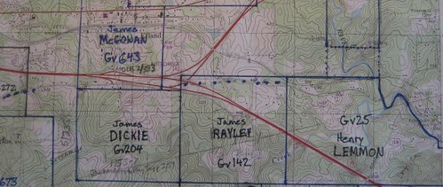
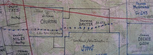
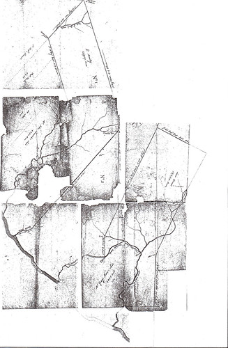
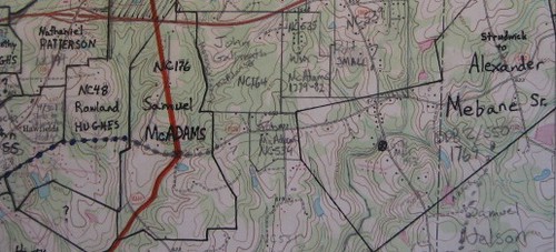
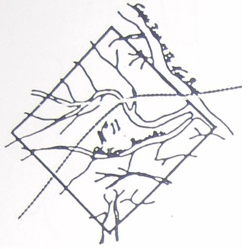
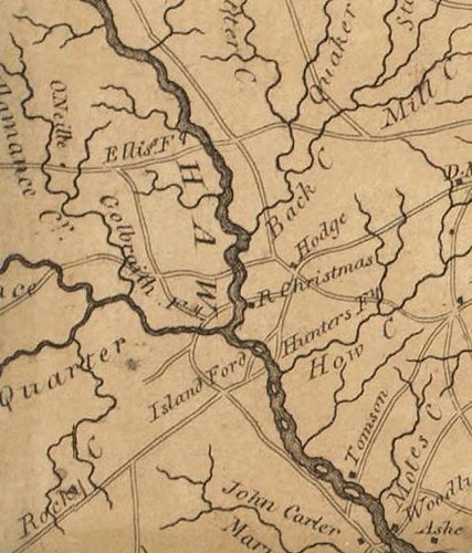
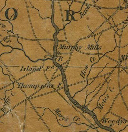
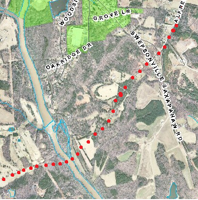
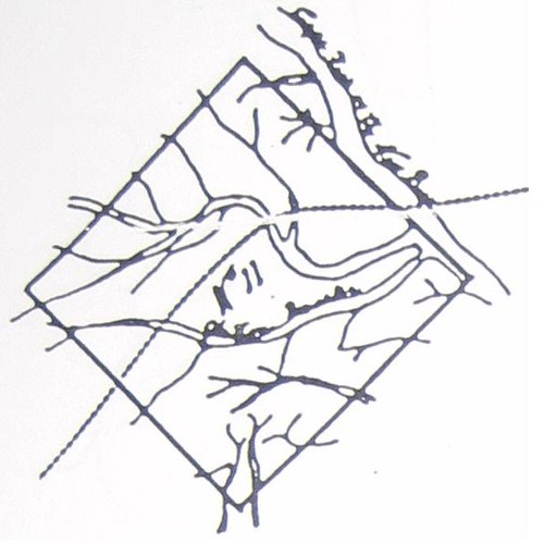
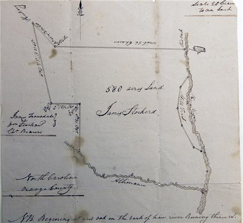
Location of McCulloh's Great Tract 11

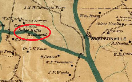
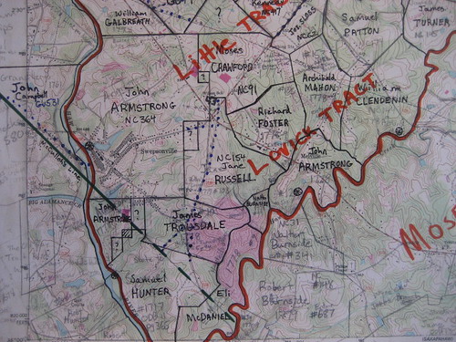
Tract 11 was a square rotated 45 degrees forming a diamond. It was 12.5 miles on a side, stretching from the old Rowan/Orange County line on the western tip to Swepsonville on the eastern end. Thus Tract 11 included big parts of what are now Alamance and Guilford Counties as well as small parts of Chatham and perhaps Randolph Counties. Tract 12 was in what are now Durham and Granville Counties and we shall discuss that tract another time (also a 12.5x12.5 mile square, but rotate 35 degrees instead of 45).

The Death of Granville

Under the terms of the 1761 agreement, McCulloh was to have to the sooner of the end of 1763 or until Granville's death to sell lands that conflicted with the Granville District. Granville died in January of 1763, cutting McCulloh's time by almost 50%. Davenport points out that there were numerous deeds after Granville's death but supposes that these deeds were purusant to contracts made before Granville's death. I cannot help but wonder whether the contracts were merely back-dated.

H. E. McCulloh's Deed of Surrender to the Granville Estate

When Henry E. McCulloh surrendered to Granville's estate the unsold lands in McCulloh's Great Tract #11, he listed out all of the parties to whom his father Henry McCulloh had sold land in Tract 11. Davenport lists all of these as an interesting record of who all the purchasers in Tract 11 were:

1. George Clapp, 320 acres, 20 sep, 1757

2. David Low, 350 acres, 8 Mar, 1758

3. Peter Helton, 320 acres, 11 Mar, 1758

4. Frederick Brown, 233 acres, 11 Mar, 1758

5. William Piggott, 297 acres, 11 Mar, 1758; ODB3/95 part to John Wheeler; PatentBk19/449.

6. Joseph Boggs, 546 acres, 11 Mar, 1758

7. Charles Davis, 187 acres, 2 Aug, 1758; see ODB2/562 to Jeremiah Piggot; on Cain Ck.

8. Joseph Buckingham, 171 acres, 7 Aug, 1758

9. Benjamin Piggott, 160 acres, 7 Aug, 1758

10. James Woods, 200 acres, 8 Aug, 1758

11. John McGee, 305 acres, 8 Aug, 1758

12. Thomas Low, 320 acres, 8 Jun, 1759; ODB3/333&334 HM to Lowe to John Powell; lots in town laid out by Lowe waters Stinking Quarter. Also ODB3/335 lot to Jacob Reason.

13. John Graves, 387 acres, 9 Jun, 1759; ODB6/5 to John Effland, p/o HM to John Graves, 129 ac Stink/4

14. Jacob Boon, 200 acres, 27 Feb, 1760

15. Frederick Siving, 159 acres, 15 Nov, 1760

16. Richard Brownrigg, 992 acres, 1 Dec, 1760

17. John Graves, 270 acres, 2 Dec, 1760

18. Elias Powell, 143 acres, 24 May, 1761

19. George Fogelman, 208 acres, 24 May, 1761; ODB 2, pg 503; stinking Quarter Ck

20. Michael Holt jr, 510 acres, 14 Nov, 1761

21. Anthony Moser, 220 acres, 8 Sep, 1762

22. Peter Noe, 507 acres, 8 Sep, 1762; ODB3/503 HEM to Noe to John Bounce 100 ac Thos 23. Rich's corner. Also ODB3/299 John Noe to Jacob Graves 1/2 of mill & 10ac on Stinking Quarter part of HEM to Peter Noe.

23. Adam Smith, 320 acres, 9 Sep, 1762;ODB3/361 part of HM to Smith, Joseph Revoner to Eadon Smith part of 320 ac. Not part of same proeprty, but see ODB3/138 Jas Williams to Michael Holt begin at Adam Smith Corner NxxW 23.5 ch. N45E 72 ch S45E 35 to Gt road Hboro to Salisbury to first station, waters Stinking 1/4 adjoin Samuel Suther, Philip Foust, Tobias Smith, J Perkins and prop formerly HEM now State. Also ODB4/423.

24. John Barton, 1000 acres, 9 Feb, 1762; 'On July 26, 1764 Conrad Staley bought 125 acres on Stinking Quarter Creek from Wiliam Barton, whose father John had bought a 1,000 acre tract from Henry McCulloch et al in 1760.'-google. Guilford DB 1/21 Martin Staley & wife Elizabeth to Jacob Staley, 26 Jul 1771, 40 ac on waters of Stinking Quarter, part of tract to Staley from William Barten, part of John Bartan to William Bartan, McCulloh to John Barton, orig tract 1000 ac, this part adj third corner of orig tract, branch, orig line. GDB 1/352 Jacob Stalley & wife Barbara to Martin Stally, 12 May 1775, on waters of Stinking Quarter, part of William Barton to Martin Stally, part of John Burton to Wm Barton, part of 1000 ac to John Barton, adj McCullohs orgi line, Barton's orig line. GDB 1/49 John Barton & wife Elisabeth to Jacob Stealy, 26 Jul 1771, 45 ac on waters of Stinking Quarter, part of Henry McCulloh grant of 1000 ac 9 Jan 1762.

25. James Powell, 200 acres, 9 Sep, 1762; ODB6/73 part to Elias Powell.

26. John Powell, 907 acres, 13 Oct, 1762; see ODB2/368 Powell to Wm Oneal to Phillip Albright; Ludwick Albright's line. ODB5/13 William Oneal to Phillip Albright 150.5 Ac both sides Haw R begin on Philip Albright's old line, N45E 21 p, N45W 100p, N45E 16 p, N45W 52 P, S45W 158 P, S 45 E 59 P to Phillip Albright's old line, N4E 155 (poles?) to first station; p/o tract HEM to John Powell no date; ODB 6/112 part to John Holt jr; also ODB6/115 part to William Dixon; OD6/69 to Ludwick Albright

27. John Grayson, 200 acres, 10 Sep, 1762;

28. Benjamin Phillips, 250 acres, 10 Sep, 1762

29. Peter Low, 200 acres, 10 Sep, 1762

30. John McGee, 401 acres, 10 Sep, 1762

31. Peter Eiffland, 210 acres, 11 Sep, 1762

32. William McMath, 200 acres, 11 Sep, 1762

33. Adam Lawrance, 320 acres, 11 Sep, 1762

34. Paul Harmon, 228 acres, 11 Sep, 1762; HM to Paul Herman 9/11/1762 to Peter Herman to 35. George Foust ODB 4/186; on Gt Alamance.

36. John Holt, 200 acres, 11 Sep, 1762

37. Isaac Grayson, 907 acres, 11 Sep, 1762

38. John Phillip Clapp, 202 acres, 11 Sep, 1762

39. Jeremiah Piggott, 209 acres, 13 Sep, 1762

40. David Low, 302 acres, 12 Sep, 1762

41. George Coble, 202 acres, 13 Sep, 1762

42. Jacob Coble, 202 acres, 13 Sep, 1762

43. Samuel Low, 250 acres, 13 Sep, 1762

44. John Oliver, 562 acres, 13 Sep, 1762; see ODB2/492 to Peter Courtney; Gt Alamanace; 45. George Fogelman's line.

45. Peter Poor, 202 acres, 14 Sep, 1762

46. Nicholas Counts, 250 acres, 14 Sep, 1762

47. Nicholas Holt, 275 acres, 16 Sep, 1762

48. Hugh Smith, 467 acres, 16 Sep, 1762

49. John Fuller, 200 acres, 13 Sep, 1762

50. Peter Holt, 200 acres, 17 Sep, 1762

51. David May, 327 acres, 13 Sep, 1762

52. Henry Whitsell, 202 acres, 17 Sep, 1762

53. Peter Gevell, 202 acres, 18 Sep, 1762

54. Archibald Morrison, 432 acres, 13 Sep, 1762

55. Barnard Clapp, 1122 acres, 18 Sep, 1762

56. Ludowick Clapp, 360 acres, 18 Sep, 1762

57. Malachy Isley, 200 acres, 14 Sep, 1762; ODB4/194 Isley to Phillip Foust to John Albright; Daniel may's Corner; Joseph Bogg's line; Greeson's Corner.

58. Ludowick Isley, 257 acres, 14 Sep, 1762

59. Henry Sharp, 216 acres, 8 Oct, 1762

60. John Shady, 200 acres, 7 Oct, 1762

61. Richard Henderson, 200 acres, ------, ---; ODB3/204 HM to Henderson 1/12/1760 to William Piggott; 240 ac; waters Rocky R; s/s Haw R.

62. Hames Vestal, 183 acres, ------, ---

63. Thomas Bramston, 577 acres, ------, ---

64. Jesse Pugh, 147 acres, ------, ---

65. Robert Stewart, 207 acres, ------, --- see part sold ODB2/593 Stewart to Thomas Canby to Edmund Fanning; Thos. Davis line; 1769. Also other part ODB2/560 Stewart to Thos Davis to Jeremiah Piggot; Cain Ck.

66. Joseph Welts, 513 acres, ------, ---

67. John Marshall, 216 acres, ------, ---

68. Michael Wolf, 250 acres, 4 Oct, 1762

69. Jacob Housman, 200 acres, 2 May, 1763

70. George Sharp, 214 acres, 13 May, 1763

71. Peter Ream, 202 acres, 4 May, 1763

72. Gasper Bare, 202 acres, 16 May, 1763

73. Nicholas Puntrick, 1386 acres, 16 May, 1763

74. Jacob Withrow, 1692 acres, 16 May, 1763

75. Barnard Troxell, 732 acres, 16 May, 1763

76. George Ingle, 258 acres, 17 May, 1763

77. Martin Loy, 251 acres, 17 May, 1763; apparently he built a mill on Rock Creek.

78. Phillip Sellers, 223 acres, 1 May, 1763

79. John Noe, 308 acres, 23 May, 1763; see ODB 2, pg 193; Noe to John Graves; Gt Alamance; 80. Phillip Seller's corner; Potmaker's line; cross Stinking Quarter; HEM to John Noe 1764 ODB 2, pg 576; Stinking Quarter Ck.

81. James Woods, 565 acres, 20 May, 1763

82. Andrew Campbell, 487 acres, 23 May, 1763

83. Dial Povey, 330 acres, 23 May, 1763

84. John Armstrong, 573 acres, 22 May, 1763

85. Frederick Moser, 225 acres, 24 May, 1763

86. William McMath, 513 acres, 25---, 1763

87. Christian Funkhouser, 1240 acres, 18 May, 1763

88. Peter Julian, 247 acres, 30 Sep, 1763

89. John Beverly, 200 acres, 3 May, 1763

90. Samuel Underwood, 305 acres, 30 May, 1763

91. H & A Underwood, 333 acres, 30 May, 1763; ODB4/712 HEM to Allexander Underwood and State to underwood to Nathan Hornaday 300 ac headbranches Rock Ck. Alex U to Christopher Hornaday ODB5/381 borders Hiatt, Stewart, Purgh, Marshall and Pyke.

92. Conrad Stoner, 225 acres, 1 Jun, 1763

93. Ludowick Albright, 258 acres, 1 Jun, 1763

94. John Holt, 215 acres, 24 May, 1763

95. Jacob Boon, 200 acres, 24 May, 1763 see ODB 2, pg 494 sold to Adam Whitesil; John Shadey's corner.

96. Henry Camira, 300 acres, 26 Jun, 1763

97. John Butler, 414 acres, 6 May, 1763

98. Christian Hoffman, 290 acres, 30 Jun, 1763; nearby deed ODB4/652 JohnHuffman to Adam Whitsell, Gun Ck; just outside Tract 11?

99. George Clapp, 362 acres, 8 May, 1763

100. Samuel Underwood, 200 acres, 20 Jun, 1763

101. Aaron Sharp, 266 acres, 1 May, 1763; ODB7/258 185 ac to George Foust.

102. Thomas Reck, 430 acres, 31 May, 1763

103. Samuel Oliver, 203 acres, 6 Jun, 1763

104. Abraham Helton, 210 acres, 25 May, 1763

105. Thomas Fuller, 260 acres, 10 Jun, 1763

106. John Marshel, 500 acres, 6 Jun, 1763

107. Andrew Rudolph, 388 acres, 8 Jun, 1763. GDB 1/83 Anthony Coble & wife Mary to Nicholas Coble, 8 Feb 1772, 194 ac on waters of Stinking Quarter, Henry McCUlloh to Andrew Rudolph 8 Jun 1763, adj 3rd corner of orig tract, John Coble.

108. Joseph Wells, 208 acres, 6 Jun, 1763; see ODB2/422 to Nathan Wells; William Marshall's line; N/S Cane Ck; crossing creek; part of 2 tracts HEM 6/7/1765 & 4/16/1760. Also ODB4/662 part to John Thompson of Chatham. ODB5/240 Wells to Levi Gifford; s/s Cain Ck?; William Marshall's line; John piggott's line. see also ODB5/247&433.

109. Thomas Wiman, 202 acres, 2 Jun, 1763

110. Charles Adams, 297 acres, 20 Oct, 1763; ODB5/78 Robert sr to jr Gt Alamance; Trousdale line; partly from HEM, Charles Adams and State. ODB5/79 very similar.

111A. Robert Hunter, 316 acres, 12 Oct, 1763; ODB4/678 HEM to Robert Hunter (9/22/1762 ???) to Matthew Hunter begin at bank of Haw S75W 220p, N81W 225 P to corner Robt Ray near the Potters Old Field alond sd line N75E 240p to whiteoak on River dwon meanders; 316 ac.

111. Bartholomew Dunn, 1590 acres, 7 Jun, 1763.

112. Joseph Trotter, 516 acres, 7 Jun, 1763

113. Alexander Tansey, 304 acres, 8 Jun, 1763

114. Michael King, 256 acres, 7 Jun, 1763; ODB3/146 John Smith to John Long & John Clark 184 ac; waters of Stinking Quarter; "to Michael King from Henry McCulloch 2 June 3rd yr reign Geo III"; Bennett notes this is not in the deed to Granville's estate probably because Davenport transcribed the name as Michael Iling. part of same tract Peter Richardon to John Morice 72 ac; waters Stinking Quarter. HM to King 6/1/1762 256 ac.

115. George Coble, 360 acres, 8 Jun, 1763

116. Fr. Leinberher [Leinburgerer, Leinberger], 554 acres, 10 Jun, 1763

117. George Counts, 222 acres, 8 Jun, 1763

118. Jacob Leinburgher, 242 acres, 9 Jun, 1763. GDB 1/271 Jacob Leinbarger & wife Catherine  to Francis Lienbarger, 6 Feb 1773, 121 ac part of tract from Henry McCulloh 9 Jun 1763 for 242 ac.

119. John Linn, 410 acres, 9 Jun, 1763

120. Joseph Clapp, 620 acres, 30 Jun, 1763

121. Charles Adams, 200 acres, 24 Jun, 1763

122. Frederick Low, 932 acres, 27 Jun, 1763

123. Anthony Coble, 450 acres, 18 Jun, 1763; see ODB2/49 HEM to Coble 307 ac; boths ides Pitmans Ck; SW line of Great Tract; a corner of HEM [sub-]tract 5.

124. Ludowick Surig, 370 acres, 25 Jun, 1763

125. John Nutts, 268 acres, 24 Jun, 1763

126. Adam Whitsell, 706 acres, 22 Jun, 1763

127. Robert Lindsay, 407 acres, 24 Jun, 1763

128. Henry Whitsell, 200 acres, 24 Jun, 1763

129. John McComb, 280 acres, 24 Jun, 1763

130. Michael Holt, 300 acres, 21 Jun, 1763; ODb5/526 to barnett Troxler 37 ac. s/s Gt Alamance; John claps corner.

131. John Barber, 479 acres, 9 Jun, 1763

132. John Coble, 355 acres, 22 Jun, 1763

133. William Davis, 200 acres, 25 Jun, 1763

134. Henry Strade, 200 acres, 20 Jun, 1763

135. George Courtney, 494 acres, 25 Jun, 1763

136. John Grayson, 531 acres, 28 Jun, 1763

137. George Leingurger, 242 acres, 28 Jun, 1763

138. Nicholas Grayson, 243 acres, 25 Jun, 1763

139. Joseph Peary, 744 acres, 23 Jun, 1763

140. Peter Helton, 217 acres, 28 Jun, 1763

141. George jr Coble, 200 acres, 28 Jun, 1763

142. J P Clapp, 200 acres, 25 Jun, 1763

143. Jacob Albright, 215 acres, 10 Jun, 1763; ODB4/181&182 to Henry and Daniel Albright; Rock Ck near John Loy's Mill. see patent Bk57/86. Also ODB 4/470 Loy's Millpond.

144. Tobias Clapp, 200 acres, 26 Jun, 1763

145. James Davison, 616 acres, 18 Jun, 1763

146. John Bracken, 200 acres, 28 May, 1763

147. Manfield Crow, 992 acres, 25 Jun, 1763

148. Henry E. McCulloh, 1320 acres, 20 Nov, 1763

149. Henry E. McCulloh, 1120 acres, 20 Nov, 1763

150. Henry E. McCulloh, 1000 acres, 20 Nov, 1763

151. Henry E. McCulloh, 1856 acres, 1 Jun, 1763

152. Henry E. McCulloh, 1125 acres, 20 Apr, 1763

153. Henry E. McCulloh, 1542 acres, 20 Apr, 1763

154. Henry E. McCulloh, 1300 acres, 3 Jun, 1763

H E McCulloh's deed of surrender lacks any information about where within the tract these persons were, but it is likely a fairly comprehensive list. In some cases I have added above references to Orange and Guilford County Deed Books which tend to confirm the transactions or clarify where the property was. I reviewed up through and including ODB 16 and GDB 2, but there are clearly many other subsequent deeds.

McCulloh Deeds Not Listed in the Surrender to Granville
However, the grant from Henry Mcculloh to William O'Neal (12/20/1760) which is documented in the further conveyance to Jacob Grave (ODB 4/164) on Stinking Quarter Creek does not seem to match any of the HEM exceptions in the Granville surrender.

Others

There are a number of other Henrey Eustace McCulloh transactions, which apparently relate to the thousands of acres deeded from Henry McCulloh to his son at the last minute:

ODB 4/560 John Peek to John Marshall 5 ac part of 230 ac to John Pike, Henry [E?] McC, John Campbell & Alexander McCulloh on Cain Ck John Marshal's line on north John Pike's line on east.

Armstrong, HEM, Trousdale ODB 2, pg 584; Swepsonville mill site.

ODB4/693 John Ray to George Foust 150 ac p/o larger tract HEM to Wm Ray sr./ Gt Alamance begin mouth of branch S18E 20ch, S41E 11 ch, S11W 25 ch, W 30.5 ch to Foust's line near his corner, N4W? 25 ch to a creek James Latta's corner near mouth of Little Alamance Ck to first station. ODB6/167 Martha Ray widow to John Holmes, J Lindleys line, p/o larger tract HEM to William Ray.

ODB4/340 HEM to John Huffman 12/28/1773 both sides Cedar Ck.

Julian, Peter Sr – GDB 1/216 Peter Julien Sr miller & wife Ann to John Emack, 18 Jan 1773, 247 ac on S Fk Allamance, adj branch, Thomas Kinman; part of Henry McCulloh to Julien 18 Jan 1771.

England, ____ - GDB 1/232 Robert Field & wife Ann to Daniel England, 14 Apr 1774, 200 ac on S Fk Allamance in McCulloh Tract #11, McCulloh to England 25 Jun 1763.
GDB 1/90 Ralph Gorrell storekeeper to Martin Boon planter, 25 Dec 1771, 251 ac adj Christian Funkhowser, Cedar Ck, Lodwick Iselys corner, corner of small tract called number 38 of the McCulloch tracts.

Isley, Ludwick – GDB 1/237 Henry Eustace McCulloh to Ludowick Isley, 1 Jan 1773, 250 ac adj corner of Christian Founkhauser Granvilles line, Cedar Ck.

Whitsell, Christian – GDB 1/204 Henry Whitsel to George Nees, 10 Feb 1773, 238 ac on S side Great Allamance, part of Henry Eustace McCulloh to Whitsell.

Cuntz – GDB 1/142 Nicholas Cuntz & wife Mary to Thos McCollok tanner of Orange, 7 May 1772, 250 ac in counties of Guilford & Orange, mostly in Guilford, on Stinking Quarter Ck, part of No 11 from McCulloh to Cuntz 14 Sep 1762, adj 2 rocks on a hill, Spring Br.

Creson, John – GDB 1/81 John Creeson & wife Hannah to Christian Fouse, 7 Sep 1771, 200 ac on Great Allamance Ck, part of large tract belonging to Henry Eustace McCulloh called No 11, on branches of Har R Henry Eustace McCulloh to John Creson 10 Sep 1760, on Great Allamance Ck.

Irving, Ludwick – GDB 1/356 Ludewick Irving farmer & wife Eve to Geroge Cotner, 9 Sep 1774, 190 ac on waters of Stinking Quarter Cl, part of Henry McCulloh to Ludwick Irving in 1763, adj orig line.

Kinman, Thomas – GDB 2/418 James Kinman & wife Jean to Elias Cowen, 23 Mar 1784, 202 ac on Alamance, adj stake on the top of a hill; given to him by his last will of his father Thos Kinman, Henry Eustace McCullock toThomas Kinman 2 Jun 1763, commonly known by No Eleven.

Dunn, Bartholomew – GDB 1/357 Henry Eustace McCulloh to Bartholomew Dunn planter, 21 Apr 1765, 200 ac adj John McGees corner, Barton, corner of McCulloh’s 1300 ac tract, Earl Granville’s line. GDB 1/354 Bartholomew Dunn planter & wife Elizabeth to Jacob Staley, 2 Apr 1773, 200 ac on waters of Sandy Ck, adj John McGee’s corner, Barton, opposite McCulloh’s 1000 ac tract, Granville’s line; HEM to Dunn 21 Apr 1764 [sic].

Lowe – GDB 1/243 David Lowe & wife Mary to William Plunkett, 9 May 1774, 255 ac, HEM to Lowe 23 Feb 1765 for 355 ac on N Fk of Stinking Quarter Ck, adj Samuel Lowe, Hugh Smith’s corner, that part of land under waters of Mill Pong on creek excepted out of conveyance to David Lowe. GDB 1/393 David Lowe & wife Mary to Philip Seller, 20 Nov 1775, 100 ac, part of HEM to Lowe 23 Feb 1765 for 355 ac, adj end of the 6th line, outlines of sd land reverst.

Funkhouser, Christian – GDB 1/130 William Wiley to Thomas Cummings, 12 Feb 1772, 250 ac in Guilford, formerly Orange, adj Nicholas Pundrick’s corner, Cedar Ck; McCulloh to Christian Funkhouser. GDB 1/194 Thomas Cummins & wife Marian to Peter Sallinger [Sullinger] of Chatham, 9 Nov 1772, 251 ac where Cummins now dwells, adj Nicholas Puntricks corner; part of larger tract from McCulloh to Christian Funkhausen.

State Grants of Confiscated Henry E. McCulloh Lands

I skipped (for now) state confiscation deeds for HEM lands.

Sunday, January 24, 2010

Great Tract #11 and the Haw River

So far as I can tell, no formal legal description of Henry McCulloh’s Great Tract #11 has survived to the modern day. We have a copy of a map that shows all twelve of McCulloh’s Great Tracts, originally drawn by Matthew Rowan and retraced a few years ago by the late Charles Holleman of Raleigh (the original being very inaccessible in a private collection in England. Here’s how the Holleman Tracing looks as reprinted in the North Carolina Genealogical Society Journal:

McCullough's_Great_Tract__11

[If you are missing part of the picture on the east, you can click through to see the complete image.]

As shown, the diamond shaped Tract 11 does not appear to include land on the east side of the Haw River. However, the drawing cannot be taken literally, as the land and rivers are very schematic, not to scale.

According to Fred Hughes, the western extremity of this massive tract just about touched the old Rowan/Orange County line on the west. A 100,000 acre square is exactly 12.5 miles on a side and relying on Fred Hughes’s Historical Documentation: Guilford County, I measure (using Google Earth) that Tract #11 cut across the Haw River into a slice of the Lovick Tract, just missing any part of the Little Tract – which if correct would put the Swepsonville millsite distinctly outside Tract 11, though just barely.

However this would be a troubling conclusion. All of the documents involved in selling the mill from John Armstrong to John Trousdale show that the underlying title was Henry Eustace McCulloh’s. An agreement in the Armstrong Papers at the Southern Historical Collection shows that in July 1764 Armstrong agreed to build a saw mill and operate it. He was to pay 50 pounds a year to Henry Eustace McCulloh and at the end of 4 years McCulloh was to deed him a 1/2 undivided interest in the mill. This seems to have transpired as planned and McCulloh and Armstrong jointly sold the mill to John Trousdale only a few years after Armstrong's 50% interest vested. Yet the Armstrong/Trousdale mill site seems to be just north of the McCulloh line, putting it outside of McCulloh's Great Tract #11.

Land Grants on the West Bank

In order to more precisely fix McCulloh's S45E line as it intersected the Haw River, let's take a look at the Granville grants for that area (Granville's records being far more complete than McCulloh's).

John Campbell

This 1761 Granville grant to John Campbell is an obvious place to start:

Closeup of John Campbell 1761 grant

The textual description of this tract refers to the S45E line here as “a line called McCullock’s” and the survey clearly shows one of the Trading Path fords on the Haw River. An important question, then, is which ford on the Haw this was. As I will show in a moment, this was definitely the ford at Swepsonville.

Conrod Long

Another interesting grant in that area is Orange Co. State Land Grant #167 to Conrod Long (below). Long's State Grant was dated 1779, but he was probably on this property much earlier. As the survey clearly shows Nelson Branch ran through and just off the south edge of this property.

Conrod Long Plat

My Historical Atlas of the Haw River says “John Hopkins, Samuel Shaw and William Galbreath all ran ferries near the mouth of Back Creek (Orange Court of Pleas and Quarter Session Minutes for May 1780, Feb 1783, May 1783 and Feb 1784).” I didn’t cite it in the Atlas, but there are deeds from Hopkins to Shaw conveying two parcels on opposite sides of the Haw River, recorded at Deed Book 2, pg 363 and 364 (1783). The deed for the west side of the Haw (page 364) reads “begin at a sweet gum on Nelsons Creek . . .” demonstrating that Nelson's Creek or Branch is the creek directly opposite the mouth of Back Creek. Using that reference point and the Conrod Long grant, we can sketch Mr. Long's farm onto a modern topo map.

William Phillips

Conrod Long’s grant indicates that the property owner to the south of him was named Phillips. This appears to have been William Phillips, who received a Granville grant in 1761 for 700 acres on the west side of the Haw (#538). The accompanying survey (shown below) plainly shows a creek flowing into the Haw, but neither the survey nor the legal description mentions the name.

Closeup of Wm Phillips grant 1761

I assume that this is Nelson Creek as shown on the Conrod Long grant and that William Phillips is the Phillips mentioned in the legal description of Long's grant. It is also notable that the 1761 grant to John Campbell refers to the property owner to the north as being Phillips. Note also that Campbell’s northern line was 81 chains from the Haw River due west to McCulloh’s line and Phillips southern boundary was also 81 chains due west from the Haw (and the next call of Phillips’s deed is N45W – a perfect match to McCulloh’s line, although McCulloh is not mentioned in the Phillips grant).

Putting It All Together

Thus, Conrod Long was just north of Nelson Branch. To the south of Long was William Phillips straddling the mouth of Nelson Branch, directly opposite Galbreath and Hopkins at the mouth of Back Creek. And to the south of Phillips was John Campbell. Mapping all three of these land grants together, it is clear that John Campbell’s grant was immediately opposite what would later be the textile mill in Swepsonville, with his southernmost corner being about 15 chains above the confluence of Big Alamance Creek and the Haw. Thus it would seem that the McCulloh line intersected the Haw River immediately south of the mill site at Swepsonville, rather nicely corroborating the result I got from projecting the location based on Historical Documentation: Guilford County.

The Mill Petitions

The Orange Court of Pleas and Quarter Sessions minutes for August 1761 record that John Campbell petitioned for permission to build a gristmill on the Haw River – just a few weeks before Campbell received his grant from Granville on 8/23/1761. However, notably Campbell’s mill petition was rejected and he gave notice of appeal to Halifax Court. It would be interesting to see if Halifax Court records of this case still exist.

In August 1763, the Orange Court of Pleas minutes show that Henry Eustace McCulloh condemned land of Robert Nugent in order to build a mill on the Haw River opposite land owned by McCulloh. My interpretation is that this petition relates to the same site as John Campbell's petition and that Henry Eustace McCulloh was a successor in interest to Campbell. This seems especially plausible because John Campbell was one of Henry McCulloh's agents in North Carolina. Henry spent most of his time in England and transacted business in North Carolina through some close associates to whom he granted Powers of Attorney. The surviving POA's name Henry's son Henry Eustace McCulloh, Alexander McCulloh and John Campbell (5 Colonial Records of North Carolina 779-782; 6 CR 532-536).

In other words, I think John Campbell obtained his Granville grant on behalf of Henry McCulloh (or Henry Eustace McCulloh) and merely held the property in trust for him; that might sound like an odd arrangement today, but it was a common method of operation for the McCullohs. All of this would explain how Henry Eustace McCulloh came to sell John Trousdale a mill site just outside of Tract 11.

Robert Nugent

This theory has left me with another curious question: Who was the Robert Nugent from whom McCulloh was condemning land? He must have owned the land that later became the Armstorng/Butler Tract - the east bank of the Haw at the Swepsonville mill site. But the Orange County Deed Books show no deeds to or from Robert Nugent - or any Nugent for that matter. Neither does the name Nugent appear in William D. Bennett's index of Orange land records (which includes the Granville papers). In fact, I cannot find any sign of Robert Nugent in any source related to 18th century Orange County.

The only clue I have come across is that there was a Robert Nugent in England who was oneo fthe Lords of Treasury in 1754. Perhaps Robert Nugent was the person who obtained supposed title to the Forster, Little and Lovick Tracts from former Gov. George Burrington. Burrington had nominally owned 40,000 acres in the Hawfields just east of Tract 11, but only 30,000 acres of that passed to Samuel Strudwick. The title to the other 10,000 acres has never been accounted for, although the area where that 10,000 acres lies is along the Haw River between the mouths of Back Creek and Big Alamance Creek - in other words all around Swepsonville.

James Stockard

The land on the west bank of the Haw above Alamance Creek eventually escheated to the University of North Carolina and was sold to James Stockard:

sweponsville doc 1=4

Stockard's 580 acres here includes almost all of the 1761 John Campbell grant (exceptin part carved out for 'the mill tract') as well as a a part of Tract 11. Notably Stockard's deed mentions that the property owner to the north is Phillips, quite consistent with our interpretation of the location of the Campbell grant. Much of this property eventually became a part of Archibald Debow Murphey's estate, The Hermitage.