Here's an interesting description of Swepsonville, NC in the 19th century. It came from The light of four candles by Cardenio Flournoy King (1908). Mr. King's mother was defrauded of her late husbands estate . . .
Sixty miles to the eastward was the little town of Swepsonville, in Alamance County—a Southern cotton-mill town. Mother was forced to go there, that the older children might work. She helped keep the family purse filled by taking boarders. We all worked as soon as we were able. I was a bobbin boy at ten.
There were four hundred hands in the mill, which was a three-story frame structure, and it ran night and day with two shifts. Its machinery was idle only from midnight Saturday night to midnight Sunday night. I was in the night shift. As I remember it, it did not seem to be especially unpleasant. I recall but one painful incident—being knocked across the room by a cruel overseer who found me asleep one night when I should have been at work.
We had religious services every Sunday in the saw-mill, Sunday school and occasional sermons from a Baptist preacher who came from the next town and preached for what he could raise in the collection box. We had singing lessons weekly. This was about the limit of our diversions.
They were good people in that town. Everybody was kind and generous. Everybody was hard-working. I think everybody was religious. The favorite tune sung or whistled was "In the Sweet Bye-and-Bye." I have sometimes wondered, since I grew up, if that was because they had very little to look forward to in this life.
Then came Swepsonville's calamity. The entire population, aroused by the loud clang of the bell on the hill, went up one night and stood in horror, watching the mill burn to the ground.
George W. Swepson, of Raleigh, the owner of the mill, was in town. I knew him quite well, for he boarded at our house when he was in Swepsonville, and I want to depart from the thread of my story just long enough to pay his memory a warm personal tribute. He was a good man, a strong man, a Southern gentleman. He appreciated the humanity of his employees and was interested in them personally. There was none of the soulless magnate about him. The people in his town admired him, respected him and loved him.
I worked my way through the crowd, at eleven or twelve o'clock that night, and stood beside George W. Swepson. Then and there I received my first lesson in bearing up under adversity, in turning defeat into victory. Standing there in the glare of the burning mill, which meant a terrible loss to him, Mr. Swepson made a drawing for the new mill which should be erected upon its ashes, and while the sparks were still shooting heavenward he gave orders to his general superintendent, Monroe Cooke, to order the materials from which the next structure, to be of brick, should be constructed.
This was on Thursday or Friday, and on Monday morning the brick yard was started. Left without a position by the destruction of the mill, I applied for work at the kilns and was given a place as brick bearer, at twenty-five cents a day.
For some weeks I bore brick from the molders to the sun-drying places. I earned a dollar and a half a week and turned it over to my mother. Then there came a day when she realized that the family was not earning enough to support itself. Some of us must go away from home, out into the world where wages were higher and opportunities greater. I was one of those to go and with four dollars in my pocket and my shoes in my carpet-bag I crossed the high bridge and struck out for the railroad and that fortune I never doubted I should some day have.
Saturday, October 24, 2009
Proceedings of the Good Roads Institute 1911
Continuing our NC Piedmont travel description series, here is the relevant portion of the Proceedings of the Good Roads Institute 1911, by Joseph Hyde Pratt and Hattie M. Berry:
From Durham to Graham, Alamance County, two routes are available —one, via Hillsboro (see Fig. 2), the county seat of Orange County, and the other, via Chapel Hill (see Fig. 3), Orange County.
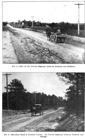
[Fig.2 is essentially Old NC 10/US 70; Fig. 3 is Old Chapel Hill-Durham Road, just south of US 15-501]
At the present time the best route is via Chapel Hill. From Durham to the Orange County line the road is macadam and from the line to Chapel Hill it is sand-clay. There are a great many beautiful vistas along this road, and, when within one mile of Chapel Hill and immediately after crossing an iron bridge [Bolin Creek], the road begins to climb a long hill [Strowd Hill on Franklin Street in CH] (on an easy grade, however), which is the first hill climbing of any extent that the traveler has encountered since leaving Morehead City. When the top of the hill is reached a splendid view greets the traveler, and he can see across the broad valley nearly as far as Raleigh.
Chapel Hill, the seat of the State University, is located on the summit of a long, high hill, and the highway passes through the main street of the town. Entering from the east, the broad street, with its beautiful homes and well-kept yards on each side, gives some idea of the beauty and dignity of this delightful old town. Sufficient time should be taken to ride through the campus of the oldest State University in the country. Just before reaching the center of the town, the Episcopal Church will be passed. This beautiful, ivy-covered building [Chapel of the Cross] attracts the attention of all who pass and reminds one of old English churches. It was designed by Upjohn, the architect who designed Old Trinity Church of New York.
As one leaves Chapel Hill and rides toward Saxapahaw, Alamance County, he realizes that he has entered the rolling and hilly country of the Piedmont Plateau region. [No mention of Carrboro!]The highway, however, will take the hills by easy grades and the scenery claims the attention of the traveler for the whole distance. [Just as true 98 years later!] At Saxapahaw the road twines down to Haw River, which is crossed on an iron bridge. This little mill town, situated about 9 miles from a railroad, is a city unto itself.
The road from Saxapahaw to Graham has just been completed and is partly sand-clay and partly macadam.
The other route from Durham to Graham, via Hillsboro, passes through West Durham, where the large Methodist College (Trinity) [Duke University, obviously] is located. The road to the Durham line will be macadam and across Orange County it will be gravel or sand-clay. [This is Old NC 10/US 70.] Within a few miles of Hillsboro the road passes through two of the noted farms of the State, the Duke farm and the Occoneechee farm. Hillsboro was formerly the capital of the State, and contains many very attractive old homes.
Cornwallis began the construction of paved roads at Hillsboro during the year 1780 of the Revolutionary War, when he had his army quartered for the winter at that place. At the time the roads were practically impassable and he had his soldiers fill the mudholes with rocks. While it did not make a smooth or good road, it did make them passable, so that he was able to haul his cannon and wagons. Some of Cornwallis's road improvement is still to be seen. Most of it, however, has been replaced recently by a good macadam. This old historic town is well worth a visit by the tourist, and most delightful accommodations can be had at the Corbinton Inn.
On leaving Hillsboro the road to Mebane is very hilly and rough, but a new location has been made and the new road should be finished within the next year.
At nearly every town that the highway passes through since leaving Raleigh are one or more cotton mills, and these mills continue to be conspicuous landmarks until the highway passes Mooresville and Statesville. At West Durham the Erwin Cotlon Mills represent the largest in the South and one of them covers a greater area than any other cotton mill in the country.
At Mebane is the plant of the White Furniture Company. This is the beginning of a series of furniture factories that will be observed in many of the towns from this point westward. From Mebane the highway passes through Haw River to Graham, where it intersects with the Chapel Hill road. On leaving Graham the traveler will find a splendid macadam road for a distance of 50 miles, passing through Burlington and Elon College, Alamance County, and Gibsonville, Greensboro, Jamestown, and High Point, Guilford County.
At Greensboro, the county seat of Guilford County, the Central Highway intersects the National Highway and the two highways coincide as far as Landis, Rowan County, 62 miles to the south. Good hotel accom- ' modations can be obtained in Greensboro, at the Guilford and McAdoo hotels. The State Normal College, the Greensboro Female College, and the A. and M. College for the colored race are located in this city. Guilford County received the $1,000 offered by the Atlanta Journal for the county south of Roanoke, Virginia, through which the National Highway passed that had the best roads. The county is keeping up its reputation and still has the best system of roads of any county in the State. The macadam road between Greensboro and High Point, 15 miles, has been treated with tarvia.
It was only a few years ago that High Point was a small village whose only distinction was the fact that it was the highest point on the Southern Railway between Danville and Charlotte. Now it is the second city in the country in the manufacture of furniture, the only city exceeding it being Grand Rapids, Michigan. Soon after leaving High Point the Highway enters Davidson County, and the roads during rainy weather have caused travelers a great many anxious moments. The route through this country has recently been resurveyed and the long hills have been eliminated. Revenue will also be available to convert the heavy clay road into a beautiful, smooth, sand-clay road.
People who have driven across Davidson County have not had an opportunity to appreciate the beauties of the county, as their thoughts have been too much centered on the road. Another six months will see the road in good condition, and then the traveler will realize that he is passing through a most delightful section of the State, where productive and prosperous farms are very numerous, and, with the beautiful views from the ridge and up the long rich valleys, will impress one that this county is one in which it would be good to live. Thomasville and the county seat, Lexington, are two rapidly growing towns of this section. Lexington Township has recently issued $100,000 in bonds for the construction of good roads.
Just before reaching the Yadkin River, which is the boundary line between Davidson and Rowan counties, the highway passes near the Daniel Boone Memorial Cabin, which marks the birthplace of that great American pioneer and noted character in American history. Yadkin River is crossed by a tollbridge, but plans are now under way to have a free bridge across this river. At the time of the Automobile Run from !N"ew York to Atlanta under the auspices of the New York Herald and the Atlanta Journal, this tollgate at the end of the bridge was the only tollgate that was raised without charging the tourists toll.
First-class sand-clay and macadam roads are again encountered as the highway reaches Rowan County. The steep hill immediately beyond the bridge will soon be a thing of the past. A new location has been surveyed for the highway, and the new road will be ready by spring. For the next 50 to 60 miles the highway is a joy to all who ride over it, smooth surface and easy grades. Spencer, where are located the large shops of the Southern Railway, is soon passed and Salisbury is in sight. This town, the county seat of Rowan County, is of historic interest in connection with scenes enacted during the Civil War. One of the Confederate prisons was located here. One of the Federal cemeteries is at Salisbury, and, during the past few years, several very handsome monuments have been erected by Northern States to the memory of their soldiers buried at this place.
From Durham to Graham, Alamance County, two routes are available —one, via Hillsboro (see Fig. 2), the county seat of Orange County, and the other, via Chapel Hill (see Fig. 3), Orange County.
[Fig.2 is essentially Old NC 10/US 70; Fig. 3 is Old Chapel Hill-Durham Road, just south of US 15-501]
At the present time the best route is via Chapel Hill. From Durham to the Orange County line the road is macadam and from the line to Chapel Hill it is sand-clay. There are a great many beautiful vistas along this road, and, when within one mile of Chapel Hill and immediately after crossing an iron bridge [Bolin Creek], the road begins to climb a long hill [Strowd Hill on Franklin Street in CH] (on an easy grade, however), which is the first hill climbing of any extent that the traveler has encountered since leaving Morehead City. When the top of the hill is reached a splendid view greets the traveler, and he can see across the broad valley nearly as far as Raleigh.
Chapel Hill, the seat of the State University, is located on the summit of a long, high hill, and the highway passes through the main street of the town. Entering from the east, the broad street, with its beautiful homes and well-kept yards on each side, gives some idea of the beauty and dignity of this delightful old town. Sufficient time should be taken to ride through the campus of the oldest State University in the country. Just before reaching the center of the town, the Episcopal Church will be passed. This beautiful, ivy-covered building [Chapel of the Cross] attracts the attention of all who pass and reminds one of old English churches. It was designed by Upjohn, the architect who designed Old Trinity Church of New York.
As one leaves Chapel Hill and rides toward Saxapahaw, Alamance County, he realizes that he has entered the rolling and hilly country of the Piedmont Plateau region. [No mention of Carrboro!]The highway, however, will take the hills by easy grades and the scenery claims the attention of the traveler for the whole distance. [Just as true 98 years later!] At Saxapahaw the road twines down to Haw River, which is crossed on an iron bridge. This little mill town, situated about 9 miles from a railroad, is a city unto itself.
The road from Saxapahaw to Graham has just been completed and is partly sand-clay and partly macadam.
The other route from Durham to Graham, via Hillsboro, passes through West Durham, where the large Methodist College (Trinity) [Duke University, obviously] is located. The road to the Durham line will be macadam and across Orange County it will be gravel or sand-clay. [This is Old NC 10/US 70.] Within a few miles of Hillsboro the road passes through two of the noted farms of the State, the Duke farm and the Occoneechee farm. Hillsboro was formerly the capital of the State, and contains many very attractive old homes.
Cornwallis began the construction of paved roads at Hillsboro during the year 1780 of the Revolutionary War, when he had his army quartered for the winter at that place. At the time the roads were practically impassable and he had his soldiers fill the mudholes with rocks. While it did not make a smooth or good road, it did make them passable, so that he was able to haul his cannon and wagons. Some of Cornwallis's road improvement is still to be seen. Most of it, however, has been replaced recently by a good macadam. This old historic town is well worth a visit by the tourist, and most delightful accommodations can be had at the Corbinton Inn.
On leaving Hillsboro the road to Mebane is very hilly and rough, but a new location has been made and the new road should be finished within the next year.
At nearly every town that the highway passes through since leaving Raleigh are one or more cotton mills, and these mills continue to be conspicuous landmarks until the highway passes Mooresville and Statesville. At West Durham the Erwin Cotlon Mills represent the largest in the South and one of them covers a greater area than any other cotton mill in the country.
At Mebane is the plant of the White Furniture Company. This is the beginning of a series of furniture factories that will be observed in many of the towns from this point westward. From Mebane the highway passes through Haw River to Graham, where it intersects with the Chapel Hill road. On leaving Graham the traveler will find a splendid macadam road for a distance of 50 miles, passing through Burlington and Elon College, Alamance County, and Gibsonville, Greensboro, Jamestown, and High Point, Guilford County.
At Greensboro, the county seat of Guilford County, the Central Highway intersects the National Highway and the two highways coincide as far as Landis, Rowan County, 62 miles to the south. Good hotel accom- ' modations can be obtained in Greensboro, at the Guilford and McAdoo hotels. The State Normal College, the Greensboro Female College, and the A. and M. College for the colored race are located in this city. Guilford County received the $1,000 offered by the Atlanta Journal for the county south of Roanoke, Virginia, through which the National Highway passed that had the best roads. The county is keeping up its reputation and still has the best system of roads of any county in the State. The macadam road between Greensboro and High Point, 15 miles, has been treated with tarvia.
It was only a few years ago that High Point was a small village whose only distinction was the fact that it was the highest point on the Southern Railway between Danville and Charlotte. Now it is the second city in the country in the manufacture of furniture, the only city exceeding it being Grand Rapids, Michigan. Soon after leaving High Point the Highway enters Davidson County, and the roads during rainy weather have caused travelers a great many anxious moments. The route through this country has recently been resurveyed and the long hills have been eliminated. Revenue will also be available to convert the heavy clay road into a beautiful, smooth, sand-clay road.
People who have driven across Davidson County have not had an opportunity to appreciate the beauties of the county, as their thoughts have been too much centered on the road. Another six months will see the road in good condition, and then the traveler will realize that he is passing through a most delightful section of the State, where productive and prosperous farms are very numerous, and, with the beautiful views from the ridge and up the long rich valleys, will impress one that this county is one in which it would be good to live. Thomasville and the county seat, Lexington, are two rapidly growing towns of this section. Lexington Township has recently issued $100,000 in bonds for the construction of good roads.
Just before reaching the Yadkin River, which is the boundary line between Davidson and Rowan counties, the highway passes near the Daniel Boone Memorial Cabin, which marks the birthplace of that great American pioneer and noted character in American history. Yadkin River is crossed by a tollbridge, but plans are now under way to have a free bridge across this river. At the time of the Automobile Run from !N"ew York to Atlanta under the auspices of the New York Herald and the Atlanta Journal, this tollgate at the end of the bridge was the only tollgate that was raised without charging the tourists toll.
First-class sand-clay and macadam roads are again encountered as the highway reaches Rowan County. The steep hill immediately beyond the bridge will soon be a thing of the past. A new location has been surveyed for the highway, and the new road will be ready by spring. For the next 50 to 60 miles the highway is a joy to all who ride over it, smooth surface and easy grades. Spencer, where are located the large shops of the Southern Railway, is soon passed and Salisbury is in sight. This town, the county seat of Rowan County, is of historic interest in connection with scenes enacted during the Civil War. One of the Confederate prisons was located here. One of the Federal cemeteries is at Salisbury, and, during the past few years, several very handsome monuments have been erected by Northern States to the memory of their soldiers buried at this place.
Wednesday, October 21, 2009
Fur Craig’s
In 1792, as the University Trustees were deciding where to establish UNC, local farmers offered up over 1,000 acres to entice UNC to Chapel Hill. Among the ten land donors, the smallest was John Craig, who donated just 5 acres. The Craig donation was that funny crook in the western boundary of the original University lands:

Although John Craig donated only 5 acres, his family clearly owned some other land nearby. James Craig's farmhouse was known to the early students of the University as Fur Craig’s, as both Battle’s History and Hooper’s Tis Fifty Years Since tell us. It was called Fur Craig’s, as Battle says, “in distinction from the habitation of a man of the same name on the Durham road.” That is, it was not Near Craig’s; it was Fur Craig's. This picture from Steve Rankin is said to be Fur Craig's:
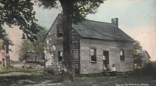
Battle hints at the location of Fur Craig’s: “James Craig lived in the house still [ie in 1910] occupied by one of his descendants in the extreme western part of the village . . . a favorite boarding house for those not adverse to long walks . . . a farm house a mile from the town.” Battle’s description would seem to place Fur Craig’s somewhere near Merritt Mill Road, nearly in what is now Carrboro.
The legal description of Alexander Piper's 1793 land donation to UNC (20 acres in what would later become downtown Carrboro) reads: “beginning at a post oak, James Craig's corner, thence West 80 poles . . .” clearly indicating that Craig’s land was just east of the Piper donation, which would place it just east of Carr Mill Mall.
UNC sold the Piper donation to James Craig's son, John M. Craig, in 1837 (Orange DB 28, pg 272). And John M. Craig sold a larger parcel in 1867 “lying on the western outskirts of Chapel Hill upon both sides of the road leading from Chapel Hill to Greensboro adjoining the lands of John Weaver, Thomas Weaver . . . beginning at the mud hole in Craigs Lane . . . to a locust on the road leading to Greensboro . . . to a rock in the road from Chapel Hill to Jones Ford on Haw River . . . containing 101 ½ acres more or less." So the property straddled Weaver Street (the road leading to Gboro) and was bounded on the south by Jones Ferry Road (the road from CH to Jones Ford). This must have constituted most of downtown Carrboro, including the Piper donation and then some.
But it is also clear that the John M. Craig tract was not “Fur Craig’s” as Battle mentions that the Craig’s still lived there in 1910, whereas John M Craig sold that tract in 1867. Also an 1879 further conveyance of the John M Craig tract to Henry H Patterson and Fendal S Hogan (ODB 46, pg 257) mentions specifically that James F. Craig owned land just to the east. Battle tells us: “James Francis Craig, his [James Craig’s] grandson, a student of the University in 1852, recently [1910] died on the old homestead.” Also, I believe James F. Craig was a member of the Chapel Hill Board of Commissioners (now Town Council) in the 1880’s, suggesting the Fur Craig’s may have been within town limits in the 1880's (ie east of Merritt Mill Road.)
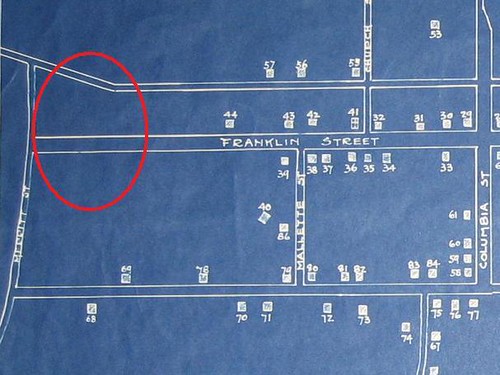
So the upshot of that would seem to be that Fur Craig’s must have been somewhere east of Merritt Mill Road, more or less in the vicinity of what is now Greenbridge. However, the Map of Chapel Hill as it was 1875-1885 shows no dwelling in that area:
Although John Craig donated only 5 acres, his family clearly owned some other land nearby. James Craig's farmhouse was known to the early students of the University as Fur Craig’s, as both Battle’s History and Hooper’s Tis Fifty Years Since tell us. It was called Fur Craig’s, as Battle says, “in distinction from the habitation of a man of the same name on the Durham road.” That is, it was not Near Craig’s; it was Fur Craig's. This picture from Steve Rankin is said to be Fur Craig's:
Battle hints at the location of Fur Craig’s: “James Craig lived in the house still [ie in 1910] occupied by one of his descendants in the extreme western part of the village . . . a favorite boarding house for those not adverse to long walks . . . a farm house a mile from the town.” Battle’s description would seem to place Fur Craig’s somewhere near Merritt Mill Road, nearly in what is now Carrboro.
The legal description of Alexander Piper's 1793 land donation to UNC (20 acres in what would later become downtown Carrboro) reads: “beginning at a post oak, James Craig's corner, thence West 80 poles . . .” clearly indicating that Craig’s land was just east of the Piper donation, which would place it just east of Carr Mill Mall.
UNC sold the Piper donation to James Craig's son, John M. Craig, in 1837 (Orange DB 28, pg 272). And John M. Craig sold a larger parcel in 1867 “lying on the western outskirts of Chapel Hill upon both sides of the road leading from Chapel Hill to Greensboro adjoining the lands of John Weaver, Thomas Weaver . . . beginning at the mud hole in Craigs Lane . . . to a locust on the road leading to Greensboro . . . to a rock in the road from Chapel Hill to Jones Ford on Haw River . . . containing 101 ½ acres more or less." So the property straddled Weaver Street (the road leading to Gboro) and was bounded on the south by Jones Ferry Road (the road from CH to Jones Ford). This must have constituted most of downtown Carrboro, including the Piper donation and then some.
But it is also clear that the John M. Craig tract was not “Fur Craig’s” as Battle mentions that the Craig’s still lived there in 1910, whereas John M Craig sold that tract in 1867. Also an 1879 further conveyance of the John M Craig tract to Henry H Patterson and Fendal S Hogan (ODB 46, pg 257) mentions specifically that James F. Craig owned land just to the east. Battle tells us: “James Francis Craig, his [James Craig’s] grandson, a student of the University in 1852, recently [1910] died on the old homestead.” Also, I believe James F. Craig was a member of the Chapel Hill Board of Commissioners (now Town Council) in the 1880’s, suggesting the Fur Craig’s may have been within town limits in the 1880's (ie east of Merritt Mill Road.)
So the upshot of that would seem to be that Fur Craig’s must have been somewhere east of Merritt Mill Road, more or less in the vicinity of what is now Greenbridge. However, the Map of Chapel Hill as it was 1875-1885 shows no dwelling in that area:
The Life of Edmund Fanning
Benson Lossing’s Pictorial Fieldbook of the Revolution includes a convenient sketch of the life of Edmund Fanning, which I thought would make a nice post on the blog. Foremost, note that Edmund Fanning is more or less no relation to the infamous Tory raider Col. David Fanning of Randolph County fame. Edmund was a notorious lawyer and loyalist who was hated by the Regulators. He was just the sort of person that John F D Stuart-Smyth was referring to when he wrote that before the Revolution some in Orange County became wealthy “by the practice of law, which in this province is peculiarly lucrative and extremely oppressive.”
Here’s Lossing’s sketch [with my comments in square brackets]:
Edmund Fanning was a native of Long Island, New York, son of Colonel Phineas Fanning. [He was Southold, Long Island per wikipedia; also the Canadian Dictionary of Biography says he was the son of James Fanning and Hannah Smith.] He was educated at Yale College, and graduated with honor in 1757. He soon afterward [1761] went to North Carolina, and began the profession of a lawyer at Hillsborough, then called Childsborough. In 1760, the degree of L.L.D. was conferred upon him by his alma mater. In 1763, he was appointed colonel of Orange county, and in 1765 was made clerk of the Superior Court at Hillsborough. He also represented Orange county in the Colonial Legislature. In common with other lawyers, he appears to have exacted exorbitant fees for legal services, and consequently incurred the dislike of the people, which was finally manifested by acts of violence. He accompanied Governor Tryon to New York, in 1771, as his secretary. Governor Martin asked the Legislature to indemnify Colonel Fanning for his losses; the representatives of the people rebuked the governor for presenting such a petition. In 1776, General Howe gave Fanning the commission of colonel, and he raised and commanded a corps called the King's American Regiment of Foot. He was afterward appointed to the lucrative office of surveyor general, which he retained until his flight, with other Loyalists, to Nova Scotia, in 1783. In 1786 he was made lieutenant governor of Nova Scotia, and in 1794 he was appointed governor of Prince Edward's Island. He held the latter office about nineteen years, a part of which time he was also a brigadier in the British army, having received his commission in 1808. He married in Nova Scotia, where some of his family yet reside. General Fanning died in London, in 1818, at the age of about eighty-one years. His widow and two daughters yet (1852) survive. One daughter, Lady Wood, a widow, resides near London with her mother; the other, wife of Captain Bentwick Cumberland, a nephew of Lord Bentwick, resides at Charlotte's Town, New Brunswick. I am indebted to John Fanning Watson, Esq., the Annalist of Philadelphia and New York, for the portrait here given.
General Fanning's early career, while in North Carolina, seems not to have given promise of that life of usefulness which he exhibited after leaving Republican America. It has been recorded, it is true, by partisan pens, yet it is said that he often expressed regrets for his indiscreet course at Hillsborough. His after life bore no reproaches, and the Gentlemen's Magazine (1818), when noting his death, remarked, "The world contained no better man in all the relations of life." [Although it should be noted that almost all 19th century obituaries have a hagiographic aspect to them.]
Wednesday, October 14, 2009
Sketch of the Life of the Rev. Dr. Alexander Wilson
Rev. Dr. Alexander Wilson's father was reportedly a wealthy man in Ireland who is said to have lost his fotune as a result of acting as a guarantor of the debts of others. It is said that the father was also named Alexander Wilson. But Rev. Alexander Wilson was called Alexander Wilson, Sr. and his son was Alexander, Jr., so it seems unlikely that the Reverend's father was also named Alexander.
In any case, the subject of this sketch was born in 1799 in County Down, Ireland, at Ballylesson. The younger Alexander Wilson grew up in Ireland, studying to become a physician. Around 1817 he graduated from Apothecaries Hall, Dublin. Wilson probably married shortly after graduation. In July 1818 he immigrated to America. Some sources say he lived for a time in New York and taught school there, but others say that North Carolina was his only state of residence in America.
Soon his wife, Mary, came to America as well and about 1820 they were in Raleigh, North Carolina. Wilson taught under Rev. William McPheeters at Raleigh Academy for a year, but then took up teaching in 1821 in Granville County at Williamsboro Academy. In 1826, Wilson was granted his United States citizenship by the Granville County Court. Wilson worked for many years in Granville County, living in Oak Hill. He was the Presbyterian minister to several congregations, including Grassy Creek Presbyterian (which moved and is now Oak Hill Presb.) and Nut Bush Presbyterian which was in the community of Williamsboro. Williamsboro is now called ___ and is in that part of old Granville County which is Vance County today. Rev. Wilson also attended the 1833 founding of Geneva Presbyterian Church in Granville County, as well as probably others.
Rev. Wilson’s work in Granville County was done under the auspices of the New Hope Presbytery. Later, Rev. Wilson became involved in the Orange Presbytery. I don’t know whether this reflects any ideological difference between these Presbyteries. The Grassy Creek Presbyterian Church history notes: “[T]he first African Americans admitted into membership of the Church was between 1833-34. In 1835 service began to be held also in a meeting house between Oak Hill and the Virginia Line, near the residence of the late Graham E. Royster.” This change occurred shortly before Wilson left the New Hope Presbytery, but it is unclear whether these events are related.
In 1833 the Orange Presbytery appointed Rev. Wilson to a committee on Presbyterian education, along with UNC Pres. David Caldwell and a number of others. The committee concluded that a Presbyterian school was needed. The Presbytery concurred and the Caldwell Institute was founded in Greensboro in 1836 with Rev. Wilson as Principal. Mary Wilson initially remained in Granville County, but probably moved to Greensboro around 1837 or 1838.
Around 1845 there was apparently an epidemic in Greensboro and so it was decided to move the school. In the summer of 1845 the Presbytery decided to move the school to Hillsborough and Rev. Wilson moved with the school. About 1850, the Caldwell Institute moved again to the vicinity of Little River Presbyterian Church northeast of Hillsborough, but Wilson did not move with it.
Rev. Wilson’s sons were James, Robert and Alexander, Jr. Robert and Alexander helped teach at their father’s school. Maj. James W. Wilson became a railroad commissioner and Robert Wilson became a businessman in Richmond, Virginia. The Wilson’s also had two daughters, one of whom died young and the other of whom, Alice E. Wilson, married Edwin A. Heartt in late 1847 (Q-H/709), the son of Hillsboro Recorder editor Dennis Heartt.
Right about the same time that Alice Wilson and Edwin Heartt were married, Rev. Wilson, his son Alexander, Jr. and Edwin Heartt bought 50 acres just north of Swepsonville in the community then known as Burnt Shop (ODB 33, pp 101-104). This site was formerly part of 300 acres conveyed from Samuel Child to John W. Norwood (deed not recorded) and was east of the land of the widow of Stephen Glass. At the same time, John A. Bingham bought an additional 50 acres, also formerly part of the Child-Norwood tract.
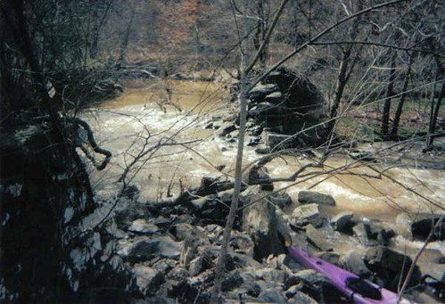
In 1851, Rev. Wilson founded his own three-room school in Burnt Shop. It is has been claimed that Henderson Scott of the Hawfields was influential in getting Wilson to choose Burnt Shop as the location for the school. If so, then those conversations must have been on-going almost from the moment that Rev. Wilson moved to Hillsborough. In any case, Wilson renamed the community after the Scotch theologian Andrew Melville. The Alexander Wilson School or Melville School became the primary fixture of Melville and earned a reputation as an excellent school. Rev. Wilson also built a gristmill on Haw Creek under the supervision of millwright Berry Davidson. However the dam was ruptured in a great flood in 1875. The remains of the dam can still be seen about 1 mile downstream of the NC 54 bridge over Haw Creek:
Rev. Wilson’s students included several members of the Morehead family, Turner Tate, Tom Roulhac, John and James Wilson, William Mebane, T. B. Bailey, John W. and Geo. Bason, L. Banks Holt, Lawrence Holt, Samuel K. Scott, J. R. Newlin, and Mayor Van Wyck, of New York. After his death in 1867, the school soon closed, but the community is still known as Melville today; and the modern public school in Melville is still called the Alexander Wilson Elementary School.
In any case, the subject of this sketch was born in 1799 in County Down, Ireland, at Ballylesson. The younger Alexander Wilson grew up in Ireland, studying to become a physician. Around 1817 he graduated from Apothecaries Hall, Dublin. Wilson probably married shortly after graduation. In July 1818 he immigrated to America. Some sources say he lived for a time in New York and taught school there, but others say that North Carolina was his only state of residence in America.
Soon his wife, Mary, came to America as well and about 1820 they were in Raleigh, North Carolina. Wilson taught under Rev. William McPheeters at Raleigh Academy for a year, but then took up teaching in 1821 in Granville County at Williamsboro Academy. In 1826, Wilson was granted his United States citizenship by the Granville County Court. Wilson worked for many years in Granville County, living in Oak Hill. He was the Presbyterian minister to several congregations, including Grassy Creek Presbyterian (which moved and is now Oak Hill Presb.) and Nut Bush Presbyterian which was in the community of Williamsboro. Williamsboro is now called ___ and is in that part of old Granville County which is Vance County today. Rev. Wilson also attended the 1833 founding of Geneva Presbyterian Church in Granville County, as well as probably others.
Rev. Wilson’s work in Granville County was done under the auspices of the New Hope Presbytery. Later, Rev. Wilson became involved in the Orange Presbytery. I don’t know whether this reflects any ideological difference between these Presbyteries. The Grassy Creek Presbyterian Church history notes: “[T]he first African Americans admitted into membership of the Church was between 1833-34. In 1835 service began to be held also in a meeting house between Oak Hill and the Virginia Line, near the residence of the late Graham E. Royster.” This change occurred shortly before Wilson left the New Hope Presbytery, but it is unclear whether these events are related.
In 1833 the Orange Presbytery appointed Rev. Wilson to a committee on Presbyterian education, along with UNC Pres. David Caldwell and a number of others. The committee concluded that a Presbyterian school was needed. The Presbytery concurred and the Caldwell Institute was founded in Greensboro in 1836 with Rev. Wilson as Principal. Mary Wilson initially remained in Granville County, but probably moved to Greensboro around 1837 or 1838.
Around 1845 there was apparently an epidemic in Greensboro and so it was decided to move the school. In the summer of 1845 the Presbytery decided to move the school to Hillsborough and Rev. Wilson moved with the school. About 1850, the Caldwell Institute moved again to the vicinity of Little River Presbyterian Church northeast of Hillsborough, but Wilson did not move with it.
Rev. Wilson’s sons were James, Robert and Alexander, Jr. Robert and Alexander helped teach at their father’s school. Maj. James W. Wilson became a railroad commissioner and Robert Wilson became a businessman in Richmond, Virginia. The Wilson’s also had two daughters, one of whom died young and the other of whom, Alice E. Wilson, married Edwin A. Heartt in late 1847 (Q-H/709), the son of Hillsboro Recorder editor Dennis Heartt.
Right about the same time that Alice Wilson and Edwin Heartt were married, Rev. Wilson, his son Alexander, Jr. and Edwin Heartt bought 50 acres just north of Swepsonville in the community then known as Burnt Shop (ODB 33, pp 101-104). This site was formerly part of 300 acres conveyed from Samuel Child to John W. Norwood (deed not recorded) and was east of the land of the widow of Stephen Glass. At the same time, John A. Bingham bought an additional 50 acres, also formerly part of the Child-Norwood tract.
In 1851, Rev. Wilson founded his own three-room school in Burnt Shop. It is has been claimed that Henderson Scott of the Hawfields was influential in getting Wilson to choose Burnt Shop as the location for the school. If so, then those conversations must have been on-going almost from the moment that Rev. Wilson moved to Hillsborough. In any case, Wilson renamed the community after the Scotch theologian Andrew Melville. The Alexander Wilson School or Melville School became the primary fixture of Melville and earned a reputation as an excellent school. Rev. Wilson also built a gristmill on Haw Creek under the supervision of millwright Berry Davidson. However the dam was ruptured in a great flood in 1875. The remains of the dam can still be seen about 1 mile downstream of the NC 54 bridge over Haw Creek:
Rev. Wilson’s students included several members of the Morehead family, Turner Tate, Tom Roulhac, John and James Wilson, William Mebane, T. B. Bailey, John W. and Geo. Bason, L. Banks Holt, Lawrence Holt, Samuel K. Scott, J. R. Newlin, and Mayor Van Wyck, of New York. After his death in 1867, the school soon closed, but the community is still known as Melville today; and the modern public school in Melville is still called the Alexander Wilson Elementary School.
Monday, October 12, 2009
Lossing’s Pictorial Field Book of the Revolution
Continuing with my series of blog posts on travelers’ descriptions of their journeys between Hillsborough and Salisbury, North Carolina, I present Benson J. Lossing’s Pictorial Field Book of the Revolution. Lossing traveled all over the east coast visiting and researching important (and not so important) Revolutionary War sites and most of the book is about the history of the Revolutionary War. His account of Greene and Cornwallis’s Race to the Dan is a classic on the topic and is wonderfully detailed, but weaved into that narrative is Lossing’s own narrative about Lossing’s trip from Hillsborough to Salisbury in 1849. Lossing’s penchant for story-telling is delightful. In reproducing his story I have mostly edited out the Revolutionary tales. Those parts of his book are also well worth reading, but they distract from the 1849 narrative.
My comments are in [square brackets]. The more interesting footnotes from Lossing’s book are included here in (parentheses). Enjoy:
I employed the first morning of the new year (1849), in visiting places of interest at Hillsborough, in company with the Reverend Dr. Wilson. [This must have been Alexander Wilson, the schoolmaster of the Caldwell Institute in Hillsborough and later the founder of the Wilson School in Melville, near Swepsonville, NC.] The first object to which my attention was called was a small wooden building, represented in the engraving on the next page, situated opposite the hotel where I was lodged. Cornwallis used it for an office, during his tarryings in Hillsborough, after driving General Greene out of the state. After sketching this, we visited the office of the Clerk of Superior Court, and made the fac similes and extracts from its records, printed on pages 573-4. We next visited the headquarters of Cornwallis, a large frame building situated in the rear of Morris’s Hillsborough House, on King Street. Generals Gates and Greene also occupied it when they were in Hillsborough, and there a large number of the members of the Provincial Congress were generally lodged. The old court-house, where the Regulators performed their lawless acts, is no longer in existence. I was informed by Major Taylor, an octogenarian on whom we called, that it was a brick edifice, and stood almost upon the exact site of the present court-house, which is a spacious brick building, with steeple and clock. The successor of the first was a wooden structure, and being removed to make room for the present building, was converted into a place of meeting for a society of Baptists, who yet worship there. Upon the hill near the Episcopal church, and fronting King Street, is the spot where the Regulators were hung. The residence of Governor Tryon, while in Hillsborough, was on Church Street, a little west of Masonic Hall. These compose the chief objects of historic interest at Hillsborough. The town has other associations connected with the Southern campaigns, but we will not anticipate the revealments of history by considering them now.
At one o’clock I exchanged adieus with the kind Dr. Wilson, crossed the Eno, and , pursuing the route traversed by Tryon on his march to the Allamance, crossed the rapid and now turbid Haw, just below the falls, at sunset [apparently at Swepsonville]. I think I never traveled a worse road than the one stretching between the Eno and the Haw. It passes over a continued series of red clay hills, which are heavily wooded with oaks, gums, black locusts, and chestnuts. Small streams course among these elevations; and in summer this region must be exceedingly picturesque. Now every tree and shrub was leafless, except the holly and the laurel, and nothing green appeared among the wide reaching branches but the beautiful tufts of mistletoe which every where decked the great oaks with their delicate leaves and transparent berries. Two and a half miles beyond the Haw, and eighteen from Hillsborough, I passed the night at Foust’s house of entertainment, and after an early breakfast, rode to the place where Colonel Pyle, a Tory officer, with a considerable body of Loyalists, was deceived and defeated by Lieutenant-colonel Henry Lee and his dragoons, with Colonel Pickens, in the spring of 1781. Dr. Holt, who lives a short distance from that locality, kindly accompanied me to the spot and pointed out the place where the battle occurred; where Colonel Pyle lay concealed in a pond, and where many of the slain were buried. (About a quarter of a mile northwest from this pond, is the spot where the battle occurred. It was then heavily wooded; now it is a cleared field, on the plantation of Colonel Michael Holt. Mr. Holt planted an apple tree upon the spot where fourteen of the slain were buried in one grave. Near by, a persimmon-tree indicates the place of burial of several others. [This footnote is to a part of the text that I omitted, but the note is interesting and relates also to this part of the text, so I included it here.])The place of conflict is about half a mile north of the old Salisbury highway, upon a “plantation road,” two miles east of the Allamance, in Orange county. Let us listen to the voices of history and tradition.
[Here Lossing gives a long and detailed account of Pyle’s Massacre, which I am omitting.]
I left the place of Pyle’s defeat toward noon, and, following a sinuous and seldom traveled road through a forest of wild crab-apple trees and black jacks, crossed the Allamance at the cotton factory of Holt and Carrigan, two miles distant [the village of Alamance]. (This factory, in the midst of a cotton-growing country, and upon a never-failing stream, can not be otherwise than source of great profit to the owners. The machinery is chiefly employed in the manufacture of cotton yarn. Thirteen hundred and fifty spindles were in operation. Twelve loons were employed in the manufacture of coarse cotton goods suitable for the use of the Negroes. [Slaves wore clothes made from a cheap, coarse fabric called osnaburg. The Holt's made mostly osnaburg and a much finer plaid.]) Around this mill quite a village of neat log-houses occupied by the operatives, were collected, and every thing had the appearance of thrift. I went in, and was pleased to see the hands of intelligent white females employed in a useful occupation. Manual labor by white people is a rare sight at the South, where an abundance of slave labor appears to render such occupation unnecessary; and it can seldom be said of one of our fair sisters there, “She layeth her hands to the spindle, and her hands hold the distaff.” This cotton mill, like the few others which I saw in the Carolinas, is a real blessing, present and prospective, for it gives employment and comfort to many poor girls who might otherwise be wretched; and it is a seed of industry planted in a generous soil, which may hereafter germinate and bear abundant fruit of its kind in the midst of cotton plantations, thereby augmenting immensely the true wealth of the nation. [Boy, was he right about that. In 1849, the only other cotton mills in the Haw watershed were at Big Falls (Hopedale) and Saxpahaw. By 1881, there were 12 and by 1900 there were dozens.]
At a distance of two miles and a half beyond the Allamance, on the Salisbury road [more or less NC 62], , I reached the Regulator battle-ground; and, in company with a young man residing in the vicinity, visited the points of particular interest, and a made the sketch printed on page 577. The rock and the ravine from whence James Pugh and his companions (see page 576) did such execution with their rifles, are now hardly visible. The place is a few rods north of the road. The ravine is almost filled by the washing down of earth from the slopes during eighty years; and the rock projects only a few ells above the surface. The whole of the natural scenery is changed, and nothing but tradition can identify the spot. [Almost makes me think that he did not find the right place.]
While viewing the battle-ground, the wind, which had been a gentle and pleasant breeze from the south all the morning, veered to the northeast, and brought omens of a cold storm. I left the borders of the Allamance, and it associations, at one o’clock, and traversing a very hilly country for eighteen miles, arrived, a little after dark, at Greensborough, a thriving, compact village, situated about five miles southeast from the site of old Guilford Court House. It is the capitol of Guilford county, and successor of old Martinsburg, where the court-house was formerly situated. Very few of the villages in the interior of the state appeared to me more like a Northern town than Greensborough. The houses are generally good, and the stores gave evidence of active trade. Within an hour after my arrival, the town was thrown into commotion by the bursting out of flames from a large frame dwelling, a short distance from the court-house. There being no fire-engine in the places, the flames spread rapidly, and at one time menaced the safety of the whole town. A small keg of powder was used, without effect, to demolish a tailor’s shop, standing in the path of the conflagration toward a large tavern. The flames passed on, until confronted by one of those broad chimneys, on the outside of the house, so universally prevalent at the South, when it was subdued, after four buildings were destroyed. I never saw a population more thoroughly frightened; and when I returned to my lodgings, far away from the fire, every bed in the house was packed ready for flight. It was past midnight when the town became quiet, and a consequently late breakfast delayed my departure for the battle-field at Guilford Court House, until nine o’clock the next morning. [It would be interesting to compare this with contemporary press accounts of this fire.]
A cloudy sky, a biting north wind, and the dropping of a few snow-flakes when I left Greensborough, betokened an unpleasant day for my researches. It was ten o’clock when I reached Martinsville, once a pleasant hamlet, now a desolation. There are only a few dilapidated and deserted dwellings left; and nothing remains of the old Guilford Court House but the ruins of a chimney depicted on the plan of the battle, printed on page 608. Only one house was inhabited, and that by the tiller of the soil around it. Descending into a narrow broken valley, from Martinsville, and ascending the opposite slope to still higher ground on the road to Salem, I passed among the fields consecrated by the events of the battle at Guilford, in March, 1781 to the house of Mr. Hotchkiss, a Quaker, who, I was informed could point out every locality of interest in his neighborhood.
Mr. Hotchkiss was absent, and I was obliged to wait more than an hour for his return. The time passed pleasantly in conversation with his daughter, an intelligent young lady, who kindly ordered my horse to be fed, and regaled me with some fine apples, the first fruit of the kind I had seen since leaving the James River. While tarrying there, the snow began to fall thickly, and when, about noon, I rambled over the most interesting portion of the battle-ground, and sketched the scene printed on page 611, the whole country was covered with a white mantle. Here, by this hospitable fireside, let us consider the battle, and those wonderful antecedents events which distinguished General Green’s celebrated Retreat.
[Lossing describes the Race to the Dan and the Battle of Guilford Courthouse in great detail, a wonderful account that I am omitting here.]
I left the Guilford battle-ground and the hospitable cottage of Mr. Hotchkiss, at noon, the snow falling fast. At four miles distant, on the Salisbury road, I reached the venerable New Garden meeting-house, yet standing within the stately oak forest where Lee and Tarleton met. It is a frame building with a brick foundation. It was meeting-day, and the congregation were yet in session. Tying Charley [his horse] to a drooping branch, I entered softly. A larger number than is usually present at “week-day meetings” had congregated, for a young man of the sect from Randolph county, thirty miles distant, and a young woman of Guilford, had signified their intentions to declare themselves publicly on that day, man and wife. [I think it would be straight forward to identify who this couple was.] They had just risen before the elders and people when I glided into a seat near the door, and with a trembling voice the bridegroom had begun the expression of the marriage vow. His weather-bronzed features betokened the man of toil in the fields, and strongly contrasted with the blonde and delicate face, and slender form of her who, with the downcast eyes of modesty, heard his pledge of love and protection, and was summoning all her energy to make her kindred response. I had often observed the simple marriage ceremony of the Quakers, but never before did the beauty of that ritual appear so marked with the sublimity of pure simplicity.
At the close of the meeting, I learned from one of the elders that a Friend’s boarding-school was near, and, led by curiosity, I visited it. [What school is this?] The building is of brick, spacious, and well arranged. It was under the superintendence of Thomas Hunt, a son of Nathan Hunt, an eminent Quaker preacher. An incidental remark concerning my relationship with Quakers, made while conversing with the wife of the superintendent, caused her to inquire whether I had ever heard of here father-in-law. I replied in the affirmative, having heard him preach when I was a boy, and expressed the supposition that he had long ago gone to his rest. “Oh no,” she replied, “he is in the adjoining room,: and leading the way, I was introduced to the patriarch of ninety-one years. He remembered well when the New Garden meetinghouse was built, and resided in the neighborhood when the wounded and dying, from the field of Guilford, were brought there. Although physical infirmities were weighing heavily upon him, his mind appeared clear and elastic. When I was about departing, and pressed his hand with an adieu, he placed the other upon my head and said, “Farewell! God’s peace go with thee!” I felt as if I had received the blessing of a patriarch indeed; and for days afterward, when fording dangerous streams and traversing rough mountain roads, that uttered blessing was in my mind, and seemed like a guardian angel about my path. Gloomy unbelief may deride, and thoughtless levity may laugh in ridicule at such an intimation, but all the philosophy of schools could not give me such exquisite feelings of security in the hands of a kind Providence as that old man’s blessing imparted.
The storm yet continued, and the kind matron of the school gave me a cordial invitation to remain there until it should cease; but, anxious to complete my journey, I rode on to Jamestown, an old village situated upon the high southwestern bank of the Deep River, nine miles from New Garden meeting-house, and thirteen miles above Bell’s Mills, where Cornwallis had his encampment before the Guilford battle. The country through which I had passed from Guilford was very broken, and I did not reach Jamestown until sunset. It is chiefly inhabited by Quakers, the most of them originally from Nantucket and vicinity; and as they do not own slaves, nor employ slave labor, except when a servant is working to purchase his freedom, the land and the dwellings presented an aspect of thrift not visible in most of the agricultural districts in the upper country of the Carolinas.
I passed the night at Jamestown, and early in the morning departed for the Yadkin. Snow was yet falling gently, and it laid three inches deep upon the ground; a greater quantity than had fallen at one time, in that section, for five years. Fortunately my route from thence to Lexington, in Davidson county, a distance of twenty miles, was upon a fine ridge road a greater portion of the way, and the snow produced but little inconvenience. (These ridge roads, or rather ridges upon which they are constructed, are curious features in the upper country of the Carolinas. Although the whole country is hilly upon every side, these roads may be traveled a score of miles, sometimes, with hardly ten feet of variation from a continuous level. The ridges are of sand, and continue, unbroken by ravines, which cleave the hills in all directions for miles, upon almost a uniform level. The roads following their summits are exceedingly sinuous, but being level and hard, the greater distance is more easily accomplished than if they were constructed in straight lines over the hills. The country has the appearance of vast waves of the sea suddenly turned into sand.)
Toward noon, the clouds broke, and before I reached Lexington (a small village on the west side of Abbott’s Creek, a tributary of the Yadkin), at half past two in the afternoon, not a flake of snow remained. Charley and I had already lunched by the margin of a little stream, so I drove through the village without halting, hoping to reach Salisbury, sixteen miles distant, by twilight. I was disappointed; for the red clay roads prevailed, and I only reached the house of a small planted within a mile of the east bank of the Yadkin, just as the twilight gave place to the splendors of a full moon and myriads of stars in a cloudless sky. From the proprietor I learned that the Trading Ford, where Greene and Morgan crossed when pursued by Cornwallis, was only a mile distant. As I could not pass it on my way to Salisbury in the morning, I arose at four o’clock, gave Charley his breakfast and at earliest dawn stood upon the eastern shore of the Yadkin, and made the sketch printed upon page 601. The air was frosty, the pools were bridged with ice, and before the sketch was finished, my benumbed fingers were disposed to drop the pencil. I remained at the ford until the east was all aglow with the radiance of the rising sun, when I walked back, partook of some corn-bread, muddy coffee, and spare-ribs, and at eight o’clock crossed the Yadkin at the great bridge, on the Salisbury road. The river is there about three hundred yards wide, and was considerably swollen from the melting of the recent snows. Its volume of turbid waters came rolling down in a swift current, and gave me a full appreciation of the barrier which Providence had there placed between the Republicans and the royal armies, when engaged in the great race described in this chapter.
From the Yadkin the roads passed through a red clay region, which was made so miry by the melting snows that it was almost eleven o’clock when I arrived at Salisbury. This village, of over a thousand inhabitants, is situated a few miles from the Yadkin, and is the capital of Rowan county, a portion of the “Hornet’s Nest” of the Revolution. It is a place of considerable historic note. On account of its geographical position, it was often the place of rendezvous of the militia preparing for the battle-fields; of various regular corps, American and British, during the last tree years of the war; and especially as the brief resting-place of both armies during Greene’s memorable retreat. Here, too, it will be remembered, General Waddell had his head-quartes for a few days during the “Regulator war.” I made a diligent inquiry during my tarry in Salisbury, for remains of Revolutionary movements and localities, but could hear of none. The Americans when fleeing before Cornwallis, encamped for a night about half a mile from the village, on the road to the Yadkin; the British occupied a position on the northern border of the town, about an eighth of a mile from the court-house. I was informed that two buildings occupied by officers, had remained until two or three years ago when they were demolished. Finding nothing to invite a protracted stay at Salisbury, I resumed the reins, and rode on toward Concord. The roads were very bad, and the sun went down, while a rough way, eight miles in extent, lay between me and Concord.
Sunday, October 11, 2009
Lawson Crosses Proto-Orange County
Following is the part of John Lawson’s famous New Voyage to Carolina (1710). Lawson’s account is a classic and I have little to add to it. This part of the book describes Lawson’s journey from Salisbury, NC to Hillsborough, NC along the Native Trading Path and the parts in [brackets] are my comments or interpretations about his description. Douglass Rights wrote the seminal interpretation of Lawson’s journey in the early 20th century and many of my comments are based on Rights’ interpretation.
Monday.
On Monday Morning, our whole Company, with the Horses, set out from the Sapona-Indian Town [Salisbury], after having seen some of the Locust, which is gotten thereabouts, the same Sort that bears Honey. Going over several Creeks, very convenient for Water-Mills, about 8 Miles from the Town, we pass'd over a very pretty River, call'd Rocky River, a fit Name, having a Ridge of high Mountains running from its Banks, to the Eastward; and disgorging itself into Sapona-River [the Yadkin]; so that there is a most pleasant and convenient Neck of Land, betwixt both Rivers, lying upon a Point, where many thousand Acres may be fenced in, without much Cost or Labour. You can scarce go a Mile, without meeting with one of these small swift Currents, here being no Swamps to be found, but pleasant, dry Roads all over the Country. The Way that we went this day, was as full of Stones, as any which Craven, in the West of Yorkshire, could afford, and having nothing but Moggisons [moccasins] on my Feet, I was so lam'd by this stony Way, that I thought I must have taken up some Stay in those Parts. We went, this day, not above 15 or 20 Miles. After we had supp'd, and all lay down to sleep, there came a Wolf close to the Fire-side, where we lay. My Spaniel soon discover'd him, at which, one of our Company fir'd a Gun at the Beast; but, I believe, there was a Mistake in the loading of it, for it did him no Harm. The Wolf stay'd till he had almost loaded again, but the Bitch making a great Noise, at last left us and went aside. We had no sooner laid down, but he approach'd us again, yet was more shy, so that we could not get a Shot at him.
Tuesday.
Next day, we had 15 Miles farther to the Keyauwees. The Land is more mountainous, but extremely pleasant, and an excellent Place for the breeding Sheep, Goats, and Horses; or Mules, if the English were once brought to the Experience of the Usefulness of those Creatures. The Valleys are here very rich. At Noon, we pass'd over such another stony River, as that eight Miles from Sapona. This is call'd Heighwaree [the Uwharrie], and affords as good blue Stone for Mill-Stones, as that from Cologn, good Rags, some Hones, and large Pebbles, in great abundance, besides Free-Stone of several Sorts, all very useful. I knew one of these Hones made use of by an Acquaintance of mine, and it prov'd rather better than any from Old Spain, or elsewhere. The Veins of Marble are very large and curious on this River, and the Banks thereof.
Five Miles from this River, to the N. W. stands the Keyauwees Town. [Rights suggests that Lawson meant NE not NW; the town was therefore in the Caraway Mountains north of Randleman.] They are fortify'd in, with wooden Puncheons, like Sapona, being a People much of the same Number. Nature hath so fortify'd this Town, with Mountains, that were it a Seat of War, it might easily be made impregnable; having large Corn-Fields joining to their Cabins, and a Savanna near the Town, at the Foot of these Mountains, that is capable of keeping some hundred Heads of Cattle. And all this environ'd round with very high Mountains, so that no hard Wind ever troubles these Inhabitants. Those high Clifts have no Grass growing on them, and very few Trees, which are very short, and stand at a great Distance one from another. The Earth is of a red Colour, and seems to me to be wholly design'd by Nature for the 'Production of Minerals, being of too hot a Quality, to suffer any Verdure upon its Surface. These Indians make use of Lead-Ore, to paint their Faces withal, which they get in the neighbouring Mountains. As for the refining of Metals, the Indians are wholly ignorant of it, being content with the Realgar. But if it be my Chance, once more to visit these Hilly Parts, I shall make a longer Stay amongst them: For were a good Vein of Lead found out, and work'd by an ingenious Hand, it might be of no small Advantage to the Undertaker, there being great Convenience for smelting, either by Bellows or Reverberation; and the Working of these Mines might discover some that are much richer.
At the Top of one of these Mountains, is a Cave that 100 Men may fit very conveniently to dine in; whether natural, or artificial, I could not learn. [No one has ever explained this claim.] There is a fine Bole between this Place, and the Saps. These Valleys thus hemm'd in with Mountains, would (doubtless) prove a good place for propagating some sort of Fruits, that our Easterly Winds commonly blast. The Vine could not miss of thriving well here; but we of the Northern Climate are neither Artists, nor curious, in propagating that pleasant and Vegetable. Near the Town, is such another Current, as Heighwaree. We being six in Company, divided ourselves into Two Parties; and it was my Lot to be at the House of Keyauwees Jack, who is King of that People. He is a Congeree-Indian, and ran away when he was a Boy. He got this Government by Marriage with the Queen; the Female Issue carrying the Heritage, for fear of Impostors; the Savages well knowing, how much Frailty possesses the Indian Women, betwixt the Garters and the Girdle. [Lawson is withal racist - although less so than some of the English - but this comment is so offensive that I have to call him out for it.]
Wednesday.
The next day, having some occasion to write, the Indian King, who saw me, believ'd that he could write as well as I. Whereupon, I wrote a Word, and gave it him to copy, which he did with more Exactness, than any European could have done, that was illiterate. It was so well, that he who could read mine, might have done the same by his. Afterwards, he took great Delight in making Fish-hooks of his own Invention, which would have been a good Piece for an Antiquary to have puzzled his Brains withal, in tracing out the Characters of all the Oriental Tongues. He sent for several Indians to his Cabin, to look at his Handy-work, and both he and they thought, I could read his Writing as well as I could my own. I had a Manual in my Pocket, that had King David's Picture in it, in one of his private Retirements. The Indian ask'd me, Who that Figure represented? I told him, It was the Picture of a good King, that liv'd according to the Rules of Morality, doing to all as he would be done by, ordering all his Life to the Service of the Creator of all things; and being now above us all, in Heaven, with God Almighty, who had rewarded him with all the delightful Pleasures imaginable in the other World, for his Obedience to him in this; I concluded, with telling them, that we received nothing here below, as Food, Raiment, &c. but what came from that Omnipotent Being. They listned to my Discourse with a profound Silence, assuring me, that they believ'd what I said to be true. No Man living will ever be able to make these Heathens sensible of the Happiness of a future State, except he now and then mentions some lively carnal Representation, which may quicken their Apprehensions, and make them thirst after such a gainful Exchange; for, were the best Lecture that ever was preach'd by Man, given to an ignorant sort of People, in a more learned Style, than their mean Capacities are able to understand, the Intent would prove ineffectual, and the Hearers would be left in a greater Labyrinth than their Teacher found them in. But dispense the Precepts of our Faith according to the Pupil's Capacity, and there is nothing in our Religion, but what an indifferent Reason is, in some measure, able to comprehend; tho' a New-England Minister blames the French Jesuits for this way of Proceeding, as being quite contrary to a true Christian Practice, and affirms it to be no ready, or true Method, to establish a lively Representation of our Christian Belief amongst these Infidels.
All the Indians hereabouts carefully preserve the Bones of the Flesh they eat, and burn them, as being of Opinion, that if they omitted that Custom, the Game would leave their Country, and they should not be able to maintain themselves by their Hunting. Most of these Indians wear Mustachoes, or Whiskers, which is rare; by reason the Indians are a People that commonly pull the Hair of their Faces, and other Parts, up by the Roots, and suffer none to grow. Here is plenty of Chesnuts [we see few of them today owing to the Chestnut Blight], which are rarely found in Carolina, and never near the Sea, or Salt-Water; tho' they are frequently in such Places in Virginia.
At the other House, where our Fellow-Travellers lay, they had provided a Dish, in great Fashion amongst the Indians, which was Two young Fawns, taken out of the Doe's Bellies, and boil'd in the same slimy Bags Nature had plac'd them in, and one of the Country-Hares, stew'd with the Guts in her Belly, and her Skin with the Hair on. This new-fashion'd Cookery wrought Abstinence in our Fellow-Travellers, which I somewhat wonder'd at, because one of them made nothing of eating Allegators, as heartily as if it had been Pork and Turneps. The Indians dress most things after the Wood-cock Fashion, never taking the Guts out. At the House we lay at, there was very good Entertainment of Venison, Turkies, and Bears; and which is customary amongst the Indians, the Queen had a Daughter by a former Husband, who was the beautifullest Indian I ever saw, and had an Air of Majesty with her, quite contrary to the general Carriage of the Indians. She was very kind to the English, during our Abode, as well as her Father and Mother.
Thursday.
This Morning, most of our Company having some Inclination to go straight away for Virginia, when they left this Place; I and one more took our leaves of them, resolving (with God's Leave) to see North-Carolina, one of the Indians setting us in our way. The rest being indifferent which way they went, desired us, by all means, to leave a Letter for them, at the Achonechy-Town [Hillsborough]. The Indian that put us in our Path, had been a Prisoner amongst the Sinnagers; but had out-run them, although they had cut his Toes, and half his Feet away, which is a Practice common amongst them. They first raise the Skin, then cut away half the Feet, and so wrap the Skin over the Stumps, and make a present Cure of the Wounds. This commonly disables them from making their Escape, they being not so good Travellers as before, and the Impression of their Half-Feet making it easy to trace them. However, this Fellow was got clear of them, but had little Heart to go far from home, and carry'd always a Case of Pistols in his Girdle, besides a Cutlass, and a Fuzee. Leaving the rest of our Company at the Indian-Town, we travell'd, that day, about 20 Miles, in very cold, frosty Weather; and pass'd over two pretty Rivers, something bigger than Heighwaree, but not quite so stony. We took these two Rivers to make one of the Northward Branches of Cape-Fair River, but afterwards found our Mistake.
Friday.
The next day, we travell'd over very good Land, but full of Free-Stone, and Marble, which pinch'd our Feet severely. [Presumably by marble lawson means large chunks of quartz which are common in some areas of the Piedmont.] We took up our Quarters in a sort of Savanna-Ground, that had very few Trees in it. The Land was good, and had several Quarries of Stone, but not loose, as the others us'd to be.
Saturday.
Next Morning, we got our Breakfasts of Parch'd Corn, having nothing but that to subsist on for above 100 Miles. All the Pine-Trees were vanish'd, for we had seen none for two days. [Other authorities seem to agree that Pine trees were not nearly so common in Orange County 250 years ago.] We pass'd through a delicate rich Soil this day; no great Hills, but pretty Risings, and Levels, which made a beautiful Country. We likewise pass'd over three Rivers this day; the first about the bigness of Rocky River, the other not much differing in Size. Then we made not the least Question, but we had pass'd over the North-West Branch of Cape-Fair [Cape Fear], travelling that day above 30 Miles. We were much taken with the Fertility and Pleasantness of the Neck of Land between these two Branches, and no less pleas'd, that we had pass'd the River, which us'd to frighten Passengers from fording it. At last, determining to rest on the other side of a Hill, which we saw before us; when we were on the Top thereof, there appear'd to us such another delicious, rapid Stream, as that of Sapona, having large Stones, about the bigness of an ordinary House, lying up and down the River. [Authorities agree that this was somewhere near Swepsonville – perhaps in what is now that village or perhaps a few miles north.] As the Wind blew very cold at N. W. and we were very weary, and hungry, the Swiftness of the Current gave us some cause to fear; but, at last, we concluded to venture over that Night. Accordingly, we stripp'd, and with great Difficulty, (by God's Assistance) got safe to the North-side of the famous Hau-River [Haw River], by some called Reatkin; the Indians differing in the Names of Place, according to their several Nations. It is call'd Hau-River, from the Sissipahau Indians, who dwell upon this Stream, which is one of the main Branches of Cape-Fair, there being rich Land enough to contain some Thousands of Families [the Haw Old Fields or Hawfields]; for which Reason, I hope, in a short time, it will be planted. This River is much such another as Sapona; both seeming to run a vast way up the Country. Here is plenty of good Timber, and especially, of a Scaly-bark'd Oak [White Oak]; And as there is Stone enough in both Rivers, and the Land is extraordinary Rich, no Man that will be content within the Bounds of Reason, can have any grounds to dislike it. And they that are otherwise, are the best Neighbours, when farthest off. [Amen.]
Sunday.
As soon as it was day, we set out for the Achonechy- Town [Hillsborough], it being, by Estimation, 20 Miles off, which, I believe, is pretty exact. We were got about half way, (meeting great Gangs of Turkies) when we saw, at a Distance, 30 loaded Horses, coming on the Road, with four or five Men, on other Jades, driving them. We charg'd our Piece, and went up to them: Enquiring, whence they came from? They told us, from Virginia. The leading Man's Name was Massey, who was born about Leeds in Yorkshire. He ask'd, from whence we came? We told him. Then he ask'd again, Whether we wanted any thing that he had? telling us, we should be welcome to it. We accepted of Two Wheaten Biskets, and a little Ammunition. He advised us, by all means, to strike down the Country for Ronoack, and not think of Virginia, because of the Sinnagers, of whom they were afraid, tho' so well arm'd, and numerous. They persuaded us also, to call upon one Enoe Will, as we went to Adshusheer, for that he would conduct us safe among the English, giving him the Character of a very faithful Indian, which we afterwards found true by Experience. The Virginia-Men asking our Opinion of the Country we were then in? we told them, it was a very pleasant one. [This was the Haw Old Fields.] They were all of the same Opinion, and affirm'd, That they had never seen 20 Miles of such extraordinary rich Land, lying all together, like that betwixt Hau-River and the Achonechy Town. Having taken our Leaves of each other, we set forward; and the Country, thro' which we pass'd, was so delightful, that it gave us a great deal of Satisfaction. About Three a Clock, we reach'd the Town, and the Indians presently brought us good fat Bear, and Venison, which was very acceptable at that time. Their Cabins were hung with a good sort of Tapestry, as fat Bear, and barbakued or dried Venison; no Indians having greater Plenty of Provisions than these. The Savages do, indeed, still possess the Flower of Carolina, the English enjoying only the Fag-end of that fine Country. We had not been in the Town 2 Hours, when Enoe-Will came into the King's Cabin; which was our Quarters. We ask'd him, if he would conduct us to the English, and what he would have for his Pains; he answer'd, he would go along with us, and for what he was to have, he left that to our Discretion.
Monday.
The next Morning, we set out, with Enoe-Will, towards Adshusheer [a village NE of Durham], leaving the Virginia Path [the Native Trading Path], and striking more to the Eastward [probably along the Fish Dam Road – more or less Old NC 10], for Ronoack. Several Indians were in our Company belonging to Will's Nation, who are the Shoccories, mixt with the Enoe-Indians, and those of the Nation of Adshusheer. Enoe-Will is their chief Man, and rules as far as the Banks of Reatkin [the Haw]. It was a sad stony Way to Adshusheer. We went over a small River by Achonechy, and in this 14 Miles, through several other Streams, which empty themselves into the Branches of Cape-Fair. The stony Way made me quite lame; so that I was an Hour or two behind the rest; but honest Will would not leave me, but bid me welcome when we came to his House, feasting us with hot Bread, and Bears-Oil; which is wholsome Food for Travellers. There runs a pretty Rivulet by this Town. Near the Plantation, I saw a prodigious overgrown Pine-Tree, having not seen any of that Sort of Timber for above 125 Miles: They brought us 2 Cocks, and pull'd their larger Feathers off, never plucking the lesser, but singeing them off. I took one of these Fowls in my Hand, to make it cleaner than the Indian had, pulling out his Guts and Liver, which I laid in a Bason; notwithstanding which, he kept such a Struggling for a considerable time, that I had much ado to hold him in my Hands. The Indians laugh'd at me, and told me, that Enoe-Will had taken a Cock of an Indian that was not at home, and the Fowl was design'd for another Use. I conjectur'd, that he was design'd for an Offering to their God, who, they say, hurts them, (which is the Devil.) In this Struggling, he bled afresh, and there issued out of his Body more Blood than commonly such Creatures afford. Notwithstanding all this, we cook'd him, and eat him; and if he was design'd for him, cheated the Devil. The Indians keep many Cocks, but seldom above one Hen, using very often such wicked Sacrifices, as I mistrusted this Fowl was design'd for.
Our Guide and Landlord Enoe-Will was of the best and most agreeable Temper that ever I met with in an Indian, being always ready to serve the English, not out of Gain, but real Affection; which makes him apprehensive of being poison'd by some wicked Indians, and was therefore very earnest with me, to promise him to revenge his Death, if it should so happen. He brought some of his chief Men into his Cabin, and 2 of them having a Drum, and a Rattle, sung by us, as we lay in Bed, and struck up their Musick to serenade and welcome us to their Town. And tho' at last, we fell asleep, yet they continu'd their Consort till Morning. These Indians are fortify'd in, as the former, and are much addicted to a Sport they call Chenco, which is carry'd on with a Staff and a Bowl made of Stone, which they trundle upon a smooth Place, like a Bowling-Green, made for that Purpose, as I have mention'd before.
Tuesday.
Next Morning, we set out, with our Guide, and several other Indians, who intended to go to the English, and buy Rum. We design'd for a Nation about 40 Miles from Adshusheer, call'd the Lower Quarter: The first Night, we lay in a rich Perkoson, or low Ground, that was hard-by a Creek, and good dry Land.
Wednesday.
The next day, we went over several Tracts of rich Land, but mix'd with Pines and other indifferent Soil. In our way, there stood a great Stone about the Size of a large Oven, and hollow; this the Indians took great Notice of, putting some Tobacco into the Concavity, and spitting after it. I ask'd them the reason of their so doing, but they made me no Answer. In the Evening, we pass'd over a pleasant Rivulet, with a fine gravelly Bottom, having come over such another that Morning. On the other side of this River, we found the Indian Town, which was a Parcel of nasty smoaky Holes, much like the Waterrees; their Town having a great Swamp running directly through the Middle thereof. The Land here begins to abate of its Height, and has some few Swamps. Most of these Indians have but one Eye; but what Mischance or Quarrel has bereav'd them of the other I could not learn. They were not so free to us, as most of the other Indians had been; Victuals being somewhat scarce among them. However, we got enough to satisfy our Appetites. I saw, among these Men, very long Arrows, headed with Pieces of Glass, which they had broken from Bottles. They had shap'd them neatly, like the Head of a Dart; but which way they did it, I can't tell. We had not been at this Town above an Hour, when two of our Company, that had bought a Mare of John Stewart, came up to us, having receiv'd a Letter by one of Will's Indians, who was very cautious, and asked a great many Questions, to certifie him of the Person, e'er he would deliver the Letter. They had left the Trader, and one that came from South-Carolina with us, to go to Virginia; these Two being resolved to go to Carolina with us.
Thursday.
This Day fell much Rain, so we staid at the Indian Town.
Friday.
This Morning, we set out early, being four English-Men, besides several Indians. We went 10 Miles, and were then stopp'd by the Freshes of Enoe-River, which had rais'd it so high, that we could not pass over, till it was fallen, I enquir'd of my Guide, Where this River disgorg'd it self? He said, It was Enoe-River, and run into a Place call'd Enoe-Bay, near his Country, which he left when he was a Boy; by which I perceiv'd,he was one of the Cores by Birth: This being a Branch of Neus-River.
Saturday.
This Day, our Fellow-Traveller's Mare ran away from him; wherefore, Will went back as far as the lower Quarter, and brought her back.
Sunday.
The next Day, early, came two Tuskeraro Indians to the other side of the River, but could not get over. They talk'd much to us, but we understood them not. In the Afternoon, Will came with the Mare, and had some Discourse with them; they told him, The English, to whom he was going, were very wicked People; and, That they threatned the Indians for Hunting near their Plantations. These Two Fellows were going among the Schoccores and Achonechy Indians, to sell their Wooden Bowls and Ladles for Raw-Skins, which they make great Advantage of, hating that any of these Westward Indians should have any Commerce with the English, which would prove a Hinderance to their Gains. Their Stories deterr'd an Old Indian and his Son, from going any farther; but Will told, us, Nothing they had said should frighten him, he believing them to be a couple of Hog-s[t]ealers; and that the English only sought Restitution of their Losses, by them; and that this was the only ground for their Report. Will had a Slave, a Sissipahau-Indian by Nation, who killed us several Turkies, and other Game, on which we feasted.
Monday.
This River is near as large as Reatkin; the South-side having curious Tracts of good Land, the Banks high, and Stone-Quarries. The Tuskeruros being come to us, we ventur'd over the River, which we found to be a strong Current, and the Water about Breast-high. However, we all got safe to the North-Shore, which is but poor, white, sandy Land, and bears no Timber, but small shrubby Oaks. We went about 10 Miles, and sat down at the Falls of a large Creek, where lay mighty Rocks, the Water making a strange Noise, as if a great many Water-Mills were going at once. I take this to be the Falls of Neus-Creek, called by the Indians, Wee quo Whom [Falls of Neuse]. We lay here all Night. My Guide Will desiring to see the Book that I had about me, I lent it him; and as he soon found the Picture of King David, he asked me several Questions concerning the Book, and Picture, which I resolv'd him, and invited him to become a Christian. He made me a very sharp Reply, assuring me, That he lov'd the English extraordinary well, and did believe their Ways to be very good for those that had already practs'd them, and had been brought up therein; But as for himself, he was too much in Years to think of a Change, esteeming it not proper for Old People to admit of such an Alteration. However, he told me, If I would take his Son Jack, who was then about 14 Years of Age, and teach him to talk in that Book, and make Paper speak, which they call our Way of Writing, he would wholly resign him to my Tuition; telling me, he was of Opinion, I was very well affected to the Indians.
Tuesday.
The next Morning, we set out early, and I perceiv'd that these Indians were in some fear of Enemies; for they had an Old Man with them, who was very cunning and circumspect, wheresoever he saw any Marks of Footing, or of any Fire that had been made; going out of his Way, very often, to look for these Marks. We went, this day, above 30 Miles, over a very level Country, and most Pine Land, yet intermix'd with some Quantities of Marble; a good Range for Cattel, though very indifferent for Swine. We had now lost our rapid Streams, and were come to slow, dead Waters, of a brown Colour, proceeding from the Swamps, much like the Sluices in Holland, where the Track-Scoots go along. In the Afternoon, we met two Tuskeruros, who told us, That there was a Company of Hunters not far of, and if we walk'd stoutly, we might reach them that Night. But Will and He that own'd the Mare, being gone before, and the Old Indian tired, we rested, that Night, in the Woods, making a good light Fire, Wood being very plentiful in these Parts.
Monday.
On Monday Morning, our whole Company, with the Horses, set out from the Sapona-Indian Town [Salisbury], after having seen some of the Locust, which is gotten thereabouts, the same Sort that bears Honey. Going over several Creeks, very convenient for Water-Mills, about 8 Miles from the Town, we pass'd over a very pretty River, call'd Rocky River, a fit Name, having a Ridge of high Mountains running from its Banks, to the Eastward; and disgorging itself into Sapona-River [the Yadkin]; so that there is a most pleasant and convenient Neck of Land, betwixt both Rivers, lying upon a Point, where many thousand Acres may be fenced in, without much Cost or Labour. You can scarce go a Mile, without meeting with one of these small swift Currents, here being no Swamps to be found, but pleasant, dry Roads all over the Country. The Way that we went this day, was as full of Stones, as any which Craven, in the West of Yorkshire, could afford, and having nothing but Moggisons [moccasins] on my Feet, I was so lam'd by this stony Way, that I thought I must have taken up some Stay in those Parts. We went, this day, not above 15 or 20 Miles. After we had supp'd, and all lay down to sleep, there came a Wolf close to the Fire-side, where we lay. My Spaniel soon discover'd him, at which, one of our Company fir'd a Gun at the Beast; but, I believe, there was a Mistake in the loading of it, for it did him no Harm. The Wolf stay'd till he had almost loaded again, but the Bitch making a great Noise, at last left us and went aside. We had no sooner laid down, but he approach'd us again, yet was more shy, so that we could not get a Shot at him.
Tuesday.
Next day, we had 15 Miles farther to the Keyauwees. The Land is more mountainous, but extremely pleasant, and an excellent Place for the breeding Sheep, Goats, and Horses; or Mules, if the English were once brought to the Experience of the Usefulness of those Creatures. The Valleys are here very rich. At Noon, we pass'd over such another stony River, as that eight Miles from Sapona. This is call'd Heighwaree [the Uwharrie], and affords as good blue Stone for Mill-Stones, as that from Cologn, good Rags, some Hones, and large Pebbles, in great abundance, besides Free-Stone of several Sorts, all very useful. I knew one of these Hones made use of by an Acquaintance of mine, and it prov'd rather better than any from Old Spain, or elsewhere. The Veins of Marble are very large and curious on this River, and the Banks thereof.
Five Miles from this River, to the N. W. stands the Keyauwees Town. [Rights suggests that Lawson meant NE not NW; the town was therefore in the Caraway Mountains north of Randleman.] They are fortify'd in, with wooden Puncheons, like Sapona, being a People much of the same Number. Nature hath so fortify'd this Town, with Mountains, that were it a Seat of War, it might easily be made impregnable; having large Corn-Fields joining to their Cabins, and a Savanna near the Town, at the Foot of these Mountains, that is capable of keeping some hundred Heads of Cattle. And all this environ'd round with very high Mountains, so that no hard Wind ever troubles these Inhabitants. Those high Clifts have no Grass growing on them, and very few Trees, which are very short, and stand at a great Distance one from another. The Earth is of a red Colour, and seems to me to be wholly design'd by Nature for the 'Production of Minerals, being of too hot a Quality, to suffer any Verdure upon its Surface. These Indians make use of Lead-Ore, to paint their Faces withal, which they get in the neighbouring Mountains. As for the refining of Metals, the Indians are wholly ignorant of it, being content with the Realgar. But if it be my Chance, once more to visit these Hilly Parts, I shall make a longer Stay amongst them: For were a good Vein of Lead found out, and work'd by an ingenious Hand, it might be of no small Advantage to the Undertaker, there being great Convenience for smelting, either by Bellows or Reverberation; and the Working of these Mines might discover some that are much richer.
At the Top of one of these Mountains, is a Cave that 100 Men may fit very conveniently to dine in; whether natural, or artificial, I could not learn. [No one has ever explained this claim.] There is a fine Bole between this Place, and the Saps. These Valleys thus hemm'd in with Mountains, would (doubtless) prove a good place for propagating some sort of Fruits, that our Easterly Winds commonly blast. The Vine could not miss of thriving well here; but we of the Northern Climate are neither Artists, nor curious, in propagating that pleasant and Vegetable. Near the Town, is such another Current, as Heighwaree. We being six in Company, divided ourselves into Two Parties; and it was my Lot to be at the House of Keyauwees Jack, who is King of that People. He is a Congeree-Indian, and ran away when he was a Boy. He got this Government by Marriage with the Queen; the Female Issue carrying the Heritage, for fear of Impostors; the Savages well knowing, how much Frailty possesses the Indian Women, betwixt the Garters and the Girdle. [Lawson is withal racist - although less so than some of the English - but this comment is so offensive that I have to call him out for it.]
Wednesday.
The next day, having some occasion to write, the Indian King, who saw me, believ'd that he could write as well as I. Whereupon, I wrote a Word, and gave it him to copy, which he did with more Exactness, than any European could have done, that was illiterate. It was so well, that he who could read mine, might have done the same by his. Afterwards, he took great Delight in making Fish-hooks of his own Invention, which would have been a good Piece for an Antiquary to have puzzled his Brains withal, in tracing out the Characters of all the Oriental Tongues. He sent for several Indians to his Cabin, to look at his Handy-work, and both he and they thought, I could read his Writing as well as I could my own. I had a Manual in my Pocket, that had King David's Picture in it, in one of his private Retirements. The Indian ask'd me, Who that Figure represented? I told him, It was the Picture of a good King, that liv'd according to the Rules of Morality, doing to all as he would be done by, ordering all his Life to the Service of the Creator of all things; and being now above us all, in Heaven, with God Almighty, who had rewarded him with all the delightful Pleasures imaginable in the other World, for his Obedience to him in this; I concluded, with telling them, that we received nothing here below, as Food, Raiment, &c. but what came from that Omnipotent Being. They listned to my Discourse with a profound Silence, assuring me, that they believ'd what I said to be true. No Man living will ever be able to make these Heathens sensible of the Happiness of a future State, except he now and then mentions some lively carnal Representation, which may quicken their Apprehensions, and make them thirst after such a gainful Exchange; for, were the best Lecture that ever was preach'd by Man, given to an ignorant sort of People, in a more learned Style, than their mean Capacities are able to understand, the Intent would prove ineffectual, and the Hearers would be left in a greater Labyrinth than their Teacher found them in. But dispense the Precepts of our Faith according to the Pupil's Capacity, and there is nothing in our Religion, but what an indifferent Reason is, in some measure, able to comprehend; tho' a New-England Minister blames the French Jesuits for this way of Proceeding, as being quite contrary to a true Christian Practice, and affirms it to be no ready, or true Method, to establish a lively Representation of our Christian Belief amongst these Infidels.
All the Indians hereabouts carefully preserve the Bones of the Flesh they eat, and burn them, as being of Opinion, that if they omitted that Custom, the Game would leave their Country, and they should not be able to maintain themselves by their Hunting. Most of these Indians wear Mustachoes, or Whiskers, which is rare; by reason the Indians are a People that commonly pull the Hair of their Faces, and other Parts, up by the Roots, and suffer none to grow. Here is plenty of Chesnuts [we see few of them today owing to the Chestnut Blight], which are rarely found in Carolina, and never near the Sea, or Salt-Water; tho' they are frequently in such Places in Virginia.
At the other House, where our Fellow-Travellers lay, they had provided a Dish, in great Fashion amongst the Indians, which was Two young Fawns, taken out of the Doe's Bellies, and boil'd in the same slimy Bags Nature had plac'd them in, and one of the Country-Hares, stew'd with the Guts in her Belly, and her Skin with the Hair on. This new-fashion'd Cookery wrought Abstinence in our Fellow-Travellers, which I somewhat wonder'd at, because one of them made nothing of eating Allegators, as heartily as if it had been Pork and Turneps. The Indians dress most things after the Wood-cock Fashion, never taking the Guts out. At the House we lay at, there was very good Entertainment of Venison, Turkies, and Bears; and which is customary amongst the Indians, the Queen had a Daughter by a former Husband, who was the beautifullest Indian I ever saw, and had an Air of Majesty with her, quite contrary to the general Carriage of the Indians. She was very kind to the English, during our Abode, as well as her Father and Mother.
Thursday.
This Morning, most of our Company having some Inclination to go straight away for Virginia, when they left this Place; I and one more took our leaves of them, resolving (with God's Leave) to see North-Carolina, one of the Indians setting us in our way. The rest being indifferent which way they went, desired us, by all means, to leave a Letter for them, at the Achonechy-Town [Hillsborough]. The Indian that put us in our Path, had been a Prisoner amongst the Sinnagers; but had out-run them, although they had cut his Toes, and half his Feet away, which is a Practice common amongst them. They first raise the Skin, then cut away half the Feet, and so wrap the Skin over the Stumps, and make a present Cure of the Wounds. This commonly disables them from making their Escape, they being not so good Travellers as before, and the Impression of their Half-Feet making it easy to trace them. However, this Fellow was got clear of them, but had little Heart to go far from home, and carry'd always a Case of Pistols in his Girdle, besides a Cutlass, and a Fuzee. Leaving the rest of our Company at the Indian-Town, we travell'd, that day, about 20 Miles, in very cold, frosty Weather; and pass'd over two pretty Rivers, something bigger than Heighwaree, but not quite so stony. We took these two Rivers to make one of the Northward Branches of Cape-Fair River, but afterwards found our Mistake.
Friday.
The next day, we travell'd over very good Land, but full of Free-Stone, and Marble, which pinch'd our Feet severely. [Presumably by marble lawson means large chunks of quartz which are common in some areas of the Piedmont.] We took up our Quarters in a sort of Savanna-Ground, that had very few Trees in it. The Land was good, and had several Quarries of Stone, but not loose, as the others us'd to be.
Saturday.
Next Morning, we got our Breakfasts of Parch'd Corn, having nothing but that to subsist on for above 100 Miles. All the Pine-Trees were vanish'd, for we had seen none for two days. [Other authorities seem to agree that Pine trees were not nearly so common in Orange County 250 years ago.] We pass'd through a delicate rich Soil this day; no great Hills, but pretty Risings, and Levels, which made a beautiful Country. We likewise pass'd over three Rivers this day; the first about the bigness of Rocky River, the other not much differing in Size. Then we made not the least Question, but we had pass'd over the North-West Branch of Cape-Fair [Cape Fear], travelling that day above 30 Miles. We were much taken with the Fertility and Pleasantness of the Neck of Land between these two Branches, and no less pleas'd, that we had pass'd the River, which us'd to frighten Passengers from fording it. At last, determining to rest on the other side of a Hill, which we saw before us; when we were on the Top thereof, there appear'd to us such another delicious, rapid Stream, as that of Sapona, having large Stones, about the bigness of an ordinary House, lying up and down the River. [Authorities agree that this was somewhere near Swepsonville – perhaps in what is now that village or perhaps a few miles north.] As the Wind blew very cold at N. W. and we were very weary, and hungry, the Swiftness of the Current gave us some cause to fear; but, at last, we concluded to venture over that Night. Accordingly, we stripp'd, and with great Difficulty, (by God's Assistance) got safe to the North-side of the famous Hau-River [Haw River], by some called Reatkin; the Indians differing in the Names of Place, according to their several Nations. It is call'd Hau-River, from the Sissipahau Indians, who dwell upon this Stream, which is one of the main Branches of Cape-Fair, there being rich Land enough to contain some Thousands of Families [the Haw Old Fields or Hawfields]; for which Reason, I hope, in a short time, it will be planted. This River is much such another as Sapona; both seeming to run a vast way up the Country. Here is plenty of good Timber, and especially, of a Scaly-bark'd Oak [White Oak]; And as there is Stone enough in both Rivers, and the Land is extraordinary Rich, no Man that will be content within the Bounds of Reason, can have any grounds to dislike it. And they that are otherwise, are the best Neighbours, when farthest off. [Amen.]
Sunday.
As soon as it was day, we set out for the Achonechy- Town [Hillsborough], it being, by Estimation, 20 Miles off, which, I believe, is pretty exact. We were got about half way, (meeting great Gangs of Turkies) when we saw, at a Distance, 30 loaded Horses, coming on the Road, with four or five Men, on other Jades, driving them. We charg'd our Piece, and went up to them: Enquiring, whence they came from? They told us, from Virginia. The leading Man's Name was Massey, who was born about Leeds in Yorkshire. He ask'd, from whence we came? We told him. Then he ask'd again, Whether we wanted any thing that he had? telling us, we should be welcome to it. We accepted of Two Wheaten Biskets, and a little Ammunition. He advised us, by all means, to strike down the Country for Ronoack, and not think of Virginia, because of the Sinnagers, of whom they were afraid, tho' so well arm'd, and numerous. They persuaded us also, to call upon one Enoe Will, as we went to Adshusheer, for that he would conduct us safe among the English, giving him the Character of a very faithful Indian, which we afterwards found true by Experience. The Virginia-Men asking our Opinion of the Country we were then in? we told them, it was a very pleasant one. [This was the Haw Old Fields.] They were all of the same Opinion, and affirm'd, That they had never seen 20 Miles of such extraordinary rich Land, lying all together, like that betwixt Hau-River and the Achonechy Town. Having taken our Leaves of each other, we set forward; and the Country, thro' which we pass'd, was so delightful, that it gave us a great deal of Satisfaction. About Three a Clock, we reach'd the Town, and the Indians presently brought us good fat Bear, and Venison, which was very acceptable at that time. Their Cabins were hung with a good sort of Tapestry, as fat Bear, and barbakued or dried Venison; no Indians having greater Plenty of Provisions than these. The Savages do, indeed, still possess the Flower of Carolina, the English enjoying only the Fag-end of that fine Country. We had not been in the Town 2 Hours, when Enoe-Will came into the King's Cabin; which was our Quarters. We ask'd him, if he would conduct us to the English, and what he would have for his Pains; he answer'd, he would go along with us, and for what he was to have, he left that to our Discretion.
Monday.
The next Morning, we set out, with Enoe-Will, towards Adshusheer [a village NE of Durham], leaving the Virginia Path [the Native Trading Path], and striking more to the Eastward [probably along the Fish Dam Road – more or less Old NC 10], for Ronoack. Several Indians were in our Company belonging to Will's Nation, who are the Shoccories, mixt with the Enoe-Indians, and those of the Nation of Adshusheer. Enoe-Will is their chief Man, and rules as far as the Banks of Reatkin [the Haw]. It was a sad stony Way to Adshusheer. We went over a small River by Achonechy, and in this 14 Miles, through several other Streams, which empty themselves into the Branches of Cape-Fair. The stony Way made me quite lame; so that I was an Hour or two behind the rest; but honest Will would not leave me, but bid me welcome when we came to his House, feasting us with hot Bread, and Bears-Oil; which is wholsome Food for Travellers. There runs a pretty Rivulet by this Town. Near the Plantation, I saw a prodigious overgrown Pine-Tree, having not seen any of that Sort of Timber for above 125 Miles: They brought us 2 Cocks, and pull'd their larger Feathers off, never plucking the lesser, but singeing them off. I took one of these Fowls in my Hand, to make it cleaner than the Indian had, pulling out his Guts and Liver, which I laid in a Bason; notwithstanding which, he kept such a Struggling for a considerable time, that I had much ado to hold him in my Hands. The Indians laugh'd at me, and told me, that Enoe-Will had taken a Cock of an Indian that was not at home, and the Fowl was design'd for another Use. I conjectur'd, that he was design'd for an Offering to their God, who, they say, hurts them, (which is the Devil.) In this Struggling, he bled afresh, and there issued out of his Body more Blood than commonly such Creatures afford. Notwithstanding all this, we cook'd him, and eat him; and if he was design'd for him, cheated the Devil. The Indians keep many Cocks, but seldom above one Hen, using very often such wicked Sacrifices, as I mistrusted this Fowl was design'd for.
Our Guide and Landlord Enoe-Will was of the best and most agreeable Temper that ever I met with in an Indian, being always ready to serve the English, not out of Gain, but real Affection; which makes him apprehensive of being poison'd by some wicked Indians, and was therefore very earnest with me, to promise him to revenge his Death, if it should so happen. He brought some of his chief Men into his Cabin, and 2 of them having a Drum, and a Rattle, sung by us, as we lay in Bed, and struck up their Musick to serenade and welcome us to their Town. And tho' at last, we fell asleep, yet they continu'd their Consort till Morning. These Indians are fortify'd in, as the former, and are much addicted to a Sport they call Chenco, which is carry'd on with a Staff and a Bowl made of Stone, which they trundle upon a smooth Place, like a Bowling-Green, made for that Purpose, as I have mention'd before.
Tuesday.
Next Morning, we set out, with our Guide, and several other Indians, who intended to go to the English, and buy Rum. We design'd for a Nation about 40 Miles from Adshusheer, call'd the Lower Quarter: The first Night, we lay in a rich Perkoson, or low Ground, that was hard-by a Creek, and good dry Land.
Wednesday.
The next day, we went over several Tracts of rich Land, but mix'd with Pines and other indifferent Soil. In our way, there stood a great Stone about the Size of a large Oven, and hollow; this the Indians took great Notice of, putting some Tobacco into the Concavity, and spitting after it. I ask'd them the reason of their so doing, but they made me no Answer. In the Evening, we pass'd over a pleasant Rivulet, with a fine gravelly Bottom, having come over such another that Morning. On the other side of this River, we found the Indian Town, which was a Parcel of nasty smoaky Holes, much like the Waterrees; their Town having a great Swamp running directly through the Middle thereof. The Land here begins to abate of its Height, and has some few Swamps. Most of these Indians have but one Eye; but what Mischance or Quarrel has bereav'd them of the other I could not learn. They were not so free to us, as most of the other Indians had been; Victuals being somewhat scarce among them. However, we got enough to satisfy our Appetites. I saw, among these Men, very long Arrows, headed with Pieces of Glass, which they had broken from Bottles. They had shap'd them neatly, like the Head of a Dart; but which way they did it, I can't tell. We had not been at this Town above an Hour, when two of our Company, that had bought a Mare of John Stewart, came up to us, having receiv'd a Letter by one of Will's Indians, who was very cautious, and asked a great many Questions, to certifie him of the Person, e'er he would deliver the Letter. They had left the Trader, and one that came from South-Carolina with us, to go to Virginia; these Two being resolved to go to Carolina with us.
Thursday.
This Day fell much Rain, so we staid at the Indian Town.
Friday.
This Morning, we set out early, being four English-Men, besides several Indians. We went 10 Miles, and were then stopp'd by the Freshes of Enoe-River, which had rais'd it so high, that we could not pass over, till it was fallen, I enquir'd of my Guide, Where this River disgorg'd it self? He said, It was Enoe-River, and run into a Place call'd Enoe-Bay, near his Country, which he left when he was a Boy; by which I perceiv'd,he was one of the Cores by Birth: This being a Branch of Neus-River.
Saturday.
This Day, our Fellow-Traveller's Mare ran away from him; wherefore, Will went back as far as the lower Quarter, and brought her back.
Sunday.
The next Day, early, came two Tuskeraro Indians to the other side of the River, but could not get over. They talk'd much to us, but we understood them not. In the Afternoon, Will came with the Mare, and had some Discourse with them; they told him, The English, to whom he was going, were very wicked People; and, That they threatned the Indians for Hunting near their Plantations. These Two Fellows were going among the Schoccores and Achonechy Indians, to sell their Wooden Bowls and Ladles for Raw-Skins, which they make great Advantage of, hating that any of these Westward Indians should have any Commerce with the English, which would prove a Hinderance to their Gains. Their Stories deterr'd an Old Indian and his Son, from going any farther; but Will told, us, Nothing they had said should frighten him, he believing them to be a couple of Hog-s[t]ealers; and that the English only sought Restitution of their Losses, by them; and that this was the only ground for their Report. Will had a Slave, a Sissipahau-Indian by Nation, who killed us several Turkies, and other Game, on which we feasted.
Monday.
This River is near as large as Reatkin; the South-side having curious Tracts of good Land, the Banks high, and Stone-Quarries. The Tuskeruros being come to us, we ventur'd over the River, which we found to be a strong Current, and the Water about Breast-high. However, we all got safe to the North-Shore, which is but poor, white, sandy Land, and bears no Timber, but small shrubby Oaks. We went about 10 Miles, and sat down at the Falls of a large Creek, where lay mighty Rocks, the Water making a strange Noise, as if a great many Water-Mills were going at once. I take this to be the Falls of Neus-Creek, called by the Indians, Wee quo Whom [Falls of Neuse]. We lay here all Night. My Guide Will desiring to see the Book that I had about me, I lent it him; and as he soon found the Picture of King David, he asked me several Questions concerning the Book, and Picture, which I resolv'd him, and invited him to become a Christian. He made me a very sharp Reply, assuring me, That he lov'd the English extraordinary well, and did believe their Ways to be very good for those that had already practs'd them, and had been brought up therein; But as for himself, he was too much in Years to think of a Change, esteeming it not proper for Old People to admit of such an Alteration. However, he told me, If I would take his Son Jack, who was then about 14 Years of Age, and teach him to talk in that Book, and make Paper speak, which they call our Way of Writing, he would wholly resign him to my Tuition; telling me, he was of Opinion, I was very well affected to the Indians.
Tuesday.
The next Morning, we set out early, and I perceiv'd that these Indians were in some fear of Enemies; for they had an Old Man with them, who was very cunning and circumspect, wheresoever he saw any Marks of Footing, or of any Fire that had been made; going out of his Way, very often, to look for these Marks. We went, this day, above 30 Miles, over a very level Country, and most Pine Land, yet intermix'd with some Quantities of Marble; a good Range for Cattel, though very indifferent for Swine. We had now lost our rapid Streams, and were come to slow, dead Waters, of a brown Colour, proceeding from the Swamps, much like the Sluices in Holland, where the Track-Scoots go along. In the Afternoon, we met two Tuskeruros, who told us, That there was a Company of Hunters not far of, and if we walk'd stoutly, we might reach them that Night. But Will and He that own'd the Mare, being gone before, and the Old Indian tired, we rested, that Night, in the Woods, making a good light Fire, Wood being very plentiful in these Parts.
Thursday, October 8, 2009
Housing Segregation in Chapel Hill
Housing segregation in Chapel Hill, NC was a strongly established tradition for most of the 20th Century, but it was not always that way. In the 19th Century, racial residential patterns in Chapel Hill were much different.
The Map of Chapel Hill as it was in 1875-1885 (H. D. Carter, 1934) shows a number of houses that are identified as African-American households. I thought it would be intersting to compare the distribution of those households with the early to mid 20th century housing segregation line.
In 1944, Charles Freeman made a map as a part of his Masters Thesis showing housing segregation in Chapel Hill:
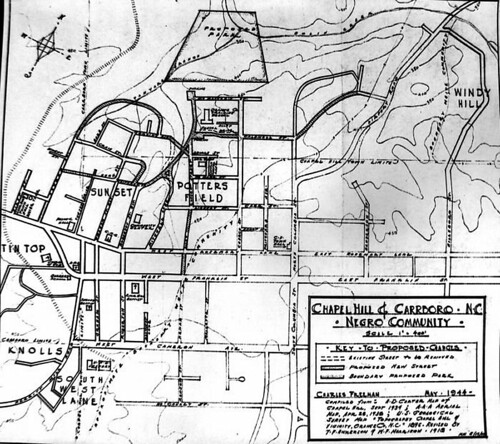
Having lived in the Northside neighborhood in Chapel Hill, I can say that Freeman's color segregation line was largely still the case into the 1990's.
So I copied over onto H. D. Carter's map that segregation line in yellow and then circled the 1875-1885 African American households:
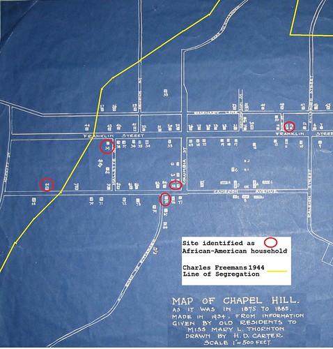
And the result is striking. Only one of the 1875-1885 African American households was in an area that was a segregated black neighborhood. All the rest were in areas that were white-only neighborhoods in the 20th century.
This pattern is consistent with the findings of professional historians and geographers - that segregation was something that was imposed in the South in the period 1890-1900, not immediately after the Civil War. I believe research has been done on Charleston, SC illustrating this.
While Chapel Hill never had any sort of housing segregation ordinances (de jure), there was a strong de facto tradition. As well, when we look at the restrictive covenants of neighborhoods in and near Chapel Hill, we can see that developers imposed their own Whites-only covenants in some neighborhoods such as Greenwood and Dogwood Acres. Those developments happened in the 1930's and 1940's, though. Prior to that time, it appears that housing segregation was purely a matter of tradition - enforced by the men who ran the local real estate market, rather than the formal power of the government.
The Map of Chapel Hill as it was in 1875-1885 (H. D. Carter, 1934) shows a number of houses that are identified as African-American households. I thought it would be intersting to compare the distribution of those households with the early to mid 20th century housing segregation line.
In 1944, Charles Freeman made a map as a part of his Masters Thesis showing housing segregation in Chapel Hill:
Having lived in the Northside neighborhood in Chapel Hill, I can say that Freeman's color segregation line was largely still the case into the 1990's.
So I copied over onto H. D. Carter's map that segregation line in yellow and then circled the 1875-1885 African American households:
And the result is striking. Only one of the 1875-1885 African American households was in an area that was a segregated black neighborhood. All the rest were in areas that were white-only neighborhoods in the 20th century.
This pattern is consistent with the findings of professional historians and geographers - that segregation was something that was imposed in the South in the period 1890-1900, not immediately after the Civil War. I believe research has been done on Charleston, SC illustrating this.
While Chapel Hill never had any sort of housing segregation ordinances (de jure), there was a strong de facto tradition. As well, when we look at the restrictive covenants of neighborhoods in and near Chapel Hill, we can see that developers imposed their own Whites-only covenants in some neighborhoods such as Greenwood and Dogwood Acres. Those developments happened in the 1930's and 1940's, though. Prior to that time, it appears that housing segregation was purely a matter of tradition - enforced by the men who ran the local real estate market, rather than the formal power of the government.
History for Sale
Orange County government is strapped for cash and will be selling four pieces of surplus real estate around the county. Among the properties to be sold is the Alexander Graham Building at 118 North Churton Street in Hillsborough.
This remarkable and beautiful building is made of mortared stone in the Greek Revival style. It is only one story tall with a columned porch that makes the building look a bit like a miniature bank or courthouse.
The building’s cornerstone says “Graham Building 1930” and a little sleuthing shows that this was originally built as a private law office for Alexander H. Graham. Graham was at one time Lieutenant Governor of North Carolina and lived in Hillsborough at Montrose.
I don’t know why Lt. Gov. Graham chose to build such a solid and beautiful law office, but he did. By any standards this building is an inspired little piece of architecture and the method of construction appears to have been of uncompromising quality. Graham went for quality, not only in the finished surfaces, which are still beautiful and intact 80 years later, but in structural soundness. The building looks and feels like it will still be in downtown Hillsborough 80 years from now.
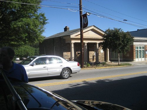
The minimum bid has been set at $130,000, and although the building is only about 700 square feet, I feel pretty confident that the County will get considerably more than that for it. I hope whoever buys this building will treat it like a treasure, because that is what it is.
This remarkable and beautiful building is made of mortared stone in the Greek Revival style. It is only one story tall with a columned porch that makes the building look a bit like a miniature bank or courthouse.
The building’s cornerstone says “Graham Building 1930” and a little sleuthing shows that this was originally built as a private law office for Alexander H. Graham. Graham was at one time Lieutenant Governor of North Carolina and lived in Hillsborough at Montrose.
I don’t know why Lt. Gov. Graham chose to build such a solid and beautiful law office, but he did. By any standards this building is an inspired little piece of architecture and the method of construction appears to have been of uncompromising quality. Graham went for quality, not only in the finished surfaces, which are still beautiful and intact 80 years later, but in structural soundness. The building looks and feels like it will still be in downtown Hillsborough 80 years from now.
The minimum bid has been set at $130,000, and although the building is only about 700 square feet, I feel pretty confident that the County will get considerably more than that for it. I hope whoever buys this building will treat it like a treasure, because that is what it is.
Saturday, October 3, 2009
Ch. 20 of Suart-Smyth's A Tour in the United States (1784)
CHAP. XX
Newse-River. Hillsborough. Stong Post. Haw
Fields. Singular Phenomena. Accounted for.
The last two considerable streams of water that I crossed on my way to this place, Fishing-creek and Tar-river, receiving several inferior creeks and branches in their course, form a tolerable large river, which passing by Tarburg, falls into the immense body of water, that is known by the appellation of Pamplico sound, at the Bath town, after a course of about an hundred and fifty miles, in a direct line, from the source.
It was in February when I left this place, and again proceeded on my journey.
At the end of two miles, I crossed Flat river, and in two miles farther, Little river; these, with another river (the Eno) within a couple of miles more, meet some small distance below, and form the river Newse.
Each of these small rivers, is larger than the Thames at Richmond, and the Newse is not much inferior to the Roanoak.
After a course of more than three hundred miles, it empties itself in Pamplico sound, about thirty miles below the town of Newbern, which is sometimes called and lately established as the capital of North-Carolina.
This town is situated in a very beautiful spot, on the banks of the Newse, at the confluence of a pretty stream, named Trent river.
After a ride of twenty-two miles, I arrived at Hillsborough, where I dined and passed the rest of the day.
This is the third appellation this town has already been honoured with since it was erected, being first named Corben town, next Childsburg, now Hillsborough; all in less than thirty years.
It is also the capital of a district, and the county-town of Orange.
Hillsborough is a healthy spot, enjoys a good share of commerce for an inland town, and is in a very promising state of improvement.
The land for some distance around Hillsborough, consists of a mixture of loam and strong red clay of so bright a colour that white horses and cattle, soon after they are brought there, become in appearance a fine scarlet. [I suppose this is true in a way, but really, scarlet?]
In the vicinity of Hillsborough, and to the westward of it, there are a great many very fine farms, and a number of excellent mills.
The inhabitants are chiefly natives of Ireland and Germany, but of the very lowest and most ignorant class, who export large quantities of exceeding good butter and flour, in wagons, to Halifax, Petersburg, &c. besides multitudes of fat cattle, beeves [beefs], and hogs.
There is a very steep and high hill, or small mountain, with two summits of an equal height, on the south-west of Hillsborough, which arises abruptly in the middle of an extensive plain, and commands the whole country for a great distance around.
This might easily be rendered a very strong post, by works thrown up on the summits, which are near enough to cover and support each other, and so situated, as the communication between them could not be interrupted. The flanks and rear likewise would be strengthened by the river Eno, which runs at the base of this mountain, and two sides of it. [Such an unusual perspective on Occaneechee Mountain. Says a lot about the author and his times.]
The staple produce of all this country being provisions of every kind, a fortified post in this place would thereby be enabled to subsist and maintain itself in every necessary supply, excepting arms and ammunition, and might be defended, by a small force, against a very considerable and superior army.
Almost every man in this country has been the fabricator of his own fortune, and many of them are very opulent.
Some have obtained their riches by commerce, others by the practice of law, which in this province is peculiarly lucrative and extremely oppressive; but most of them have acquired their possessions by cropping, farming, and industry. [Pretty much what the War of the Regulation was all about.]
I dined next day, by invitation, at the house of Mr. Frank Nash.
{Since then it has happened, in the vicissitudes of fortune, that Mr. Nash and the author were engaged in battle on different sides; Mr. Nash as a General in the American army, and the author a Captain in the British, at the action of German-Town, near Philadelphia, where Mr. Nash received his mortal wound.}
Here, at Mr. Nash’s, I happened to meet a Mr. Mabin [Alexander Mebane presumably] (a native of Ireland) who very kindly insisted on my accompanying him to his seat on Haw river, adjoining the Haw fields, to spend some weeks there.
Having a great desire to view the Haw fields, a place I had heard much about, I went along with him to his plantation, which is about an easy day’s ride, west of Hillsborough.
Mr. Mabin’s farm is very valuable and extensive, but not particularly remarkable. [Mr. Smyth Stuart is not a terribly gracious guest.]
I rode several times over the Haw fields, but could not perceive any thing in them extraordinary. [You know, John Lawson said of this area: "the Land is extraordinary Rich, no Man that will be content within the Bounds of Reason, can have any grounds to dislike it. And they that are otherwise, are the best Neighbours, when farthest of[f]." So I guess we know who Lawson was talking about.]
They consist partly of wide savannahs, or glades, and partly of large fields overgrown with shrubs, brush, and low under-wood, entirely destitute of heavy timber. But there appears many vestiges of trees, which in all probability have been blown down by a hurricane, and the young shoots afterwards choaked by the extreme thickness of the low bushes, and scrubby underwood. This I have also observed to be the case in many other places besides. [Sounds doubtful.]
From the effect of these most violent and tremendous hurricanes and tornadoes, which being sometimes partial, frequently move in strange and fantastic directions, and from the irresistible force of the wind, and the vast deluges and inundations of water that generally accompany them, all the appearances may be readily
[It seems as though the typographer omitted a portion of the text here. There is a page break before the next word and I think maybe an entire page was erroneously omitted.]
accounted for in a common natural way, which, however, have lately given scope to an ingenious, celebrated and elegant author’s (Dr. Dunbar) and others of less note (Mr. Carver,&c.) vague imaginations; hazarding their fanciful and wild conjectures of some of these being vestiges of military works erected many ages past by a people then conversant in the science, but whose descendants, by the mere dint of practice, (for war and hunting appear from the most early period of time to have been the sole study and occupation of their lives,) and by some other equally absurd and unaccountable transitions, have thereby forgotten, and, at this day, have lost every trace thereof.
Indeed it must be confessed, that the elephant’s bones, or those of some other unknown animal of vast magnitude, found on the banks of the river Ohio, the antique sculptures in the Delaware’s country, on the north-west side of that amazing river, the shells and marine substances in the Alegany mountains, together with many other strange appearances and singular phenomena, so frequently to be met with throughout this most extensive continent, display a fertile field for a creative, fanciful genius to explore, and may give rise to the most novl, elegant, and beautiful flights of imaginstion, and the brightest, most ingenious and splendid embellishments of fiction. [He sure has a way of wandering pretty far afield.]
However, I have reason to believe, that some of the Haw fields have been cleared of woods by the Indians, in ages past, who were undoubtedly settled here; many insignia, and vestiges of the remains of their towns, still remaning. [So generous. All authorities certainly agree the that Haw old fields are far older than the European settlers.]
Chapter 21 of Smyth-Stuart's A Tour in the United States (1784)
CHAP. XXI.
Haw river. Deep river. Cape Fear river. Carroway mountains. Grand and elegant Perspective. Bad Accomodations. Unsuitable to an Epicure, or a Petit Maitre.
Having it in speculation to visit Henderson’s settlement on Kentucky, I mentioned my intention to Mr. Mabin [Mebane], who appeared very strenuous in dissuading me from undertaking such an enterprise at present, on account of the misunderstanding and disturbances now subsisting between the Indians and the Whites.
He informed me of a report, that even Henderson’s whole settlement was either exterminated, or in imminent danger of being so.
For this reason, I concluded to postpone this arduous undertaking, until such time as more certain and favourable intelligence of their situation in the settlement should arrive, and a better prospect of reaching it without molestation.
On the third evening after I came here, a gentleman, named Frohawk [Thomas Frohawk, the Clerk of Court in Salisbury?], called at Mr. Mabin’s, on his return to Salisbury, where he resided.
As he tarried all night, we had much conversation, and form his accounts of the Catawba Indians, my curiosity was strongly excited to visit their nations, which was only about an hundred miles beyond the town of Salisbury.
Accordingly, having expressed my desire and intention to Mr. Forhawk, he was so obliging as to propose to conduct and accompany me; an opportunity and eligible offer, which I with great satisfaction embraced, and set out along with him next morning.
The road we traveled in is named the Great Trading Path, and leads through Hillsborough, Salisbury, &c. to the Catawba towns, and from thence to the Cherokee nation of Indians, a considerable distance westward.
We forded the Haw river [Presumably at Swepsonville, NC], which is there about twice as broad as the Thames at Putney, and within a few miles farther, in the like manner, we crossed Reedy river [I think he must mean Alamance Creek or possibly Rock Creek], another branch of the same stream and as large.
We dined just by a Quaker’s meetinghouse (no modern Quaker Meeting House lies along this course, as far as I can tell; no idea what Meeting House it might have been), and in the afternoon crossed the Deep river, at a ford [probably at Randleman, NC]. This is also about twice as wide as the Thames at Putney, and joins the Haw river some distance below, after washing the base of the north-east side of a ridge or chain of high hills, named the Carroway mountains.
The Haw is then a large river, and runs through the settlement and town of Cross creek [Fayetteville, NC], which is chiefly inhabited by Scots emigrants from the western Highlands and the Hebrides; it then assumes a new appellation, being called the Northwest, or Cape Fear river, and passing by the town of Wilmington, which has been frequently considered as the metropolis of North-Carolina, on the north-east, and Brunswick, which is a little lower on the western bank of the river, it falls into the Atlantic ocean at Cape Fear, after a course of more than three hundred miles from the source.
We lodged that night at an inn or ordinary, as it is called here, at the foot of the Carroway mountains, which we had frequently had a glimpse of, during this day’s ride. [I wonder if this ordinary could be identified? None is shown on the Hughes Hist. Doc. Map of Randolph. Need to look at the G P Stout map.]
We pursued our journey early on the following morning, which was extremely pleasant and fine; and when we arrived at the summit of the mountain, the sun just began to verge above the horizon.
Here I alighted, and indulged myself in gazing with great delight on the wild and extensive prospect around me.
On the north-east I beheld the mountains at Hillsborough, distant above fifty miles; on the south-west, the mountains near Salisbury; and on the west, Tryon mountains; with the wide extended forest below, embrowned with thick woods, and intersected with dark, winding, narrow chasms, which marked out the course of the different mighty streams that meandered through this enormous vale; thinly interspersed on the banks of which, the farms and plantations appeared like as many insignificant spots, that, while they pointed out the industry, served also to expose the littleness of man. [Although I bet the view from here is still excellent, I doubt that it would any longer ‘expose the littleness of man.’]
On this spot I could with pleasure have passed the day, had not a craving, keen appetite reminded us, that there are more gratifications necessary for our support, than feasting our eyes; so we descended the mountain, and pursued our journey.
It was fortunate for me, that at this time, my constitution, health, and taste, enabled me to subsist on any kind of food, without repining, and with sufficient satisfaction, however coarse or unusual it might be. For this is not an enterprise for an epicure, or a petit maitre: the apprehension of perishing with hunger and want, would as effectually deter the one from such an undertaking, as the dread of absolutely expiring with fatigue with and hardships, would the other; the fare and accommodations a traveler meets with throughout this country, being very indifferent indeed, even at best, and generally miserable and wretched beyond description, excepting at ward or opulent planters houses, where there is always a profusion of every thing, but in the coarsest and plainest style. [I don’t really doubt him, but I have to say that he is such a whiner.]
The greater number of those who travel through this country, have acquaintances among the inhabitants, at whose houses they generally put up every night, and seldom call at ordinaries.
Those that drive and accompany waggons on a journey, sleep in the woods every night under a tree, upon dry leaves on the ground, with their feet towards a large fire, which they make by the road side, wherever night happens to overtake them, and are covered only with a blanket. Their horses are turned loose in the woods, only with leather spancills or fetters on two of their legs, and each with a bell fastened by a collar round his neck, by which they are readily found in the morning. Provisions and provender, both for men and horses, are carried along with them in the wagon, sufficient for the whole journey.
Even these advantages, trifling as they may appear, a traveler on horseback is destitute of, and is obliged to trust to Providence, and the country through which he passes, for accommodation and subsistence; both of which are not always to be me with and even when they are, are seldom as good, never better than the waggoners.
CHAP. XXII.
Yadkin River. Salisbury. Beautiful Perspective. Tryon Mountain. Brushy Mountains. The King Mountain distinguished for the unhappy Fate of the gallant Major Ferguson.
Late in the afternoon we crossed the river Yadkin, at a ford, six or seven miles beyond which is the town of Salisbury, where we arrived that evening, being about one hundred and twenty miles west-southwest- from Hillsborough.
[The author continues his narrative, describing King’s Mountain, Salisbury and the land beyond, but it moves outside the scope of this blog, so I will stop transcribing here.]
Subscribe to:
Posts (Atom)

