Friday, February 27, 2009

The Fern Bank Walk

Kemp Plummer Battle's History of the University of North Carolina (1907) states on pages 767-768:

"We will now cross the ridge to the north, descending into the valley of Bowlin's Creek. Rising to the north we see the Iron Mountain [now the Ironwoods neighborhood], where excavations show a goodly quantity of valuable ore, but up to this time too far from coal to be merchantable. We pass the University water works [the UNC pump station, the remains of which are in Umstead Park] and come to a most romantic defile, called Glenburnie. In it was the oldest pre-Revolutionary mill in this section, called Yeargin's [parts of the dam are still to be found in Umstead Park]. The mud sill may still be seen. Along the stream on the south bank is a lovely path of countless ferns, which I name the Fern Bank walk."

fern bank walk

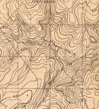
On the 1896/1918 topo map of Chapel Hill the "Fern Bank Walk" is shown on the north bank of Bolin Creek, but Battle clearly states that it was the south bank. There is still a ferny trail through Umstead Park on the south bank of Bolin Creek - at least as popular today as it was 102 years ago. It would be nice to formally designate that as the Fern Bank Walk. And for that matter, there is enough local history in Umstead Park, that it would be nice to have an interpretive sign put there about the mill, the water works etc.

The 1896/1918 topo map shows a number of other sites that are mentioned in Battle's History. I'll do another post on that topic soon.

Sunday, February 22, 2009

Tributaries of Morgan Creek

Having listed out the tributaries of Bolin and Booker Creeks, I suppose I should follow up with the same information on Morgan Creek. So here goes:

Morgan Creek - This creek was named for Mark Morgan and his family, who were early Europeans in the area. The Morgans arrived here before Orange County was formed in 1754, when this was the extreme western frontier of European civilization. In old documents, Morgan Creek is sometimes referred to as Mark's Creek.

Pritchard Branch - This creek drains the Westwood neighborhood in Chapel Hill and the UNC power plant. I have never heard a name for this creek, but it is shown on the Ayers 1954 map of Chapel Hill and Carrboro.

Chapel Spring Branch - This is one of two creeks that form Meeting of the Waters Creek. It rises near the Carolina Inn, although it is buried until it reaches South Road near the Sonja Haynes Stone BCC. The name comes from the fact that the spring at the top of the creek was used for drinking water for the New Hope Chapel which stood about where the Carolina Inn is today. That was the chapel which gave rise to the name Chapel Hill.

Meeting of the Waters Creek - This creek flows into Morgan Creek in the vicinity of the NC Botanical Garden. Old maps of UNC show this creek but do not give a name for it. It seems likely that Kemp P Battle gave this name to the creek, as he mentions it in The History of the University of North Carolina, which was published about 100 years ago. Battle was fond of naming natural features in the vicinity of UNC.

Neville Creek - This creek forms the main western arm of University Lake. The name undoubtedly comes from the name of landowners west of University Lake and Neville Road (which is also out that way) must take its name the same way. The name dates to at least 1891.

Phil's Creek - This creek forms the northwest arm of University Lake. The name appears on the 1891 Tate map, so it is at least that old.

Price's Creek - This is the creek that forms the main southern arm of University Lake. I do not know the origin of the name.

Pritchard's Mill Creek - This is a tributary of Price's Creek just southwest of University Lake. The creek is obviously named for the Pritchard Mill, which once stood just upstream of where Damascus Church Road crosses the creek. Pritchard's Mill has a deep history, but it was owned by the Pritchards during the Civil War. At one time, this creek was called Cumbo Branch.

Wilson Creek - This creek drains the area right around US 15-501 south of Chapel Hill and flows into Morgan Creek right above the 15-501 bridge. In old documents, this creek is referred to as Obed Creek.

Fan Branch - This creek drains out of the area where Southern Village is today and conflows with Wilson Creek just before Wilson Creek flows into Morgan Creek.

Willow Creek - This creek flows throught the western side of Carrboro. I have never ehard it called this name, nor is it labeled this way on any map that I know of, but the creek flows through Willow Creek Shopping Center, I am assuming that the shopping center took its name from the creek.

Chapel Creek - Several modern maps show this name for the tributary of Morgan Creek that is just downstream of Meeting of the Waters Creeek. I am not sure how old that name is and I am not sure that it isn't just a cartographic error - ie that someone is mistaking this for Chapel Spring Banch.

Buck Branch - This creek drains the vicinity of Mt. Carmel Church Road near the Chatham-Orange line, just north of High Hill.

Cub Creek - This creek is the next tributary south of Buck Branch and south of High Hill. It is entirely in Chatham County and drains the vicinity of Governor's Club. Cub Creek flows into Jordan Lake, but historically it was a tributary of Morgan Creek.

Big Branch - This is a tributary of Cub Creek, draining the area just west of High Hill.

Anybody know some other creek names (or origins of creek names)?
Monday, February 16, 2009

The Tributaries of Bolin and Booker Creek

Booker Creek and Bolin Creek flow together to form Little Creek, which ambles a few miles through southwest Durham County before flowing into Jordan Lake.

Little Creek - David Southern tells me that the lower part of Bolin Creek and perhaps Little Creek as well were sometimes known in colonial days as Lick Creek or Barbee Creek.

Booker Creek - Booker Creek was known as Prestwood (or Presswood or Priestwood) Creek before the Revolution. This was apparently after an early European resident named Thomas Prestwood. In 1832, Daniel and David Booker sold their land along this creek, and I assume that they are the source of its modern name (Orange DB 25, pg 428).

Bolin Creek - Bolin Creek takes its name from Benjamin Bolin (or Bowling or Boling or Bollin or Bolins etc. etc. possibly even Borland). Mr. Bolin was granted land along the creek near what is now University Mall (I think including the mall) in 1755. The name pretty well stuck, although it was also sometimes called Ben's Creek (as in Ben Bolin's Creek) and also Wilkinson's Creek (not sure where that came from). In the latter 19th century Bolin Creek was sometimes called Closs Creek after a large landowner named Morgan Closs, but that name apparently did not stick and we all know it as Bolin Creek now.

I know the names of six of Bolin Creek's tributaries, although I think some of the others must have had commonly accepted names at one time. In particular, I have to believe that the branch that flows down through the Cobblestone Drive area of Carrboro must have a name, although I have never heard it. Here are the ones I know:

Battle Branch - This creek flows down through Battle Park and around the north side of the Greenwood neighborhood. It is named (as is the park) for UNC Pres. Kemp Plummer Battle who wandered through this rugged ara of the UNC campus marking trails and building benches, back when he was an undergraduate.

Foxhall Branch - This is the creek that flows near Hillsborough Street in Chapel Hill. I have never actually heard anyone call this creek by that name, but it appears on the 1918 topographic map of Chapel Hill at the Carolina Collection at UNC. So I will go with that until someone tells me a better name.

Tanyard Branch - This creek flows through the Northside neighborhood in Chapel Hill and into Bolin Creek in Umstead Park. The creek is shown on the USGS quadrangle map as Tanbark Branch, but all other maps seem to agree that it is Tanyard. The name would seem to imply that there was a tannery on it somewhere. Anyone know more about that?

Lloyd's Branch - This creek flows through the Lloyd Street neighborhood in Carrboro and into Tanyard Branch, just before Tanyard flows into Bolin Creek. Again, I have never heard anyone call it by this name, but old deeds and surveys from the 1920's call it Lloyd's Branch.

Jolly Branch - This is the creek that flows down from between Chapel Hill High School and Smith Middle School on Seawell School Road. I do not know how old this name is.

Jones Creek - This creek flows through Twin Creeks Park and Lake Hogan Farms in Carrboro. The name appears on the USGS map, but again I don't know how old it is.

Booker Creek also has a couple of named tributaries:

Cedar Fork - This creek flows into the east end of Eastwood Lake, draining through the Cedar Hills Circle area as well as Cedar Falls Park, both of which obviously draw their names from the creek. I don't know how old this name is, but it appears on the 1918 Soil Map of Orange County.

Crow Branch - This creek flows into Booker Creek just below Lake Ellen in Chapel Hill, draining from the Horace Williams tract (Carolina North). The name also is on the 1918 Soil Map and again don't know hwo much older than that it may be.