Sunday, December 20, 2009

The Everard Tract

Sometime between 1728 and 1730, Governor Richard Everard received a grant of land just north of the Forster and Moseley Tracts in the Hawfields. Neither Forster's nor Moseley's grant mention Everard, so perhaps he acquired his interest somewhat after them. We cannot be sure when exactly as no copy or description of the original grant was ever recorded. An execution deed in 1770 in the Orange Deed Books shows that the Everard Tract had been 10,000 acres, but it gives no indication of the shape.

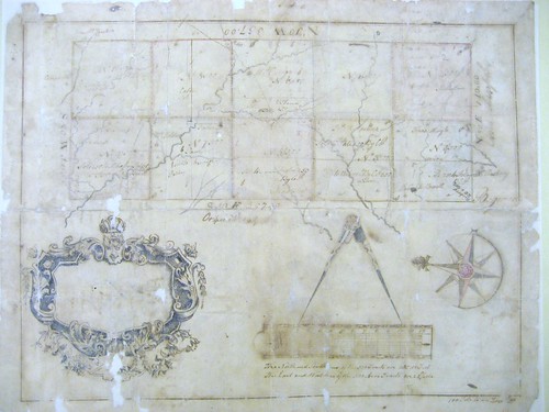
So until recently it seemed that no detailed record remained of the grant of 10,000 choice acres in the Hawfields to Gov. Richard Everard. Then I found this in the Devereux Papers at the Archives:

IMG_2350

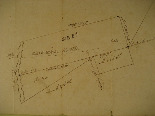
Evidently this is a survey of the land of Sir Richard Everard, with Forster and Moseley shown as neighbors to the south, and with Lovick and Little rather hypothetically shown. This seems to be a survey of the Everard Tract only, as all of property lines for Moseley and Forster are shown schematically – that is the surveyor was making no real assertion about the Forster or Moseley Tracts. Also in one place is says “Mo now St” – Moseley now Strudwick – indicating that the survey was done after Strudwick received the property in 1754.

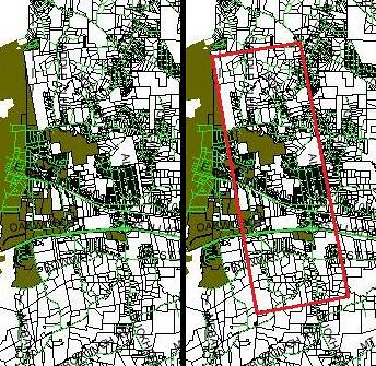
Considering the terms of the Moseley grant and the Pollock grant, it is clear that the southeastern corner of the Everard Tract was also the northwestern corner of the Pollock Tract. Therefore, using the metes and bounds of the Everard Plat, we can place this tract onto a modern map:

Everard_Tract[1]

The ford marked on the plat is therefore clearly Trollinger's Ford, earlier known as the Piney Ford and no doubt known by native names before that.

Everard died in 1733 and the Everard Tract passed to his daughters Anne Everard Lathbury (et ux. George) and Susannah Everard Meade (spouse deceased?) In 1770, Lathbury's 10,000 acres were sold by court order to satisfy a judgment from Halifax Court on an unrelated matter. At the auction, three well-known Hillsborough men, Edmund Fanning, Abner Nash and Thomas Hart, bought the Everard Tract for 670 Pounds (24 S.R. 285; p. 45, 2nd Report of the Ontario Archives, Alexander Fraser, 1904). Only a few years later the Revolution broke out and both Fanning and Hart fled North Carolina.

I take it this refers to Fanning’s 1/3 interest in this parcel: “5000 acres, Hawfields, Orange County, purchased in July, No.19. 1770, of John Butler, valued by Mr. Johnston at 40 sh. Virg. per acre, £10,000 V. Curry.” (p. 45, 2nd Report of the Ontario Archives, Alexander Fraser, 1904). It would have been more accurate to say 3,333 acres, I believe.

Nash worked to disentangle his interest in the Lathbury-Everard Tract from his Loyalist co-adventurers. At least two letters from Nash are still to be found at the State Archives regarding his efforts to get a separate deed for his 1/3 of the property. Ultimately in 1779 Nash got the state legislature to order a division of the land (24 S.R. 285). Few immediately subsequent deeds from Nash can be found today, but it appears that at least part of it went to John Butler (ODB 3, pg 462).

Curiously the Virginia Gazette (6/4/1772) advertised “SEVERAL valuable Tracts of TOBACCO LAND, the Whole consisting of about ten Thousand Acres, well watered, situated on the Waters of Rock Creek and Saxapahaw River, to which is contiguous a very good Summer Range, and many other Advantages. Twelve Tracts, containing from about two Hundred and fifty to six Hundred Acres, are already surveyed, and several more will be when Purchasers offer . . . the Lands are situated in the Haw Fields, twelve Miles beyond Hillsborough, and bounded by Haw River . . . GEORGE LATHBURY, G. WALKER, Attorney for Susanna Meade.”

Additionally, I found a Power of Attorney recorded in the Orange Deed Books from Susanna Meade to G. Walker granting him authority to sell or otherwise manage her interest in 10,000 acres which she co-owned with George Lathbury - plainly the Everard Tract. Susanna Everard Meade was Anne Everard Lathbury’s sister, both daughters of Gov. Everard. Notably this was in 1772, after the property had already sold in 1770 to Fanning et al. Perhaps they did not know about the execution sale or were otherwise attempting to have the execution sale set aside.

Saturday, December 19, 2009

The Pollock Tract 1

Recently David Southern drew my attention to a barely legible, yet very interesting surveyor’s plat of land in Orange County owned by the Pollock family:

Pollock Plat

The State Archives, which has the original, dates the survey to 1754, although it bears many later notes about persons to whom parts of the land were sold. The notes show a lot of interesting detail including four different roads and at least thirteen houses. Thinking it would be interesting to locate this on the ground today, I set about to decipher the location shown on the Pollock Plat.

George Pollock appears to have patented two tracts in the Hawfields. The first Pollock Tract in the Hawfields was 5,000 acres (see Orange DB 3, pg 562; Orange DB 4, pg 219). I will blog about the second Pollock Tract another time. Unlike most of the Hawfields Grantees of 1728, the Pollocks did not immediately re-sell Pollock Tract 1. George Pollock still owned the tract when he died in July of 1738; George's will left many large tracts across eastern NC to relatives, including this 5,000 acres in the Hawfields to his nephews Cullen and Thomas Pollock (Land Grant Records Book 4, pg 82).

Apparently the patents for the Pollock Tracts in the Hawfields were never recorded, making the project of locating them on the ground more difficult. Although, I did know approximately where the Pollock Tract was because it was adjacent to the long eastern edge of Edward Moseley’s Tract in the Hawfields (N10W). But exactly where that line was (and therefore where the Pollock Tract was) remained difficult to determine. In fact there appears to have been some dispute about the location of that line, as Cullen Pollock and Moseley's successor Samuel Strudwick entered into an agreement about that boundary. The agreement was recorded twice – in 1780 and again in 1786 (ODB 2, pg 444; ODB 5, pg 772), but alas it only references a survey, which is not recorded.

The detailed creeks shown on the plat were also an important clue, but then one night I looked at the Orange County GIS system in the area of Efland and I saw this:

pollock tract

The left side of the image shows the vicinity of Efland. The right side shows the same area, but with Pollock Tract 1 outlined in red. Even today, the outlines of Pollock Tract 1 can plainly be seen on Orange County’s GIS system. And it measures out to 5,000 acres and it is 560 poles by 1428 poles – just as the Pollock Plat calls for.

Although the original grant is missing, the circumstances of the grant are still quite discernible. The Colonial Records of North Carolina (3 C. R. 248) show that on May 22, 1731, John Lovick testified at Governor George Burrington’s inquiry into the legitimacy of the various Hawfields grants: “when the line was for to run betwixt this Government and Virginia there being no money belonging to the lords Proprietors in their Receivers hand to defray the charge the Gov. & Council passed an order for the sale of Lands to Reimburse it & thereupon the line was run to general satisfaction & at a charge that has been thought no way immoderate, your Remonstrant being one of the commissioners. The credit of that Order of the Board advanced great sums of money towards the defraying of the charges and had lands afterwards assigned to him to reimburse the same and upon it sold out to Mr. George Pollock 17,000 acres . . .”

However as part of the same inquiry, others, such as Thomas Jones, testified that it happened a bit differently: “[Jones had] an Imaginary survey in the month of June Last [1730]. He produced the same to Mr. Lovick who filled up a Patent for the said Land in August or September Last [1730, but] Dated in the year 1728.” And there were others who seriously called into question the circumstances of these sales. Most land grants at that time were not more than 640 acres, so all of the Hawfields grants were dubious that way. And it is certainly a reasonable inference that many of these powerful men may have taken advantage of the 2-year period between the end of the Governor Richard Everard’s authority under the Lords Proprietor and the arrival of the King’s new Governor, George Burrington.

All of the surviving recorded Hawfields grants are found in a group in Land Grant Book 2, and each of those is followed immediately by a deed from the original grantee to Burrington. All but one of the original grants are dated 1728, but were not recorded until the end of 1730 at the exact same time that they were further conveyed to Gov. Burrington, who conveniently soon became the judge of the validity of these grants. The one Hawfield grant that is not dated 1728 was the Conner Tract; Conner's grant, as recorded in Land Grant Book 2, appears to have been patented just one week before it was resold to Burrington (possibly a transcription error or alternatively an all too frank admission of how crooked this all was). It seems reasonable to wonder whether any of these grants were truly properly issued. Perhaps the Hawfields grants were all a bunch of mischief cooked up in Burrington’s absence, but back-dated to appear as though they had been executed during the Proprietorship when Everard’s government had the authority to issue patents.

Unfortunately, few of the subsequent deeds from the Pollocks were recorded in Orange County Deed Books. However, the State Archives holds a remarkable collection of Pollock deeds and surveys in the Devereux Papers. Among these is a survey of the Pollock Tract from 1754 (Appendix 3). This plat was used by Cullen Pollock to keep track of the various parcels that he and his brother sold to settlers in the area.

The 1754 Pollock Plat records Cullen Pollock’s sales: Tract 1- Hans Hingle, Warson?, and Robert Hollowell, Tract 2 - Mulhollan, Tract 3 - James Kirkpatrick, [George?] Tate and Wilson, Tract 5 – [David?] Duglas, and David Steel, Tract 6 - William Craige and Ed Thomas, Tract 7 - John Long, Holden?, Paisley, [Archibald?] Hamilton, Tract 8 - Cate, Tract 9 - Joseph Sharp, Patent [Patton], Mihaffey, [Peter?] Mallett, and William Ellis, Tract 10 - Jonathan ???ein and Bradford. The plat also shows that Campbell and John McCracken lived just north and east of the Pollock Tract; William Raspberry is shown just south of the Pollock Tract, along Buckhorn Road; and Mulholland is shown just east of Tract 4.

According to the Orange County Register of Deeds, Cullen Pollock sold parcels to: David Gibson (ODB 5, pg 99), David Douglas, adjacent to George Tate (ODB 3, pg 561), Henry Patillo in 1789 (ODB 4, pg 219), Andrew Pattent in 1772 (ODB 34, pg 11), and Thomas Bradford in 1786, adjacent to Andrew Patent and David Bradford (ODB 3, pg 170). George Pollock (a son of Cullen?) sold land to Thomas Ruffin in 1811 (ODB 16, pg 104). [Gracious thanks to Carole Troxler for assistance with this information.]

The following are very brief abstracts of further deeds in the Devereux papers: To Robert Holloway near the Great Road, corner of George Tate. To George Tate on the Great Road. To Edward Willson on Tate’s line, Holloways corner. To David Douglas at Tate’s corner, on Willson’s line. To David Bradford.

The Great Road evidently refers to where Old Hillsborough Road and Bowman Road are now, the old Trading Path.

Sunday, December 13, 2009

The Butler Petition

I found a petition in the Archives in a box of Court Records related to old real estate disputes in Orange County. I think the petition refers to the plight of those who came in the 1740's and occupied the lands that John Forster, William Little and John Lovick patented in 1728:

Alston Quarter 1763 small

While the squatters on the Moseley and Conner tracts ended up fighting Samuel Strudwick (successor to Moseley and Conner) over the title to the farms they built, the squatters who occupied the Forster, Little and Lovick Tracts never heard from the British citizens who held nominal title to this land. So when the local Commissioner of Confiscation came along and attempted to sell the nominal title to these lands, the squatters, who by that time had become propsperous and important residents of Orange County, got their most prominent figure, Gen. John Butler, to lead the charge in defending their farms from confiscation:

"To the worshipful Justices of the Court of Pleas and Quarter Sessions for the County of Orange:

"The Petition of the subscribers, citizens of the State of North Carolina and Inhabitants of the County of Orange humbly sheweth

"That many and by far the greater part of your petitioner more than forty years ago seated themselves upon the lands which they now occupy in the County of Orange. From the first settlement of them unto this time, your petitioners or those under whom they hold by fair honest and bona fide purchase have had and held quiet and undisturbed possession. That out of the wilderness by the sweat of their brows they have cleared and cultivated many valuable plantations made extensive improvements, erected convenient buildings and flattered themselves that they should without molestation been permitted to enjoy the fruits of their labours. That in this confidence they have bound their views to the soil upon which they have planted themselves and devoid of every other resource of subsistence to be now forced from it would necessarily involve their utter ruin.

"They have been guilty of no conduct in the late war which could mark them for the resentment of Government and subject them to forfeiture. On the contrary they stept forth in an early stage of the war and during the most critical and trying periods have vigorously contended for the liberty and independence of America; they flattered themselves that in common with their fellow citizens they should enjoy the blessings of the late glorious revolution; that they should not be distinguished as sufferers by an event which they had so liberally contributes to bring about. Judge of their astonishment when they were informed that under an ideal and imaginary claim of certain persons now or heretofore resident in the Kingdom of Great Britain, some persons had been induced to conceive that the lands upon which your Petitioners are seated by some one of the confiscation laws of this State were subjected to forfeiture and that the commissioners of confiscation in pursuance of this opinion had advertised them for sale.

"It is by no means necessary at present nor would it come properly before your Worships that your Petitioners should condescend to a detail of their several titles, their well founded pretensions against the claims of all persons. It is sufficient at present to say that their original entry was rightful & peaceable; that it has been sanctioned by grants from government and that they have held a long and undisturbed possesion; That in the course of forty years neither those who are now suggested to be the original patenter by those who are opposed to your Petitioners, nor any others claiming by from or under them have by such, at law or otherwise, attempted to evict your Petitioners.

"Your Petitioners claim the common right of Citizens and if their property is to be drawn into question, they expect that they are not to be denied the constitutional privilege of a trial by Jury. Their possessions individually to the publick are but a small stake, but to themselves it is their all, and surely they are not to be stripped of them upon ideal suspicion or vague conjecture.

"Your Petitioners are well aware that if the Commissioner of Confiscation should proceed to sell that yet it must be left to a court of law to award possession and that this could not take place but upon a full investigation of the titles of your Petitioners. But your Worships will foresee the unavoidable consequences, tis? many suits will be brought as there are purchasers and however well established the title of your petitioners may be in the event the value of many of their plantations will be sunk in other ?am? upon the courts the laws delay and the unavoidable expense attending it.

"Their circumstances they took up to your worships and request you to interfere with the authority derived to you from the eighth section of the Act of Assembly passed at Newbern in the year 1779 and on the eighteenth day of October entitlted an “Act to carry into affect and act passed at Newbern in November in the year 1777 entitled an act for confiscating the property of all such persons as are inimical to the United States and of such persons as shall not within a certain time therein mentioned appear and submit to the State whether they shall be received as citizens thereof and of such persons who shall so appear and shall not be admitted as citizens and for other purposes therein mentioned.

"The clauses to which they refer and which they humbly conceive is apt to their case and was intended to give them relief in circumstances similar to there are as follows: Provided that if it shall appear to the county court that any person hath or pretends to have any right or title in law to any lands tenements or hereditaments monies debts or personal property of any of any of the said persons declared forfeited by this act, such court shall stay all further proceedings thereupon and shall send up a true and exact state[ment] of such claim to the superior court of the district which superior court shall proceed to inquire into the legal right and title of the person so claiming by a Jury in the same manner as suits at common law and such determination when had shall be final and the Clerk of Superior Court chall transmit a copy thereof to the county court wherein the dispute originated which shall proceed according to such determination.

"Your Petitioners humbly hope that you will extend the operation of this law to their relief and make such order as will prevent any further proceedings being had by the Commissioner respecting the premises before the calims of your petitioners shall be heard and decided upon as the law directs.

"And your Petitions as in duty bound will ever pray,

"Eli McDaniel, Richard? Hunter, David Sealy, Robert Sealey, Walter Burnside, James Trousdale, Jane Patin, Archibald Maben, Nathaniel Patterson, Moka? Crawford, Jos. Hodge, George Allen, James Turner, James Truit, William Hodge, William Und????, John Allen, Samuel Shaw, Ephraim Tur???, John McDaniel, John Butler, John Armstrong, John Hamish, William Galbreath, James Cokeley, Richard Scott, John Hodge, Stephen White, John Pattin, Alexander Kirkpatrick, Samuel Pattin, Griffith Thomas, Robert Pattin, John McCrackin, John Baldridge, Nicholas Cane?, Henry Basin, Andrew Mundary? James Dixon, John Galbreath, Anthony Standford, John Basin, Timothy Hughes, Joseph Baker, James McAdams, William Raney, and Daniel Hanley."

Friday, December 11, 2009

A Sketch of Thomas Cate, founder of Cane Creek Baptist Church

Here's an excerpt from the Cane Creek Baptist Church website:

http://www.canecreek.org/Documents/History/History.html

"Thomas Cate was born about 1747 and was the son of Thomas and Rebecca Sykes Cate who had migrated to Orange County from Prince George County, Virginia where the family had been Quakers. He had brothers named Barnard, John, and Richard. He married Sarah Estridge about 1767. His wife's last name is in dispute with some thinking that she was a Shepard. I can find no trace of Shepards in our local records On the other hand, there is a faint record of an Estridge family locally (sometimes recorded as Estes). This is mentioned in grants located to the northeast of Cane Creek. I suspect that the Estridges were Tories who may have left the community during the Revolutionary War.

"Thomas Cate's will mentions eleven children: Moses born about 1768 who married Hannah Bradford; John B. born about 1770 who married Priscilla Lloyd and who died in Tennessee in 1840; Fanny, born about 1772 who married John Sykes; Martha, birth date unknown, who married William Moore; Winny [Minny?] birth date unknown, who married William Roach, Huldah, birth date unknown, who married Elisha Cates, possibly a cousin; Tabitha, date of birth unknown, who married William Smith; Elizabeth, possibly born in 1784, whose marital status is confused; Thomas, born in 1784, who married Elizabeth Roach, and later Martha Carroll and who died in 1863; Ephraim, born about 1778, who married Rebecca Lindsey and who died in Missouri in the 1850's. The name of the eleventh child is unknown.

"From other sources, we know that Thomas Cate was an assistant preacher with Haw River Baptist Church (near Bynum) before establishing our church. He had probably been baptized by the Haw River preacher, Elnathen Davis, who himself had been baptized by Shubal Stearns who established the first Baptist church in this part of the state in 1756. It is a mystery why Cane Creek, established by a Baptist preacher, did not declare itself a Baptist church until the 18th year of its existence, in 1806.

"In his will, Thomas left his sons 500 acres. The inventory also mentions three slaves, smith tools, wagons, horses, two stills, boars, hogs, sheep, etc, all to be equally divided among the eleven children. The inventory lists property sold, to whom sold, and the amount paid. The total is $899.66. Another sale that brought in $1263 was conducted in 1825, following the death of Sarah.

"The inventory suggests that Thomas Cate was a fairly prosperous farmer." - Edward Johnson