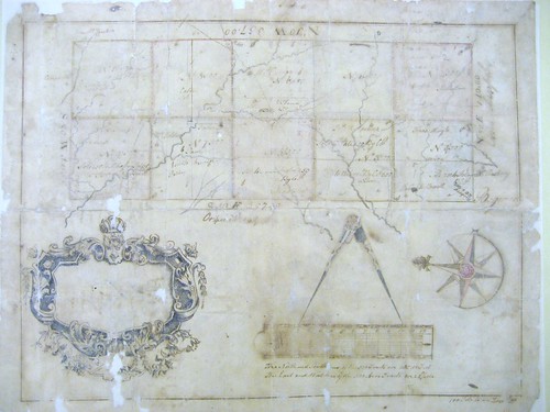
The State Archives, which has the original, dates the survey to 1754, although it bears many later notes about persons to whom parts of the land were sold. The notes show a lot of interesting detail including four different roads and at least thirteen houses. Thinking it would be interesting to locate this on the ground today, I set about to decipher the location shown on the Pollock Plat.
George Pollock appears to have patented two tracts in the Hawfields. The first Pollock Tract in the Hawfields was 5,000 acres (see Orange DB 3, pg 562; Orange DB 4, pg 219). I will blog about the second Pollock Tract another time. Unlike most of the Hawfields Grantees of 1728, the Pollocks did not immediately re-sell Pollock Tract 1. George Pollock still owned the tract when he died in July of 1738; George's will left many large tracts across eastern NC to relatives, including this 5,000 acres in the Hawfields to his nephews Cullen and Thomas Pollock (Land Grant Records Book 4, pg 82).
Apparently the patents for the Pollock Tracts in the Hawfields were never recorded, making the project of locating them on the ground more difficult. Although, I did know approximately where the Pollock Tract was because it was adjacent to the long eastern edge of Edward Moseley’s Tract in the Hawfields (N10W). But exactly where that line was (and therefore where the Pollock Tract was) remained difficult to determine. In fact there appears to have been some dispute about the location of that line, as Cullen Pollock and Moseley's successor Samuel Strudwick entered into an agreement about that boundary. The agreement was recorded twice – in 1780 and again in 1786 (ODB 2, pg 444; ODB 5, pg 772), but alas it only references a survey, which is not recorded.
The detailed creeks shown on the plat were also an important clue, but then one night I looked at the Orange County GIS system in the area of Efland and I saw this:
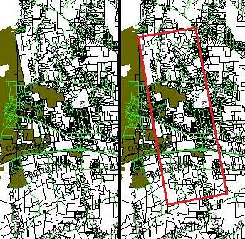
The left side of the image shows the vicinity of Efland. The right side shows the same area, but with Pollock Tract 1 outlined in red. Even today, the outlines of Pollock Tract 1 can plainly be seen on Orange County’s GIS system. And it measures out to 5,000 acres and it is 560 poles by 1428 poles – just as the Pollock Plat calls for.
Although the original grant is missing, the circumstances of the grant are still quite discernible. The Colonial Records of North Carolina (3 C. R. 248) show that on May 22, 1731, John Lovick testified at Governor George Burrington’s inquiry into the legitimacy of the various Hawfields grants: “when the line was for to run betwixt this Government and Virginia there being no money belonging to the lords Proprietors in their Receivers hand to defray the charge the Gov. & Council passed an order for the sale of Lands to Reimburse it & thereupon the line was run to general satisfaction & at a charge that has been thought no way immoderate, your Remonstrant being one of the commissioners. The credit of that Order of the Board advanced great sums of money towards the defraying of the charges and had lands afterwards assigned to him to reimburse the same and upon it sold out to Mr. George Pollock 17,000 acres . . .”
However as part of the same inquiry, others, such as Thomas Jones, testified that it happened a bit differently: “[Jones had] an Imaginary survey in the month of June Last [1730]. He produced the same to Mr. Lovick who filled up a Patent for the said Land in August or September Last [1730, but] Dated in the year 1728.” And there were others who seriously called into question the circumstances of these sales. Most land grants at that time were not more than 640 acres, so all of the Hawfields grants were dubious that way. And it is certainly a reasonable inference that many of these powerful men may have taken advantage of the 2-year period between the end of the Governor Richard Everard’s authority under the Lords Proprietor and the arrival of the King’s new Governor, George Burrington.
All of the surviving recorded Hawfields grants are found in a group in Land Grant Book 2, and each of those is followed immediately by a deed from the original grantee to Burrington. All but one of the original grants are dated 1728, but were not recorded until the end of 1730 at the exact same time that they were further conveyed to Gov. Burrington, who conveniently soon became the judge of the validity of these grants. The one Hawfield grant that is not dated 1728 was the Conner Tract; Conner's grant, as recorded in Land Grant Book 2, appears to have been patented just one week before it was resold to Burrington (possibly a transcription error or alternatively an all too frank admission of how crooked this all was). It seems reasonable to wonder whether any of these grants were truly properly issued. Perhaps the Hawfields grants were all a bunch of mischief cooked up in Burrington’s absence, but back-dated to appear as though they had been executed during the Proprietorship when Everard’s government had the authority to issue patents.
Unfortunately, few of the subsequent deeds from the Pollocks were recorded in Orange County Deed Books. However, the State Archives holds a remarkable collection of Pollock deeds and surveys in the Devereux Papers. Among these is a survey of the Pollock Tract from 1754 (Appendix 3). This plat was used by Cullen Pollock to keep track of the various parcels that he and his brother sold to settlers in the area.
The 1754 Pollock Plat records Cullen Pollock’s sales: Tract 1- Hans Hingle, Warson?, and Robert Hollowell, Tract 2 - Mulhollan, Tract 3 - James Kirkpatrick, [George?] Tate and Wilson, Tract 5 – [David?] Duglas, and David Steel, Tract 6 - William Craige and Ed Thomas, Tract 7 - John Long, Holden?, Paisley, [Archibald?] Hamilton, Tract 8 - Cate, Tract 9 - Joseph Sharp, Patent [Patton], Mihaffey, [Peter?] Mallett, and William Ellis, Tract 10 - Jonathan ???ein and Bradford. The plat also shows that Campbell and John McCracken lived just north and east of the Pollock Tract; William Raspberry is shown just south of the Pollock Tract, along Buckhorn Road; and Mulholland is shown just east of Tract 4.
According to the Orange County Register of Deeds, Cullen Pollock sold parcels to: David Gibson (ODB 5, pg 99), David Douglas, adjacent to George Tate (ODB 3, pg 561), Henry Patillo in 1789 (ODB 4, pg 219), Andrew Pattent in 1772 (ODB 34, pg 11), and Thomas Bradford in 1786, adjacent to Andrew Patent and David Bradford (ODB 3, pg 170). George Pollock (a son of Cullen?) sold land to Thomas Ruffin in 1811 (ODB 16, pg 104). [Gracious thanks to Carole Troxler for assistance with this information.]
The following are very brief abstracts of further deeds in the Devereux papers: To Robert Holloway near the Great Road, corner of George Tate. To George Tate on the Great Road. To Edward Willson on Tate’s line, Holloways corner. To David Douglas at Tate’s corner, on Willson’s line. To David Bradford.
The Great Road evidently refers to where Old Hillsborough Road and Bowman Road are now, the old Trading Path.


No comments:
Post a Comment