Here’s a detail of the 1890 Tate Map of Orange County, showing the area where Carrboro is today:
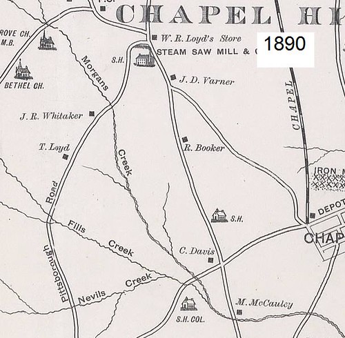
Clearly what is now Greensboro Street existed at that time, as did Old Fayetteville Road and Jones Ferry Road. Notice that Old Fayetteville Road crosses Morgan Creek and continues south. If you were to trespass on OWASA property, you could see the last remnants of this dilapidated bridge just below the University Lake Dam. This map shows a school house along Old Fayetteville Road a bit north of Jones Ferry. I don’t know where that was, but it must have been near Chateau Apartments. Also there’s an African-American schoolhouse on Jones Ferry, presumably at the present-day location of Old School Road just past University Lake.
Calvander is shown as a slightly more complicated intersection in 1890 than it is today. It is where it says W. R. Lloyd Store. There’s an extra road coming off to the southwest and crossing Morgan Creek. This road does not exist today, but it crossed Morgan Creek somewhere south of Dairyland Road and north of NC-54 (which is totally absent from this map because it was built in 1928 or so).
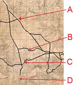
This is a 1918 topographic map of the Chapel Hill area. I zoomed in on Carrboro and darkened in the roads so that you can read it better. Notice, first that at “D” the bridge is now gone and Old Fayetteville Road no longer crosses Morgan Creek. Marker “C” shows where Jones Ferry Road is, but on this map there is also a similar road to the north. Road “B” is apparently West Poplar Avenue. Weaver Street and Part of West Main Street seem to be in place as well.
Marker “A” points to a mystery road. There’s no road there now as far as I know, and it appears to pass through what is now McDougle School. As it crosses Old Fayetteville Road, that road becomes what we now call Russell Ford Road, which certainly implies that there was once a place on Morgan Creek called Russell Ford, this is presumably where the 1890 road coming SW out of Calvander also went. I think I know just where that was and I’ll explain a little more below.
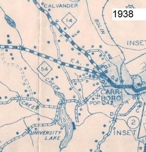
This is a detail of the 1938 NC Highway Department Map of Orange County. In this map, West Main Street has become much more prominent, as has the rest of NC Highway 54. Now Old Greensboro Highway (OGH) shows up, veering off of Jones Ferry Road. The OGH bridge over the Haw was built about 1913, although OGH is not shown in the 1918 map above.
Now looking at the bodies of water shown, notice first, that University Lake has formed. The dam was built in the 1920’s on the former McCauley Mill site (first developed as a mill before 1800). Also in the northwest corner of the map there is a smaller pond. This is a site that I call the Lloyd Mill. The remains of the dam that formed this mill pond are still quite discernible along that banks of Morgan Creek near where the powerline crosses Morgan Creek a mile or so north of Highway 54. The raceway coming form the dam is apparent as well. I am not exactly sure that the Lloyd’s owned it, but I think so. The Lloyd family conveyed a mill on Morgan Creek which I can’t link up with any other site, so I assume it was this one. I also reckon that this is where Russell Ford Road came to, right at the end of the millrace. If you walk back there, you can see a spot that still looks somewhat fordable today. Here’s a picture of the old road bed leading to Russell Ford from the west:
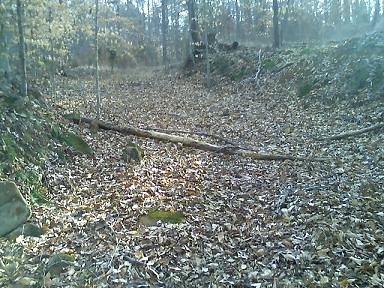
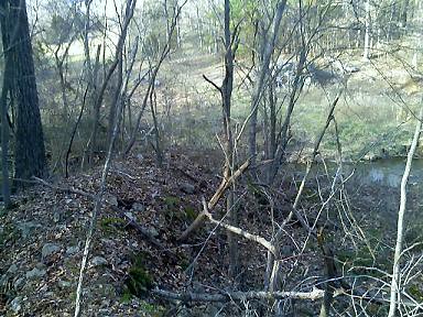
It can be hard to photograph the ruins of an old dam, but here is my attempt. In the foreground you can see the west shoulder of the dam. On the east side, the dam terminated in a large rock outcropping, which is only barely visible in this shot:
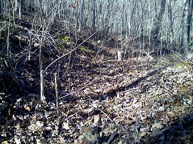
I don’t know how well you can make this out, but below is a shot of the abandoned millrace. The race is basically just a ditch that conveyed water along the bank, as high as possible above the creek, down to the mill, which stood right next to Russell Ford. This picture is taken looking northward up the millrace:

Clearly what is now Greensboro Street existed at that time, as did Old Fayetteville Road and Jones Ferry Road. Notice that Old Fayetteville Road crosses Morgan Creek and continues south. If you were to trespass on OWASA property, you could see the last remnants of this dilapidated bridge just below the University Lake Dam. This map shows a school house along Old Fayetteville Road a bit north of Jones Ferry. I don’t know where that was, but it must have been near Chateau Apartments. Also there’s an African-American schoolhouse on Jones Ferry, presumably at the present-day location of Old School Road just past University Lake.
Calvander is shown as a slightly more complicated intersection in 1890 than it is today. It is where it says W. R. Lloyd Store. There’s an extra road coming off to the southwest and crossing Morgan Creek. This road does not exist today, but it crossed Morgan Creek somewhere south of Dairyland Road and north of NC-54 (which is totally absent from this map because it was built in 1928 or so).

This is a 1918 topographic map of the Chapel Hill area. I zoomed in on Carrboro and darkened in the roads so that you can read it better. Notice, first that at “D” the bridge is now gone and Old Fayetteville Road no longer crosses Morgan Creek. Marker “C” shows where Jones Ferry Road is, but on this map there is also a similar road to the north. Road “B” is apparently West Poplar Avenue. Weaver Street and Part of West Main Street seem to be in place as well.
Marker “A” points to a mystery road. There’s no road there now as far as I know, and it appears to pass through what is now McDougle School. As it crosses Old Fayetteville Road, that road becomes what we now call Russell Ford Road, which certainly implies that there was once a place on Morgan Creek called Russell Ford, this is presumably where the 1890 road coming SW out of Calvander also went. I think I know just where that was and I’ll explain a little more below.

This is a detail of the 1938 NC Highway Department Map of Orange County. In this map, West Main Street has become much more prominent, as has the rest of NC Highway 54. Now Old Greensboro Highway (OGH) shows up, veering off of Jones Ferry Road. The OGH bridge over the Haw was built about 1913, although OGH is not shown in the 1918 map above.
Now looking at the bodies of water shown, notice first, that University Lake has formed. The dam was built in the 1920’s on the former McCauley Mill site (first developed as a mill before 1800). Also in the northwest corner of the map there is a smaller pond. This is a site that I call the Lloyd Mill. The remains of the dam that formed this mill pond are still quite discernible along that banks of Morgan Creek near where the powerline crosses Morgan Creek a mile or so north of Highway 54. The raceway coming form the dam is apparent as well. I am not exactly sure that the Lloyd’s owned it, but I think so. The Lloyd family conveyed a mill on Morgan Creek which I can’t link up with any other site, so I assume it was this one. I also reckon that this is where Russell Ford Road came to, right at the end of the millrace. If you walk back there, you can see a spot that still looks somewhat fordable today. Here’s a picture of the old road bed leading to Russell Ford from the west:

It can be hard to photograph the ruins of an old dam, but here is my attempt. In the foreground you can see the west shoulder of the dam. On the east side, the dam terminated in a large rock outcropping, which is only barely visible in this shot:

I don’t know how well you can make this out, but below is a shot of the abandoned millrace. The race is basically just a ditch that conveyed water along the bank, as high as possible above the creek, down to the mill, which stood right next to Russell Ford. This picture is taken looking northward up the millrace:

No comments:
Post a Comment