Here's the detail from the Bean map:
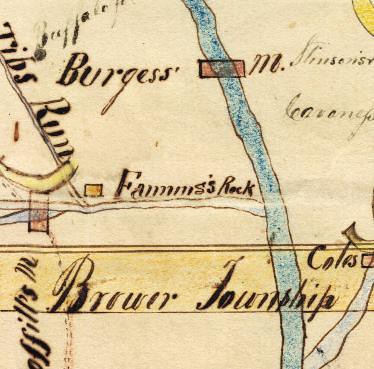
It seems likely that it would be easy to find the rock that this map is referring to, as it must be the most prominent rock outcropping in the vicinity of the Riverside Road bridge over Richland Creek.
I noticed that this same spot on the 1884 Johnson Map of Ranolph County is also shown as Fanning's Rock, but interestingly just a mile or so to the east of it, there is another spot labeled "Fanning's Rock and Cave." This second spot is on Brush Creek a little downstream of the NC 22 bridge. Here's the detail from the Johnson map:

Googling "Fanning's Rock" didn't turn up any references to either of these spots. Anyone out there know what the story is?


I looked at Branson's 1894 Randolph County Business Directory today and noticed that Fanning Rock is labeled in the map in that book, as is Fanning's Rock & Cave.
ReplyDelete