For example, J. A. Blair in his book Reminiscences of Randolph County (1890) acknowledges that he is unsure of where Cox’s mill was: “Thomas Cox had a mill somewhere on Deep River in 1784.” And the NC Highway Historical Marker in Ramseur is also somewhat equivocal, stating that Cox’s Mill was “4 ½ miles southeast, near site of present ‘Bean’s Mill.’”
Places which are not Cox’s Mill on Deep River
Part of the problem in sorting out the location of Cox’s Mill is that the Cox family was heavily involved in water-powered industries in Randolph County. Two places that can quickly be dismissed as possible sites of Cox’s Mill are Cox Lake on the Deep River and Cedar Falls.
It seems obvious that Cox Lake was developed by members of this same Cox family, but after an in-depth search, I am pretty sure that the site of the Cox Lake Dam was not developed for water power prior to 1924. Saville (1924) makes reference to the Cox Lake Dam as being under construction at the time of his report. Prior to the construction of Cox Lake, there was another mill dam just a few miles upstream, the Central Falls Dam. Topographically, the Central Falls site and the Cox Lake site could not have been used for waterpower at the same time. In short, I don’t think the Cox Lake site was ever developed as a mill before 1924.
Blair (1890) mentions that Cedar Falls Manufacturing Co. was owned by several people including Orlando R. Cox. Again this is doubtless a member of the same Cox family, but the Cedar Falls mill site was originally owned by Regulator Harmon Husbands and passed into the hands of Benjamin Elliott in 1801. Eventually the site was redeveloped into a textile mill by Elliott and his partners, but the Cox family did not become involved at this location until much later.
Also, neither of the sites work as theories for the site Cox’s of Mill because Revolutionary histories all agree that Cox’s Mill was near the Buffalo Ford, significantly downstream of both Cox Lake and Cedar Falls, nearer to Coleridge, NC. Also, Cox Lake and Cedar Falls are both north of the historical marker in Ramseur, rather than southeast of it.
Places which are Cox’s Mill but not on Deep River
Speaking again of the historical marker, let’s turn our attention to the statement that Cox’s Mill was “near present site of Bean’s Mill.” Bean’s Mill is on Mill Creek near Mill Creek Road, a short distance above the confluence of the creek with the Deep River. I think many modern writers assume that Bean’s Mill stands directly on the Cox’s Mill site, but I doubt that.
First, as early as Nov. 1763 (Minutes of Ct of Pleas and Quarter Sessions), Cox’s Mill is referred to as being “on Deep River,” rather than near Deep River. And Revoultionary War histories also frequently and typically use the preposition “on,” rather than “near.”
Second, Martin (1993) states that there were two Cox’s Mills – one owned by Harmon Cox, a Quaker and Regulator, and the other owned by Harmon’s father William Cox. On the Asheboro Chamber of Commerce website, an essay attributed to Emily Cox Johnson states:
“One of the gristmills was located west of Deep River onMill Creek and run by Thomas Cox . . . A second was locatedless than a mile away on the east side of Deep River on Millstone Creekand run by Harmon Cox, a brother of Thomas Cox. The reason twogristmills were being run by a single family so close together was thefact that Deep River is prone to serious flooding any time during theyear. These ravaging floods often render Buffalo Ford, which connectsthe two mills, impassable for several weeks at a time.”
Certainly Ms. Johnson’s account is consistent with 19th century maps of the area:
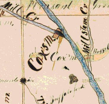
The 1873 Bean Map of Randolph County
But Ms. Johnson is non-committal about whether the site of Fanning’s Headquarters was Harmon Cox’s Mill on Millstone Creek or Thomas Cox’s Mill on Mill Creek.
While I believe Ms. Johnson’s account and find it eminently logical, I doubt it in one major regard: I think that one or both of these mills may have been built shortly after the Revolutionary War to address the issue of flooding on the Deep River – not merely the problem of the flooding of Buffalo Ford, but also the destruction of the original Cox’s Mill – the one that Fanning used as his headquarters – the one that was “on Deep River” – William Cox’s Mill.
Cox’s Mill on Deep River
For the 1880 Census, George Swain prepared a disquisition on the waterpower sites of the southeastern United States. In his description of the Deep River, Swain mention “Unimproved site 2 or 3 miles above Enterprise mills [Coleridge, NC], known as the Cox falls, supposed to have a fall of 12 or 14 feet.” In an 1899 report, Swain further described “Cox’s Shoal” as being 3 miles above Coleridge and having a 7 foot fall spread across 300 yards.
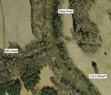
I concede that this is just speculation and that it runs contrary to the prevailing school of thought, but I believe that Cox’s Shoal, as described by Swain is the actual site of Fanning’s headquarters and William Cox’s Mill on Deep River. I also believe that a closer search of Randolph County land records and an in-person inspection of this vicinity might reveal that indeed there was a mill at Cox’s Shoal. After all, Fanning never says Cox’s Mills and he never says on Mill Creek or Millstone Creek. He says what all the Revolutionary and Colonial sources say “Cox’s Mill on Deep River.”


This comment has been removed by the author.
ReplyDeleteSo I have been doing some more reading on Cox's Mill and I find some evidence that seems to rebut my theory. Here are a couple of quotes from histories I found through Google Books:
ReplyDeleteIn a footnote regarding the Regulation Movement in 1768: "Meeting of the Committee at Thomas Coxe's Mill, in a movement from Herman Coxe's Mill." - p. 133 of History of the United State by George Bancroft.
"Coxe's Mill is on the western side of Deep River, at the mouth of Mill Creek, in Randolph County, about five miles from the Chatham line." - p. 680 of Samuel A. Ashe's History of North Carolina, Vol 1.
"Except the two Coxe's mills to be free from any incumbrance of all parties belonging to the Americans." - Letter of David Fanning to General Butler in Spring of 1782 regarding parole conditions, printed in the State Records of North Carolina Vol XXII. Pg 219
And in the same book on pg 216 there is a letter to Fanning from Capt. Matthew Ramsey which says, "Hammond [Harmon] Cox's Mill to be the center of your bounds."
Taken together these references make it pretty clear that there were indeed two Cox's Mills at the time of the Revolution (and even at the time of the Regulation). However these sources seem to leave open the question of where these mills were or whether one of them was actually on the Deep River.
S. A. Ashe's statements were written long after the events in question and are therefore somewhat suspect. They are also ambiguous, as it is not clear whether "on the western side of Deep River, at the mouth of Mill Creek" means that the mill was actually on Mill Creek or alternatively on the Deep River.
You are correct that Cox's Dam and Cedar Falls have nothing to do with David Fanning or the 18th century Cox's Mill.
ReplyDeleteI am the author of "The Architectural History of Randolph County, NC" which was published in 1985. Cox's Dam (entry FT:5, p.92) is in Franklinville Township and was built between 1919 and 1924 by Clark and Ervin Cox, who owned the nearby Central Falls Mfg. Co.
Cedar Falls (pp.108-111) was used as the site of a grist mill (Elliott's Mill) late in the 18th century but was redeveloped as the site of a cotton textile mill in 1836. O.R.Cox, who was also sheriff of Randolph County, was the superintendent of that mill after 1885.
Cox's Mill (CRT:9, p.148) on the Holly Spring Road at Mill Creek, a tributary of Deep River, is more properly known as Beane's Mill, as it was built in the early 20th century by Allison Beane. There was a covered bridge here until 1953, when the head race was channeled to the mill through clay tiles. A Fitz water wheel (still in place) powered the mill until the 1930s, when a diesel power plant was hooked up to the internal pulley drive. Raymond Cox ran the mill until his death in the 1980s. He always said that an earlier Cox's Mill was located closer toward Deep River from the present mill, where a depression (supposedly the wheel pit) can be seen. I've walked all around there, and while this is possible, there is no stone work or artifact to confirm or deny it.
Emily Cox Johnson, whom you cite, and her husband Bill Johnson, who serves with me on the Randolph County Historic Landmarks Commission, assert that the site of Cox's Mill is located on their farm, directly across Deep River from the mouth of Mill Creek, which heads in the vicinity of Iron Mountain, about 4 miles upstream. The Cox/Johnson farm fronts on NC 22, about half a mile north of Buffalo Ford, and includes the mouth of Millstone Creek, a tributary of the river which falls from the northeast. On that east side of the river can be seen the foundations of at least one mill site and at least three bridges, from the present concrete bridge carrying NC22, to the stone abutments of an earlier steel bridge and wooden covered bridge.
Fanning's Memoir, written after he moved to Canada, says nothing about the Cave and Rock mentioned on the maps. However, he does refer to it several times as "the Fort of Deep River at Coxe's Mill." I have heard a number of local people argue that there was no such thing as a "Fort" anywhere around here, and that this must be a misprint for "Ford." I disagree, as the context doesn't refer to a river crossing, and the nearest ford across Deep River to any of the Cox's mills is Buffalo Ford, which has always been called such, and was known by that name in July, 1780, when the American General DeKalb headquartered his army at Cox's Mill and Buffalo Ford which awaiting the arrival of the NC Militia under Gov. Richard Caswell.
I would also argue that David Fanning had good reason to know exactly what a "Fort" was, as he had moved here from the village of Ninety Six, SC, where the Star Fort (now preserved by the National Park Service) was an elaborate textbook earthwork fortification with polygonal ditches and bastions, gates and a blockhouse. The Rock and the Cave may have more to do with the Fort than does the Mill, where ever it actually was and however many there were.
I'd also point out that when antique sources describe something as "Mills," that doesn't necessary mean that there were more than one mill SITE. The most expensive part of a mill development was the hydrological end, the dam, head race and tail race with got the water to and from the actual mill building. Once a dam and headrace was built, it could power as many separate mills as its water flow could support. For example, the upper mill dam in Franklinville, across from the other Fanning site "Faith Rock," at one time powered a grist mill, feed mill, saw mill, wool carding machine, cotton gin, and cotton textile mill, and the whole operation was known as "Elisha Coffin's Mills on Deep River."
But in this case, the military records clearly refer to two different Cox Mills, one evidently owned by Thomas Cox, and the other owned by Harmon Cox. These could easily have been on opposite sides of the river, one on Mill Creek and the other on Millstone Creek. Years ago I did some unsuccessful deed research trying to figure out which side of the mill might have been Thomas Cox, and which Harmon, but both names are popular in every early generation of Coxes, and they were/are a very fertile Quaker family.
In my experience few (if ANY) early mills were located directly in the main channel flow of Deep River or the Uwharrie River before the early 19th century.
18th century dams were more often than not made of timber cribs filled with rocks which supported timber crucks with wooden flashboards which impounded the water. These constructions were too lightweight to withstand the force of the river in full flood, and were in fact mean to break away in high water so that the stone cribs wouldn't wash out. That's why early mills were often located on tributaries, near their mouths into the river, so as to catch the maximum flow of water, but to avoid the spring freshets.
Obviously this Deep River area from Cox's Mill on the west to Cox's Mill on the east, was a strategic colonial source of food and flour, as both DeKalb and Fanning made their headquarters there. Certainly much more research, both documentary and on the ground, needs to be done to clarify the Revolutionary War history of the site.
-Mac Whatley, Franklinville
My Grandmother was Ethel Bundy Cox Stout and my Grandfather was Levi Parker Stout.
DeleteOur family has a bio of Levi Cox 1831-1913 which is believed to be from the Society of Friends records. Levi Cox was born in Randolph County, NC the 12th day of the third month, 1831, and died the 6th day of twelfth month 1913. It is a rather lengthly paper for me to type but I will gladly mail or email to those who may have an interest in Randolph County history and also it does speak of him owing a saw mill on Richland Creek trading that in Spring of 1877 for the Swift Mill property located on Mill Creek near Deep River. It states he bought it from Thomas Cox, who came from Wales and was believed to be his Grandfather and also believed that this was the first mill on this site. It states he sold the mill and half of his farm around 1900. Levi Cox was a member of the Holly Spring monthly Spring Meeting of the Society of Friends and he and his family walked some 5 miles to meetings. Let me know if you have an interest. Mari-Jonn Sothoron
Mari-Jonn, if you happen across this message, I'd love to get a copy of the Levi Cox bio. Thomas Cox is my 5th great grandfather. He actually migrated to NC from today's Delaware area with his father, William, and brother Harmon. My email is Brian.elvin.cox at gmail dot com.
DeleteOh, and another quick thought about your comment that "on Deep River" must mean literally "on" or across the river itself, rather than "near"--
ReplyDeleteOld deed and court records almost universally use the nearest water course to provide a general location for local property. Many, many, many deeds and wills will provide only the vaguest metes and bounds survey description with no way to locate the property in the context of the county other than "on Deep River waters," or "on the waters of Sandy Creek." That can't usually be taken as any kind of proof that the tract was actually located on that watercourse. Your maps show that Fanning's Rock was evidently located on Richland Creek, near Tibb's Run, both of which are tributaries of Deep River. Without the use of the roadways, township lines, or nearby churches or subdivisions that would allow a more exact modern location, it would have been perfectly acceptable in the 18th century to say that Fanning's Rock was "on Deep River."
Hmm. Very interesting. Thank you for your comments. I have always read old deeds that say "on waters of Sandy Creek" to mean that the proeprty did NOT touch Sandy Creek, but merely drained toward it. By contrast, though, I think when they say "on Sandy Creek" they mean that the property does touch or include Sandy Creek. But perhaps I am reading too much into the wording.
ReplyDeleteNevertheless, I think the main point is that the entire area needs to be systematically inspected on the ground in an effort to determine whether there was ever a dam actually ON the Deep River. If there was an 18th century dam on the Deep in this vicinity, I agree that it was probably rock&wood cribs and that it was probably only a wingdam - i.e. one which merely funnelled a portion of the flow of the river into the mill and probably would not have extended all the way across the river.
This comment has been removed by the author.
ReplyDeleteI am very interested in this subject, as I've recently discovered that my ancestor fought against Fanning at Cox's Mill. He was Colonel Elijah Isaacs, and was my GtGtGtGtGt-Grandfather. (I think I got that right! He was the grandfather of my GtGtGt-Grandfather, William Reed, also a Colonial militia soldier in the RevWar.) In many of the journals written of my ancestor's campaigns, I've seen the names 'Cox's Mill' and 'Deep River' many times. I hope to travel there soon, from California, to do some investigation myself! Thank you very much for all the information provided here.
ReplyDeleteMills were located just north of Hinshaw Town Road
ReplyDeleteBridge on Deep River between Ramseur and Coleridge NC. I am a direct descendant and grew up in the area- Douglas Cox Asheboro NC
I've been trying to find the location of Beck's ford. I believe it is close to Cox's Mill on Deep River. My GtGTGTGTGTGT-grandfather was Jeffery Beck. Hoping to do a family trip next year to see the area. Any help would be greatly appreciated.
ReplyDeleteDoes anyone know where Beck's Ford was located. (on a current map of the area) I believe it was in the area of Cox's Mill on Deep River. My GTGTGTGTGTGTGT Grandfather was Jeffery Beck. We are planning a trip next year to the area and would love to check it out.
ReplyDeleteThis is just fascinating to me as you don't hear or see many coxs I love seeing the name which is my fathers mothers maiden name. I happen to pass the mile marker on the way to my husbands Godparents home in Carthage. I don't know if I'm of any relation but either way it's nice seeing my maiden name somewhere as I very rarely do thank you for your time in recording this information -Ashley Cox Barber
ReplyDeleteIn Randolph County NC, there are more Coxes than Smiths.
DeleteAny news on Beck's Ford? Jeffery Beck Sr. is my 7th Gt grandfather. I too am looking.
ReplyDeleteI live on the east side of deep river and down river from buffalo ford and I can show you a mill no one knows about that I think was the missing link and the other cox’s mill I think there where two cox’s mill just like stated one on west side of deep river at mill creek and the other on east side of deep river below buffalo ford and I know where it was if u would like to know more email me but this has to stay low key or I want tell know one nothing rksimmons37@gmail.com
ReplyDelete