Before the Europeans
I am not an archeologist or anthropologist, but it is clear from historical records that the area that is today Orange County was inhabitted by Native Americans long before the advent of Europeans. The closely related Eno (a.k.a. Occaneechi or Sapponi) and Saxapahaw (a.k.a. Sissipehaw) people lived throughout the Haw and Eno River valleys. There were numerous Native American villages in this area, but there was a particularly prominent village called Acconeechy (or Occaneechi) on essentially the same site that is now Hillsborough.
The Native Americans also had a major trade route which extended for a thousand miles from the vicinity of modern Petersburg, VA to Mobile, AL. This trade route, called the Trading Path passed through Acconeechy town on its way across what-is-now Orange County. The Trading Path was such a prominent feature of the pre-European landscape of Orange County that old land records frequently mention it. Even today the Trading Path is still well traveled. The modern route of Saint Mary’s Road and Old NC 10 are pretty much exactly the Trading Path.
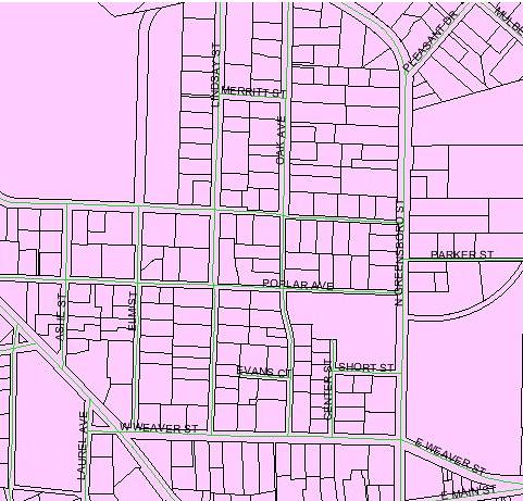
Here in southern Orange County, there is also vestigial evidence of former Native American settlement. Old Field Creek, which flows northeast out of Chapel Hill into New Hope Creek was almost certainly the site of some sort of Native settlement. The term ‘old field’ in old North Carolina land records refers to lands that were developed agriculturally by Native Americans – land that had been cleared before the arrival of Europeans – literally old fields – ancient fields. Further to the west of here, the Haw Old Fields had belonged to the Sissipehaw or Saxapahaw people into the 1720’s, when a major smallpox epidemic ravaged the Native Americans of the North Carolina Piedmont.
 |
| The Saxapahaw Old Fields |
That great North Carolina explorer and chronicler John Lawson wrote of his journey through this vicinity in his book A New Voyage to Carolina. In traveling through the area in 1701, Lawson remarked: “Here is plenty of good Timber, and especially, of a Scaly-bark'd Oak; And as there is Stone enough in both Rivers, and the Land is extraordinary Rich, no Man that will be content within the Bounds of Reason, can have any grounds to dislike it.” Lawson does not much discuss the Native people in this area, but he does refer to the Hawfields in saying: “The Savages do, indeed, still possess the Flower of Carolina, the English enjoying only the Fag-end of that fine Country.”
Though Lawson gives few details in this part of his book, he does say that the Native Americans were living there, and in the same breath he hopes for colonization: “It is call'd Hau-River, from the Sissipahau Indians, who dwell upon this Stream, which is one of the main Branches of Cape-Fair, there being rich Land enough to contain some Thousands of Families; for which Reason, I hope, in a short time, it will be planted.”
It is clear that from earliest times the Europeans admired the area that is now Orange County. Lawson related in 1701: “The Virginia-Men asking our Opinion of the Country we were then in, we told them, it was a very pleasant one. They were all of the same Opinion, and affirm'd, That they had never seen 20 Miles of such extraordinary rich Land, lying all together, like that betwixt Hau-River and the Achonechy Town.”
European settlers kept essentially no records of the Native Americans they encountered upon arriving in Orange County and so it is unclear how many Native Americans there were at the time of European settlement. But it is clear that there were at least some Native people still here at that time.
Even as late as 1770, the former Native American presence in our county was still palpable, as John F. D. Smyth related in A Tour of the United States of America Containing an Account of the Present Situation of that Country: “I have reason to believe, that some of the Haw fields have been cleared of woods by the Indians, in ages past, who were undoubtedly settled here; many insignia, and vestiges of the remains of their towns, still remaining.”
How the West Was Lost
Unlike some parts of the United States, there was never any treaty or agreement signed between the Europeans and either the Saxapahaw or the Eno people. Instead of relying on the terms of some sort of dubious treaty, the Europeans pointed to a still shakier source of land title authority.
In 1585, Sir Richard Grenville, the head of Sir Walter Raleigh’s first colonization party sailed to the Outer Banks. Grenville and his men then explored along the outer banks encountering various Native settlements including the village of Aquascogoc. The Englishmen accused the Algoquin natives of stealing one of their cups and in retaliation sacked their village and burned their chief at the stake. With this moral foundation, Grenville laid claim to ‘Virginia’ on behalf of Queen Elizabeth. As conceived at that time, Virginia included the entire east coast, from the Spanish colonies in Florida north to the French settlements in Quebec. Of course, the resulting Roanoke Island Colony soon became the Lost Colony. Still, the Crown maintained that Grenville’s 1585 ceremonial declaration entitled the English to most of North America.
Queen Elizabeth did little with the area that became North Carolina after the disappearance of the Roanoke Island Colony. In the early 1600’s, English colonization shifted to Jamestown, VA and Plymouth, MA. Charles I attempted to restart colonization in North Carolina in 1629, but he was executed by Oliver Cromwell in 1630. After the restoration of the monarchy in 1660, Charles II rewarded his allies with huge and valuable real estate grants. Through several twists and turns of fate and history, one man wound up with a deed to the northernmost sixty miles of North Carolina – literally a swath of North Carolina extending due west from the Outer Banks, bounded on the north by what is now the Virginia State line and extending south to what is now the southern boundary of Chatham and Randolph Counties, NC. That man happened to be the grandson of Sir Richard Grenville: John Carteret, Earl Granville.
The Origins of Land Title in Orange County
Earl Granville’s deed included all of what is now Orange County. And from 1744 until his death in 1763, Earl Granville issued deeds to the European settlers who came and staked claims on the land that had once been the land of the Eno and Saxapahaw. These deeds from Granville comprised a major portion of modern Orange County. Probably somewhere around half of Orange County’s current land area traces its title history back to one or another of Granville’s grants, including most of Chapel Hill, Carrboro, and Hillsborough as well as many other areas of the county.
After Granville’s death, his estate was embroiled in a grand legal battle in the English courts in London and the estate was not settled until well after the American Revolution. During the 15 years between Granville’s death and the Revolution, much of the rest of Orange County was occupied by European immigrants. But these relative newcomers were unable to obtain title to the lands that they were occupying because of the on-going legal battle over Earl Granville’s estate. This problem (which existed affected many counties) was at the top of the non-military agenda of the newly impaneled legislature of North Carolina. The issue was such a priority that despite the then on-going Revolutionary War, the General Assembly passed legislation making it clear that the lands in North Carolina formerly belonging to Earl Granville (as well as the King) were forfeited to the new State of North Carolina.
So it was that in 1778, the legislature created the North Carolina State Land Grant system. Virtually all of the remaining land in Orange County that had not already been granted by Granville was soon granted to the settlers who were then on the land. Thus, the other half of Orange County’s land area traces its title history back to one or another of these State Land Grants.
So, regardless of whether a particular piece of land in Orange County was originally granted by Earl Granville or by the State of North Carolina, the ultimate source of its legal authority is founded on a brief ceremony conducted by Sir Richard Grenville 200 miles east of here, 426 years ago, immediately following the sacking of Aquascogoc.
Justice Too Long Delayed?
My point in recounting this long tale of woe is this: Across America there were many different methods used to cheat, steal and defraud the Native Americans out of their land, but in the area that is now Orange County, the land was simply occupied by the Europeans under the pretense that Grenville’s 1585 claim staked on the Outer Banks wound up vesting valid title in the hands of Earl Granville and later the State of North Carolina. No person of conscience could seriously believe that this was a just or even legally valid result.
Many people would probably argue that we cannot be held responsible for the wrongdoing of our forbearers and others would argue that whatever injustices happened in the past, the victims of those wrongs have been dead for centuries. But it seems to me that all of us who own real estate in Orange County benefit to this very day from unjust acts carried out centuries ago – not in some abstract or theoretical way, but in a way that history still demonstrates. And though the victims of those injustices have indeed been dead for centuries, their descendants are still among us here today.
http://www.obsn.org/show/page/the-voice-of-the-occaneechi-nation
In fact, not only are their descendants among us, living along the border of Alamance and Orange County, but they are organized and working on economic development through heritage tourism. I believe that in the past they have sought help from both the Orange and Alamance Boards of County Commissioners.
So, my question is this: While we will never be able to lift the moral and ethical cloud that hangs over the actions of our predecessors, could there ever be a way to lift the legal and moral cloud that hangs over all modern land titles in Orange County? What if, as a County, we were to explore a partnership with the Occaneechi Band to promote heritage tourism and economic development through their proposed park/museum, and as a part of such a partnership the Occaneechi Band might agree to what would essentially be a quitclaim deed to the entirety of Orange County?
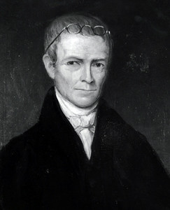
How the West Was Lost
Unlike some parts of the United States, there was never any treaty or agreement signed between the Europeans and either the Saxapahaw or the Eno people. Instead of relying on the terms of some sort of dubious treaty, the Europeans pointed to a still shakier source of land title authority.
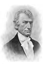
 |
| Sir Richard Grenville |
In 1585, Sir Richard Grenville, the head of Sir Walter Raleigh’s first colonization party sailed to the Outer Banks. Grenville and his men then explored along the outer banks encountering various Native settlements including the village of Aquascogoc. The Englishmen accused the Algoquin natives of stealing one of their cups and in retaliation sacked their village and burned their chief at the stake. With this moral foundation, Grenville laid claim to ‘Virginia’ on behalf of Queen Elizabeth. As conceived at that time, Virginia included the entire east coast, from the Spanish colonies in Florida north to the French settlements in Quebec. Of course, the resulting Roanoke Island Colony soon became the Lost Colony. Still, the Crown maintained that Grenville’s 1585 ceremonial declaration entitled the English to most of North America.
Queen Elizabeth did little with the area that became North Carolina after the disappearance of the Roanoke Island Colony. In the early 1600’s, English colonization shifted to Jamestown, VA and Plymouth, MA. Charles I attempted to restart colonization in North Carolina in 1629, but he was executed by Oliver Cromwell in 1630. After the restoration of the monarchy in 1660, Charles II rewarded his allies with huge and valuable real estate grants. Through several twists and turns of fate and history, one man wound up with a deed to the northernmost sixty miles of North Carolina – literally a swath of North Carolina extending due west from the Outer Banks, bounded on the north by what is now the Virginia State line and extending south to what is now the southern boundary of Chatham and Randolph Counties, NC. That man happened to be the grandson of Sir Richard Grenville: John Carteret, Earl Granville.
The Origins of Land Title in Orange County
Earl Granville’s deed included all of what is now Orange County. And from 1744 until his death in 1763, Earl Granville issued deeds to the European settlers who came and staked claims on the land that had once been the land of the Eno and Saxapahaw. These deeds from Granville comprised a major portion of modern Orange County. Probably somewhere around half of Orange County’s current land area traces its title history back to one or another of Granville’s grants, including most of Chapel Hill, Carrboro, and Hillsborough as well as many other areas of the county.
 |
| John Carteret, Earl Granville |
After Granville’s death, his estate was embroiled in a grand legal battle in the English courts in London and the estate was not settled until well after the American Revolution. During the 15 years between Granville’s death and the Revolution, much of the rest of Orange County was occupied by European immigrants. But these relative newcomers were unable to obtain title to the lands that they were occupying because of the on-going legal battle over Earl Granville’s estate. This problem (which existed affected many counties) was at the top of the non-military agenda of the newly impaneled legislature of North Carolina. The issue was such a priority that despite the then on-going Revolutionary War, the General Assembly passed legislation making it clear that the lands in North Carolina formerly belonging to Earl Granville (as well as the King) were forfeited to the new State of North Carolina.
So it was that in 1778, the legislature created the North Carolina State Land Grant system. Virtually all of the remaining land in Orange County that had not already been granted by Granville was soon granted to the settlers who were then on the land. Thus, the other half of Orange County’s land area traces its title history back to one or another of these State Land Grants.
So, regardless of whether a particular piece of land in Orange County was originally granted by Earl Granville or by the State of North Carolina, the ultimate source of its legal authority is founded on a brief ceremony conducted by Sir Richard Grenville 200 miles east of here, 426 years ago, immediately following the sacking of Aquascogoc.
Justice Too Long Delayed?
My point in recounting this long tale of woe is this: Across America there were many different methods used to cheat, steal and defraud the Native Americans out of their land, but in the area that is now Orange County, the land was simply occupied by the Europeans under the pretense that Grenville’s 1585 claim staked on the Outer Banks wound up vesting valid title in the hands of Earl Granville and later the State of North Carolina. No person of conscience could seriously believe that this was a just or even legally valid result.
Many people would probably argue that we cannot be held responsible for the wrongdoing of our forbearers and others would argue that whatever injustices happened in the past, the victims of those wrongs have been dead for centuries. But it seems to me that all of us who own real estate in Orange County benefit to this very day from unjust acts carried out centuries ago – not in some abstract or theoretical way, but in a way that history still demonstrates. And though the victims of those injustices have indeed been dead for centuries, their descendants are still among us here today.
http://www.obsn.org/show/page/the-voice-of-the-occaneechi-nation
In fact, not only are their descendants among us, living along the border of Alamance and Orange County, but they are organized and working on economic development through heritage tourism. I believe that in the past they have sought help from both the Orange and Alamance Boards of County Commissioners.
So, my question is this: While we will never be able to lift the moral and ethical cloud that hangs over the actions of our predecessors, could there ever be a way to lift the legal and moral cloud that hangs over all modern land titles in Orange County? What if, as a County, we were to explore a partnership with the Occaneechi Band to promote heritage tourism and economic development through their proposed park/museum, and as a part of such a partnership the Occaneechi Band might agree to what would essentially be a quitclaim deed to the entirety of Orange County?
![6 Piper_Donation[1]](http://farm3.static.flickr.com/2689/4297026797_9c832c9ea1.jpg)