Thursday, December 23, 2010

The Hermitage

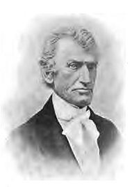
The two of Alamance County's most prominent historical figures lived just opposite Swepsonville near the confluence of Big Alamance Creek and the Haw River. Archibald D. Murphey was the founder of lower public education, a great proponent of internal improvements (canals, plank roads etc.), a lawyer, a judge and a state senator.

115-b-MurpheyArchibald_FP02-M978-A673d_web
Judge and Sen. Archibald Debow Murphey

Murphey nearly went bankrupt in the banking crisis of 1819 and was forced to surrender his extensive real estate holdings to his friend and creditor Thomas Ruffin. Ruffin became an even more eminent (and later infamous) figure serving on the NC Supreme Court and authoring the Court's opinion in State vs. Mann.
200px-Thomas_Ruffin
NC Chief Justice Thomas Ruffin

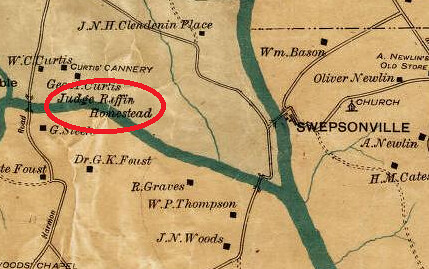
The homeplace of Murphey and later Ruffin was called the Hermitage. According to the Papers of Archibald Debow Murphey (pp334-335), the Hermitage stood "three miles south of the site of Graham and about half a mile from the stage road leading from Hillsboro via the Hawfields to Salisbury." Murphey (and later Ruffin owned) the waterpower site which later became Virginia Mills in Swepsonville. "The mills were about two miles to the east [of the Hermitage], at the confluence of Haw River and Great Alamance."

The site of the Hermitage is shown on W L Spoon's 1893 Map of Alamance County:

The Hermitage

The Papers of A D Murpehy described the site: "A lane ran southward from the public road to the front gate, where it turned to the right and ran along the northern border of the yard and into an enclosure containing the kitchen, servants' quarters stables, and other outbuildings. On the eastern side of the dwelling-house, about thirty feet from it, stood Murphey's law office, and under the office was a wine cellar. Further east was an orchard. In the rear of the house was a garden, which adjoined a lot lying on Great Alamance Creek."

"The house was a plain, substantial wooden building having two stories in the central portion and one and a half in the winds on the eastern and western sides. At the right end of a large hall as one entered was a room called Judge Ruffin's room after he took up his abode there, and at the left a library and parlor. These rooms formed the first stories of the wings. At the back of the hall were the dining-room and a guest chamber, and behind these a narrow hall, with a pantry and storeroom at its ends, and a piazza overlooking the garden and creek. Upstairs, in the central portion of the house was another large hall, and in the rear two bedrooms, a storeroom, and a back hall. Two spacious guest chamber, with four dormer windows in each, formed the second floors of the wings."

As authority for such a detailed description of the house, the editor of Murphey's papers tells us: "For this description I am indebted to Col Bennehan Cameron, of Stagville, who often visited the Hermitage during his boyhood."

Friday, December 10, 2010

A Tolerable Bateau Navigation

Here's an excerpt from my next forthcoming book A Tolerable Bateau Navigation: The Story of the Deep and Haw River Navigation Company, 1796-1881. You can order the book via email: Mark_Chilton@hotmail.com


Round IV on the Upper Cape Fear: A Bateau Navigation 1828-1832


By the fall of 1828, the Fayetteville Observer was already complaining again about the Cape Fear Navigation Company’s emphasis on the Upper Cape Fear: “We understand that the hands employed upon our River are at work 20 or 30 miles above this town; to which no one could have a reasonable objection, if the Navigation Company had really removed the obstructions between this place and Wilmington, and had the funds left to prosecute the works above . . . The Navigation Company may possibly be promoting their own interests by their operations; but the merchants and boat owners here complain, and apparently with reason, that they pay heavy tolls, for no good that they can see except to furnish money to prosecute a visionary scheme of opening a navigation to Haywood, or Murphey’s Mills [Swepsonville]. Is there no remedy?” In response, the Board of Internal Improvements’ engineer Alanson Nash supervised the removal of snags below Fayetteville and the construction of an additional wing dam at Spring Hill Shoal (Observer 10/30/1828). Nash also reported that more such improvements were needed at the ferry at Elizabethtown and at the old ferry site a few miles below (1828 Report).


The summer of 1829 was a time of great optimism for the Cape Fear Navigation Co. The renewed investment from the State of North Carolina was making it possible to make major progress on improving the river above Fayetteville and the passable condition of the lower Cape Fear was allowing the Company to collect significant tolls. As the Recorder reported (6/10/1829) the CFN Company’s Directors at their annual meeting found “the affairs of the Company in a much more prosperous situation than at any other meeting during the time they have had the honor to direct its concerns.”


In fact, the papers were full of promising reports about navigation of the upper Cape Fear in the summer and fall of 1829. By July, the Recorder said that work on the Buckhorn locks was complete and that hands had been moved down to Smiley’s Falls (7/20/1829), allowing Haywood businessman Jonathan Haralson to send his boat the Clara Fisher to Fayetteville with 27 bales of cotton using hired boat hands (see also Observer 5/28/1829). Work was still progressing at Smiley’s Falls in September, but Archibald D. Murphey was able to send his boat from Haywood to Fayetteville (Recorder 9/23/1829). And still another trip through Smiley’s Falls reportedly at low water and at night was approvingly noted in October that year (Observer 10/22/1829).


The newspaper accounts certainly make it appear that the navigation of the Upper Cape Fear was complete by the end of 1829. As the Recorder (9/23/1829) put it: “The river, for the first time this season, is in good working order and nothing is wanting but hands for which liberal wages are offered.” But high-water in the winter of 1829-30 must have been hard on the works put in place in 1828 and 1829, as the summer of 1830 saw a furious new round of improvements under way above Fayetteville.


In 1830, the BII’s superintendent on the river, Abraham G. Keen built a breakwater dam at Haralson's landing, blasted ledges and built wing dams at Upper Little river falls, built more wing dams at Williams' Falls, and removed fish traps at Borough Shoals. They did more blasting and built more wing dams at Stewart's Creek ledge, at Shaw's Upper Falls and Wirt's Fish Stand Falls, at Thorington Creek Shoals , and at Jones Falls and Massie's Fish Stand Falls - to say nothing of wing dams built at M'Craney's Fish Stand Falls, Dry Creek Shoals, Norrington's Falls, Ford Shoals, Mrs. Atkins Ferry Shoal, John Atkin's Fish Trap Shoals, M'Neal Shoals, Guess Ford Shoals, James Battle's Falls, Blalock's Falls, and Brazier Falls. And they also built "several other dams." To his credit, Mr. Keen complained only that "[o]wing to the extreme low water this summer, I had a great deal of unnecessary work to do to enable us to get up the river with our loaded boats." (1830 Report)


The sweaty and noisy summer of 1830 must have resulted in a notable level of success. The BII met in June of 1830 at Haywood (Observer 6/10/1830) and “proceeded down the River in one of the Company’s boats, accompanied by several of the neighboring planters, and there being no obstruction in the River for ten miles, they had a pleasant passage to the dam across it near the Buckhorn Falls . . . The Boat then entered an outlet from the river which leads to the Buckhorn Canal. The river being low, Mr. Keene had some fears that it would not be found sufficient to carry the boat through the Locks; but the event found his fears groundless . . . and when [the boat] again entered the river, it met with but few obstructions. It had indeed to pass a number of inconsiderable falls, and some very shoal places; but from the sluices cut through the former, and the activity of the hands in managing over the latter, but little inconvenience was sustained from either.” The report allowed that the passage through Smiley’s Falls was rapid, but successful owing to wing dams, sluices and blasting that had been going on. Along the side of these long Sluices are erected substantial Stone Walls, which serve for towing paths for ascending boats.” (See also Observer 7/15/1830)


In fact, the level of optimism about the improvements to the upper Cape Fear was so high that some quarters seemed to think that boats, rather than wing dams were the missing ingredient. “As soon as it shall be generally known that there is a good navigation opened between Haywood and Fayetteville,” the Observer opined, “there is no doubt that the planters within a reasonable distance from the River, will avail themselves of this easy mode of sending their crops to market.” (Observer 6/10/1830) Even George M'Neill, no admirer of the Board of Internal Improvements, grudgingly admitted: "[T]he River was sluiced through Smiley's falls, and other falls between Fayetteville and Averasborough, which afforded a tolerable navigation for such bateaus as could pass the Canal and Locks at Buckhorn falls." (1838 Report)


The Backlash


In late 1830 increasing frustration with the Navigation Company led to sharp criticism in the newspapers. An anonymous letter to the editor of the Observer of 11/25/1830 bemoaned the navigation problems below Fayetteville and asked: “Why have not the stockholders for the last 3 years foreseen these fatal consequences at their general meetings? The only answer that can be given to that question is that the well known zeal manifested by Mr. [CFN Co. President James] Mebane in promoting operations above Fayetteville, and his representation of the 650 shares of stock owned by the State (and which generally constitutes a majority of stock represented at those meetings) precludes the possibility of any successful argument in favor of the true interests of the Company.” Still more criticism was published 12/2/1830 and on 12/23/1830. The Observer reported that a group of Wilmington residents had organized a petition to the legislature to revoke the CFN’s power to charge tolls on the river because of the shortcomings of the Company’s efforts between Fayetteville and Wilmington.

This critical sentiment was also reflected in the CFN Company’s annual report to the BII in 1830. "When the work now in progress, under the direction of your Board, between Fayetteville and Haywood is completed, it is hoped that the large sum expended at and about Buckhorn Falls will not be entirely unproductive. The Canal at and near Fayetteville is not likely to yield the company any income; but, on the contrary, it is a continual expense." (emphasis in original).


In 1831, there was evidently renewed unhappiness with the company in the legislature, as the Board of Internal Improvements was directed to assess the question of what had been accomplished by the Company . . .


For the rest of the story, please order a copy of the book via email: Mark_Chilton@hotmail.com
Sunday, December 5, 2010

McCulloh's Petition to the King

I transcripted this from a hand written collection of Henry McCulloh's writings contained in the Manuscripts collection of Duke University:

General Observations in Relation to the Steps which were taken previous to the Earl of Granville’s division of the Two Carolina’s with the Crown

Lord Granville by His Petitions to His Majeesty humbly Prayed His Majesty that his one eighth part of the Soail of the Two Carolina’s might be set out and alotted to him in such part of the said Provinces asshould be Agreed on between such Persons a His Majesty should be pleased to appoint and such Persons as the said Lord Granville should name on his part.

His Majesty was pleased to referr the said Petition to the Right Homble the Lords of the Committee of Council and their Lordships referred the same to the Right Honble the Commissioners of Trade and Plantation for them to Consider thereof and Report their Opinion thereupon.

And in pursuance thereof their Lordships did Report That they conceived the method proposed by the said Lord Granville would be the most Effectual.

Which said Report the Lords off the Committee of His Majesies most Honble Privy Council did agree to and on the Twenty Fourth of August 1742 made their Report thereupn to His Majexty and gave it as their Opinion that the said Lord Granville’s Property should be Separated from that of His Majesty, and humbly proposed that proper Persons should be appointed as Commissioners on His Majesties behalf not exceeding Five who in Conjunction with the like Number of Persons to be appointed by the said Lord Granville, should be Impowered to Sett out and Alott to the said Lord Granville One full Eighth part of the said Provinces of Carolina in such part of parts of the siad Provinces as should be Agreed upon by the said Commissioners. And that they should be required to make a Return of their Proceedings to His Majexty in council within Eighteen Months from the dates of His Majesties Order. And alsoto lay before His Majesty A Plan containing a full and exact Description of the said Land together with the respective Boundaries thereof.

And for the better Guidance of the said Commissioners that it might be Advisable for His Majexty to require the said Commissioners to follow and Observe such Direstions and Instructions as might be given from time to time either by His Majesty or by those who act under His Majesties Royal Authority.

Which Report His Majesty was pleased to Approve of as may more fully and at large Appear by His Majesties Order of Council dated Fifteenth day of September 1742.
And in pursuance thereof His Majesty by His Royal Instructions thereupon given the Tenty fifith day of April 1743. Required and Commanded the Commissioners to make a Return of the whole of their Proceedings within Eighteen Months from the date of the said Order, and also required them to transmit a full and Exact description of the Lands so to be set out and Alotted to the said Lord Granville with the respective Boundaries thereof. And that the said Commissioners should follow such Instructions as might be found necessary to be given to them either by His Majesty or by those who act under His Majexties Royal Authority.

His Grace the Duke of Newcastle (as Conceived at Mr Belaquier’s Request) wrote a Letter to the Governor of North Carolina dated the Ninth of June 1743, including a Plan drawn in London of such part of North Carolina as was deemed to be an Eighth part of the whole of the said Province but His Grace did not direct that the Commissioners should follow the said plan and only sent it as what might be of Service to His Majesty’s Commissioners in making the said Division.
Mr. Belaquie by his Letter dated eleventh June 1743 to Col. Edward Moseley who was Lord Granville’s Agent inclosed to him a Map or Plan of said tract drawn by Mr. Warner in London with directions hiw to proceed in that matter for Ld. Granville’s Service.

And Mr. Belaquier in his Letter to me dated Eleventh June 1743 wished that his Lordship had Signed a Commission at Hanover Appointing Commissioner sin his behald, and had given the necessary Instructions to Mr. Moseley which were to be Communicated to me. That he had Transmitted to mr Moseley a Copy of the Duke of Newcastles’s Letter to the Governour dated the Ninth of June 1743 Including a Map or Draught of such a Tract of North Carolina adjoining to Virginia as is deemed to be an Eighth part of the whole, together with some ____ amd directions upon the same as what may possibly be of use to His Majesties Commissioners. And Mr. Balaquier further said that he had in Command from his Lordship to Assure Mr. McCulloh that His Lordship would be Obliged to him for his Complyance with the several Matters above mentioned.

I pray leave to Observe that as Lord Granville was then Secretary of State and that His Majexty had Commanded the Commissioners to Observe such Instructions as were given to them by those who Acted under His Majesties Royal Authority I did not Conceive myself to be at Liberty to Oppose Mr. Moseleye in any Matter which related to His Lordship.

The Commissioners in behalf of the Crown and those Appointed by Lord Granville met together in October 1743. And on looking into His Majesties Orders of Council and the other Letters and Papers transmitted to them Did not Apprehend themselves to be at Liberty to do any thing further than to lay out the Latitude, and then to run a West Line, and accordingly went upon that Duty without taking the Oaths usually required in such cases to do Justice to each of the Parties.

The Season of the Year being then far Advanced and the Commiss.ers being required to make a return within Eighteen Months from the date of His Majesties Order in Council, they did not run the West Line further than to a place called Pamticoe River.

The Return made to His Majesty by the Commissioners is dated the Sixth of December 1743 Setting forth that in pursuance of His Majesties Royal Order in Council dated Fifteenth September 1742 and Instructions dated 25th April 1743 they did set out and Alott to Lord Granville One full Eighth part of the Provinces of North Carolina next Adjoining to Virginia on the East by the great Western Ocean. And as for southwardly as a Cedar Stake set on the Sea side in the Latitude Twenty five Degrees and Thirty four Minutes North Latitude being Six Miles and an half to the southward of Chickinacomack Inlet from that Stake by a West Line which passed Tenty five Foot to the Southward of the House where Thomas Willis lived to the West as far as the Bounds limited by the Charter granted to the Late Lords Proprietors. Which West Line was run One Thousand Six hundred and sixty Poles to the North of the South end of Bath Town.

All which was most humbly Submitted &c &c &c.

At the time of making that Return a Plan was also Transmitted which had been Separated and set out for Lord Granville with a Scale of Miles Annexed thereto.

It is proper to Observe here that the Commissioners did not say that the Plan so Transmitted was a full and Exact description of the Return made by them nor in Truth was it, there being a Supposed Line given in the following words which were not contained in the Plan, namely So West as far as the bounds of the Charter granted to the late Lords Proprietors.

The Return was drawn up by Lord Granville’s own Agent, and so gave roo for the deception whicafterwards Appeared in the Prosecution of the said Affair.

By His Majesties Orders the Plan and Return were to Agree, as by the Plan would Apear what Extent of Country was Alotted to His Lordship. But the Commissioners having acted only by a Suppsed Plan sent to them they had not time to run the Boundary Line, not to perfect their Plan and Consequently sent in Open.

However this being about the time when Lord Granville resigned his Commission as Secretary of State, he was willing to have the matter determined. And the Affair was Represented to the Lords of the Committee of Council as to Cause in them an Opinion that the Return and Plan were one and the same as will more fully appear by the following Report.

The Right Honourable the Lords of the Committee of Council on taking the said Returna nd Plan into Consideration the Nonth day of May 1744 were pleased to Report to His Majesty that the Commissioners having transmitted to His Majesty a Plan containing a full and Exact description of the said One Eighth part of the said Provinces or Territories so set out and alotted to the said Lord Granville Their Lordships were humbly of Opinion that His Majexty might be pleased to Approve of the said Return and Plan and the Alottment thereby made to the said Lord Granville. And that thererupon it might be advisable for His Majesty to Order his Attorney and Solicitor General to prepare the necessary Instruments or Deeds Conformable to what was ---- Contained in the aforesaid Reports.

It is to be Remarked that when the Return and the Plan were copied out in Order to be laid before His Majesties Attorney General, the following words were added to the Copy of the Return, Viz: “And the said Commissioners did pursuant to His Majesties Order in Council Transmit to His Majesty a Plan containing a Full and Exact Description of the said One Eighth part of the said Provinces or Territories so set out and Alotted to the said Lord Granville.”
It is very probable that if the above words had not been so added to or inserted in the Copy of the Return made by the Commissioners that His Majesties Attorney General would have perceived the great difference which really was between the Return and the Plan, so that the necessary Instruments and Deeds could not have been made out agreeable to what is contained in the aforementioned Reports.

The deeds as drawn by the Attorney General are worded with Extreme Caution and Convey to Lord Granville only such Eighth part of the said Provinces or Territories as are Separated set out and Alotted to Lord Granville.

Which words (as concieved) are really Conjunctive and so Lord Granville Cannot avail himself of any more Lands under the said Grant than what are Comprized within the Plan returned by the Commissioners Especially for that the said Plan and Report Annexed thereto as laid before the Attorney General are said to Conaitna a full and Exact description of the said One fulll Eighth part of the said Provinces or Territories so set out and Alotted to the said Lord Granville.
But Lord Granville being of Opinion that the supposed Line above mentioned might still be Carried into Execution and a New Line run out.

Mr. Moseley his Lordships Agent prevailed on the Governour to Appoint the same Commissioners who were formerly authorized by His Majesty (although their Commission was then Expired near Two Years) to meet such Commissioners as Lord Granville then Appointed. And they accordingly met the latter End of March 1746 and run a further Line for Lord Granville from Pamticoe River to the Westward of Nues River. And they having met again in September 1746 run a further Line from Nues River to the Westward of Peedee River including the whole of the said ___ survey about One hundred and forty Miles in length, and if the supposed Line should ___ be carried on, it will Extend at least Two hundred and fifty Miles further.
In running the said Lines the Commissioners did not make any Allowance for the difference which induced me at my own Expence to Employ one of His Majesties Deputy Surveyors to Measure the Distance between Lord Granville’s Line on Pedee River to the Virginia Line, and on Surveying of the same it was found that Lord Granville had Thirteen Miles and hald in Breadth more than he was Intitled to, even Admitting that the Commissioners had a Power to proceed further on the said supposed Line.

If Lord Granville should be Allowed to keep possession of all he Claims under the Supposed Line, One Fifth part and more of the Provinces of South and Norht Carolina will come within His Lordship’s Division, Whereby One Fourth part and more of the White Inhabitants of the said Colonies will be Included therein.

But if Lord Granville should be restrained or Limitted to what is Comprized in the first Survey and Plan returned thereon His Lordship will not possess above one Twelfth part of the Lands, Althoguh in Value and point of Settlement it is more than equal to an Eighth part of the whole Provinces.

My Motive in troubling your Royal Highness with the above Representation is to Evince the Truth of my former Remarks and shew that when the Rules of Office are dispensed with, not only the Crown but the Lords of the Privy Council are Subject to Surprize.