I got to wondering just where the Piper Donation was. I made a bit of a mash up of the 1817 Plan of Chapel Hill, the 1792 Daniel Map of UNC, and the 2009 Orange County GIS tax maps, tying together the dog leg western boundary of the campus, the lots at the corner of Franklin and Columbia Street and the position of the Patterson Donation shown on the Daniel map. The result is very interesting.
The Piper Donation was what would later become Downtown Carrboro:
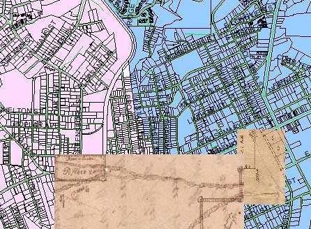
The tract appears to have run from the rail line on the east to Oak Avenue on the west and from Weaver Street south to the south edge of the lots along Main Street. In other words, some pretty nice real estate by modern standards.
Of course, back in 1792, there was not that much there in terms of development. Two roads ran through the property. The north fork was essentially what is now Weaver Street, turning northward and following Main Street, and then Hillsborough Road to Hillsborough. The south fork led to McCauley's Mill, a grist mill that stood about where University Lake dam is now; no modern road really tracks this course.
You will commonly hear it said that Carrboro grew up where it did because that is where the railhead was - that is, the rail lines didn't used to continue south of Main Street. So a railroad station was built and a grist mill and other industries grew up around the railhead. That area came to be called West End (of Chapel Hill) and was eventually incorporated into the Town of Venable, soon renamed Carrboro after the owner of the big hosiery mill.
But it appears that the railhead was probably located in that spot because it was the edge of the Piper Donation. UNC owned the land, and they must have agreed to have the rail line come to that point. Or so it appears.


Battle mentions a few other things about the area that would one day become Carrboro: "Another trouble the Faculty had was in regard to horse-racing. There was a track near the Hill, a few hundred yards west of the railroad station. The races were inaugurated largely by liquor sellers and gamblers, and were frequented by many drunken and disorderly persons. The students were forbidden to attend, but some went disguised and undetected. Those caught were suspended from the institution."
ReplyDeleteBattle tells us: "Alexander Piper was a plain farmer who removed to Fayette County, Tennessee, many years ago."
ReplyDeleteApparently this is the same person:
ReplyDeleteAlexander Piper born 1762 in Orange County, North Carolina; died Bef. May 15, 1817 in
Smith County, Tennessee; abt. 1800 married Patsey Gregory, born Bet. 1780 - 1790 in North Carolina; died 1840's in Smith County, TN.
Here is the abstract of the deed from Alexander Piper to UNC: 20 acres, begin at a post oak James Craig's corner, West 80 poles to a black jack oak, South 40 poles to a black jack oak, East 80 poles toa black jack oak, North 40 poles to the beginning. Deed date 18 Oct. 1796, although the pledge of this land was made in 1792.
ReplyDeleteNotice that this description matches the map very nicely - the parcel is twice as long east-west as it is north-south - both on the map and per the deed (80x40). The map appears to say 20 acres, which is also the size the deed lists. And the scale of the map supports the conclusion that the Piper Donation shown on ths map is 40 poles by 80 poles (ie 600 feet x 1000 feet).
Correction: 500 feet x 1,000 feet.
ReplyDeleteThis same property was resold by UNC in 1837 to John M Craig for $40 (Orange DB 28, pg 272). Craig's estate sold a larger parcel (presumably including the Piper Donation) for $115 in 1867:
ReplyDelete"lying on the western outskirts of Chapel Hill upon both sides of the road leading from Chapel Hill to Greensboro adjoining the lands of John Weaver, Thomas Weaver, and others and bounded as follows: Beginning at the mud hole in Craigs Lane upon said Road running thence N6W 50.25 chains to a cedar thence West 1.88 chains to pointers thence S47.5W 15.5 chains to a gum thence S37.25W 9.90 chains to a locust on the road leading to Greensboro then S45E to a rock 5.1 chains thence S 19.6 chains to a post oak stump thence W 15 chains to a post oak William Weaver's corner thence S 10 chains to pointers thence 15 chains to a rock in the road from Chapel Hill to Jones Ford on Haw River thence E with the said Road 21.25 chains to the beginning containting 101 1/2 cares more or less."
The deed from John M Craig estate was to William L Saunders (ODB 39, pg 312). Saunders sold the same property to Hanry H Patterson and Fendal S Hogan in 1879 (ODB 46, pg 257):
ReplyDelete"near the western limits of the town of Chapel Hill and Ajoining the lands of James F Craig on the east, John H Weaver on the north and William Weaver on the west and lying along the Burnt Shop or old Hillsboro road being the same tract of land bought by said William L Sanders from . . . James M Craig and containing 101.5 acres."
I believe that Burnt Shop is an early name for the Melville community in Alamance County, essentially just north of Swepsonville.
ReplyDeleteDave Otto recently wrote: "You touched on a lot of people and events that I was not familiar with--e.g., Alexander Piper's 20 acre donation to UNC and its later sale to Craig and Patterson. Was it then sold to Thos. Lloyd?"
ReplyDeleteWell, all I can say is apparently so. I have not been able to find a deed to Thomas F. Lloyd for any of his various holdings in downtown Carrboro, however I did take a photo of a rather illegible plat at the register of deeds office which shows the triangular block where the century center now stands.
The plat shows a subdivision of that block and at the bottom in nearly insrutable handwriting it says that the land was sold by Henry Patterson to Thomas Lloyd, but no deed book is cited to support that.
I will try to post a picture of that plat shortly. I unfortunately failed to write down the plat reference when I took the picture, but it was definitely from Plat Book 1.